
Category: Countries
-

god given 904 of The Vyrkans Root Cracker
From: Archaicism The Faith of Vyrkan Lore The god given 904 of The Vyrkan’s Root-Cracker is not a manufactured item but a grown blessing. According to Archaic legend, these tools appeared after the Wiltfall as a gift from Vyrkan to ensure no city would ever over-harvest the ley lines again. Each cracker is a single…
-
god given 814 of The Stonegrowers Steady Hand
From: Andeanism The Faith of Intayra Lore: The god given 814 of The Stonegrower’s Steady Hand is a physical manifestation of Intayra’s Prosperous trait. Legends say these tools were first “harvested” from the mountain itself after the Peak Ascension, when Intayra’s steam-wreathed figure cooled into the first andean cities. Each tool is considered a “living…
-

god given 412 of The Sifting Stillness
From: Amratianism The Faith of Zephara Lore The god given 412 of The Sifting Stillness is whispered to be a miracle born from the first breath Zephara gave to the desert. Legend says that during the Sand Awakening, a wanderer lost in a recursive sandstorm sat in perfect silence, accepting their end. In that moment…
-

god given 842 of the Abyssal Drift
From: Aegeanism The Faith of Thalindra Lore The god given 842 of the Abyssal Drift is whispered to be a divine blessing from Thalindra herself. Legend tells of a lost navigator who, in a moment of absolute stillness amidst a great storm, found this silver compass pendant resting in the palm of their hand. The…
-

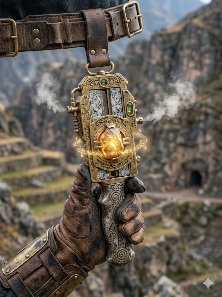
god given 429 of The Ember Scribes Calking
From: Acheuleanism The Faith of Korrath Lore In the industrial heart of Acheulean, the Ember-Scribe’s Calking is whispered to be a “miracle” for the unrefined Isekai soul. According to the Firetenders of Korrath, these specialized Steampunk Leather Gauntlets were first manifested when a nameless traveler from a world of logic tried to grasp a molten…
-

god given 822 of The Rippling monocle
From: Aboriginalism The Faith of Yirra Lore In the floating metropolis of Dreamtide, the first lesson a young Waterdreamer learns is that the world is never quite what it seems. The Rippling Monocle is a “god-given” gift often found resting at the bottom of shallow Dreampools or gifted to Isekai travelers who struggle to interpret…
-
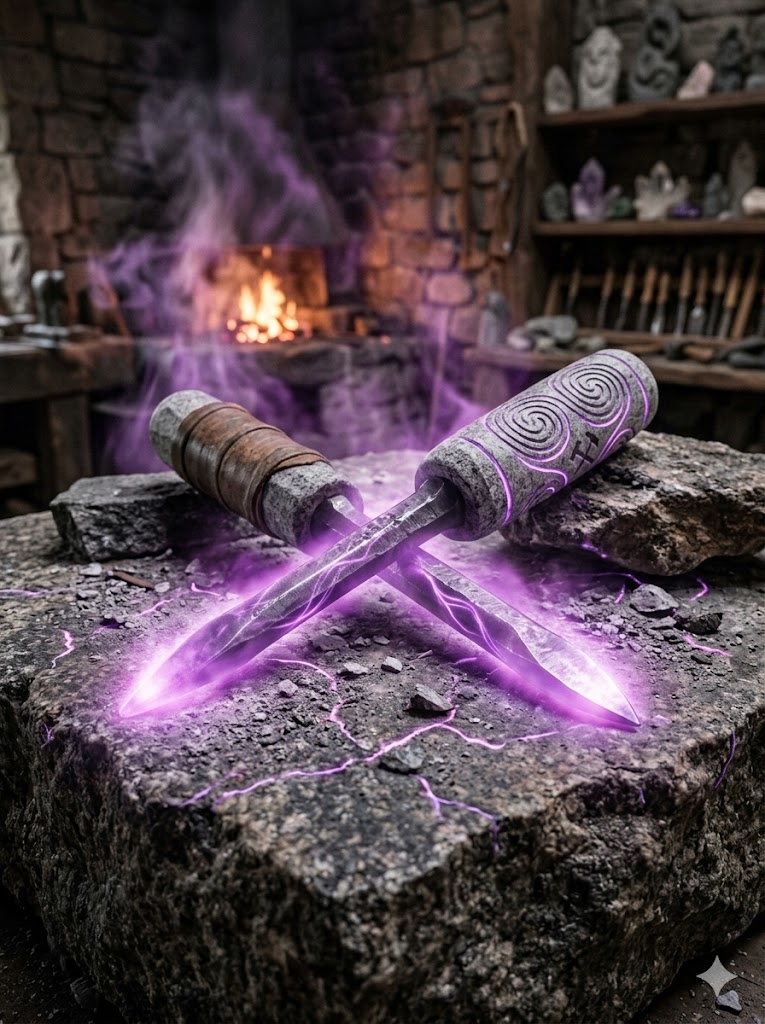
god given 418 of The Whispering Chisel
From: Abbevillianism The Faith of Gravok Lore In the industrial cliff-cities of Abbeville, not every creation is a towering golem or a fortress wall. Young initiates often start their journey with a simple tool blessed at a Forge of Gravok. The Whispering Chisel is a mundane-looking implement that hums with a faint, grounding vibration. It…
-
National Map of Yayoi
The national map of Yayoi depicts an island nation designed with the precision of a Stone Garden, where the terrestrial landscape is harmonized with the hydraulic flow of the Path of Still Waters Rising. The island is divided into three primary administrative regions, separated by the Great Arteries (The Roads of the Three Depths) that…
-
National Map or Yangshao
The national map of Yangshao illustrates a civilization defined by the “Lanes of the Potter,” where the primary infrastructure mirrors the geometric precision of the Linghua Script. The island is roughly organized into three massive administrative “Kiln-Districts,” separated by the Great Roads that radiate from the heart of the island. The Three Sovereign States (Kiln-Districts)…
-
National Map of Villanovan
The national map of Villanovan depicts a verdant, biologically integrated island of ~97,241,239 acres. The geography is defined by “The Crown’s Reach,” a series of massive, raised stone highways lined with bioluminescent flora and statues of the Matron-Queens. These roads serve as the political and ecological dividers for the three sovereign states of the nation.…
-
National Map of Urnfield
The national map of Urnfield depicts a rugged, industrialized island of ~101,000,000 acres, organized into a series of defensive “Ember-States.” The landscape is defined by the Three Great Arteries, massive bronze-paved highways that radiate from the central capital, serving as both the economic lifelines and the political boundaries of the nation. The Three Ember-States The…
-
National Map of Trypillya
The national map of Trypillya depicts a sprawling island nation of 92,623,768 acres, characterized by its unique “Loomed” geography. The island is structured around three massive Loomscript Arteries—ancient, glowing highways inscribed with golden protective runes. These roads radiate from the central capital and serve as the official borders for the nation’s three primary administrative states.…
-
National Map of Thule
The national map of Thule depicts a rugged, frost-rimmed island nation of approximately 90,314,824 acres. The geography is dominated by deep, glacier-cut fjords, towering black-stone cliffs, and a central highland massif. Three primary Iron-Rune Highways—massive, elevated stone roads reinforced with iron and inscribed with Skarvald protective runes—radiate from the central capital. These highways serve as…
-
National Map of Teotihuacán
The national map of Teotihuacán depicts a vast, ecologically diverse island nation of approximately 155,168,000 acres. The geography is defined by soaring volcanic peaks, tiered highland valleys, and a coastline punctuated by jade-green waters. Three massive Obsidian Processional Ways (grand, elevated highways inlaid with volcanic glass) radiate from the central capital, acting as the sacred…
-
National Map or Tayacian
The national map of Tayacian illustrates a sprawling, lush island territory of approximately 152,864,000 acres. The geography is dominated by a dense tropical interior and a coastline defined by intricate mangrove deltas and soaring cliffs. Three primary Horizon Highways (elevated stone and timber roads) radiate from the central capital, serving as the official administrative boundaries…
-
National Map of Tasian
The national map of Tasian depicts a vast, geologically active archipelago of approximately 151,852,110 acres. The island’s geography is defined by a massive central volcanic range and deep, tiered harbors. Three primary Magma-Roads (reinforced volcanic glass highways) radiate from the central capital, acting as the administrative boundaries for the nation’s three sovereign states. The Three…
-
National Map of Stillbay
The national map of Stillbay illustrates a massive island territory of approximately 155,100,000 acres, where the land is sculpted into a series of protective curves and fortified bays. Radiating from the geographic center are the three Royal Currents (primary trade roads), which serve as the formal administrative boundaries for the nation’s three constituent states. The…
-
National Map of Solutrean
The national map of Solutrean depicts a sprawling, rugged island of approximately 300,000,000 acres. The geography is dominated by a central glacial massif that feeds the island’s primary waterways. The three Imperial Stone-Ways (major roads) radiate from the central capital, acting as the formal administrative borders between the nation’s three states. The Three Administrative States…
-
National Map of Sangoan
The national map of Sangoan illustrates a massive island nation of 300,000,000 acres, where the land is a mirror of the sea’s fluid geometry. The three Grand Currents (the primary road networks) radiate from the central capital, dividing the island into three administrative states governed by the matrilineal monarchy. The Three Administrative States The major…