
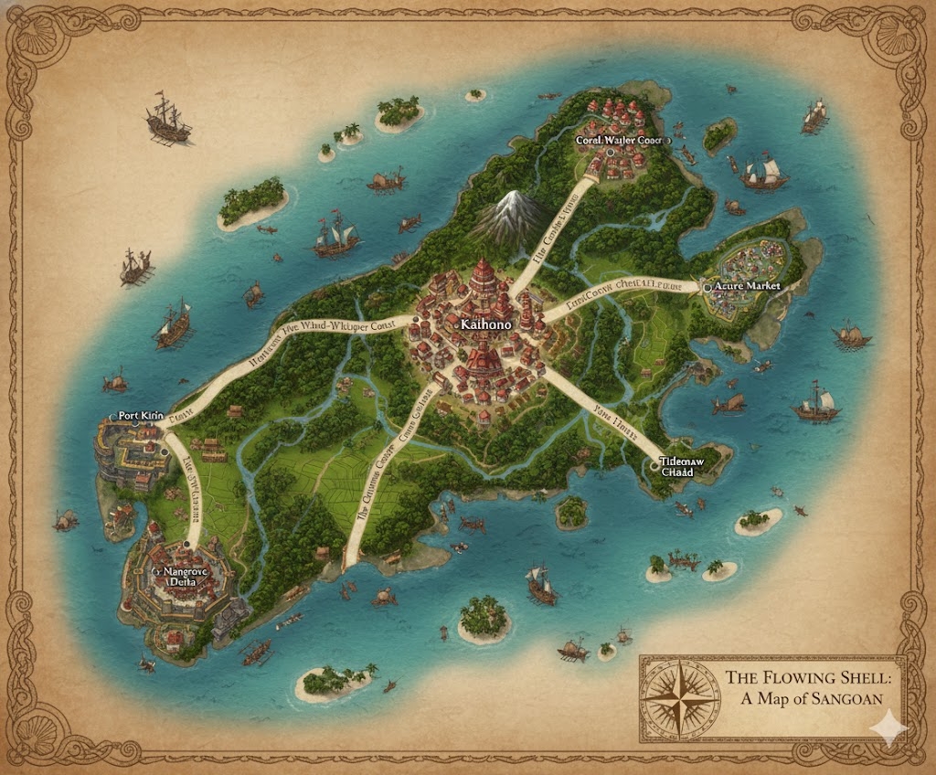
The national map of Sangoan illustrates a massive island nation of 300,000,000 acres, where the land is a mirror of the sea’s fluid geometry. The three Grand Currents (the primary road networks) radiate from the central capital, dividing the island into three administrative states governed by the matrilineal monarchy.
The Three Administrative States
The major roads act as the formal boundaries for the three provinces of the Sangoan realm:
- Atoll-Reach (North): The region between the North and West roads. It is a land of turquoise lagoons and expansive coral-ringed peninsulas, serving as the center for aquaculture and pearl harvesting.
- Volcanic-Ridge (East): The region between the North and East roads. This state encompasses the fertile volcanic highlands and dense tropical forests that provide the timber for the nation’s legendary shipyards.
- Mangrove-Delta (South): The vast southern expanse between the West and East roads. This state is a labyrinth of fertile coastal plains and deep mangrove channels, providing the nation’s rice surplus and strategic naval cover.
Major Cities of Sangoan
1. Kaihono (The Central Capital)
- Location: Built at the island’s geographic heart, where the three Grand Currents and the twin interior rivers converge.
- Description: Known as the “Heart of the Shell,” this megacity is built in a massive spiral. It features seashell-paved promenades, magically powered tide gates, and the Grand Shell Assembly—a palace shaped like a giant, glowing nautilus.
- Role: The seat of the Kaerunai monarchy and the spiritual center of the Tide of Ancestral Shells.
2. Port of the Rising Tide (Western Anchor)
- Location: The terminus of the Western Grand Current, situated on a deep-water bay.
- Description: A city of tiered wooden-and-stone terraces designed to move with the high-magic tides. It is famous for its floating market-ports where trade is conducted directly from ships to shore.
- Role: The primary naval fortress and gateway for trade with the island of Abbeville.
3. Coral-Gate (Northern Anchor)
- Location: Built at the tip of the northern peninsula, overlooking a massive natural coral reef system.
- Description: A city of “Living Architecture,” where buildings are woven from magically accelerated coral and reinforced with driftwood beams.
- Role: The center for marine research and the primary refinery for Nacre-infused magical gear.
4. Reef-Watch (Eastern Anchor)
- Location: Situated on the edge of the volcanic highlands where the eastern river meets the ocean.
- Description: A rugged city of stone and basalt, built to withstand the heavy tropical storms of the eastern sea. It features tall lighthouse-beacons fueled by volcanic steam.
- Role: The manufacturing hub for Sangoan shipyards and the primary export point for highland timber.
Points of Interest and Commerce
- The Twin Rivers (The Arteries of the Soul): These two major rivers flow from the central mountains to the southern coast. They are crowded with Reel-Barges—low-profile, double-hulled vessels that transport rice and tropical fruits. Commerce here is driven by the rhythmic Ruanikai fishing chants used to synchronize rowing and work crews.
- The Grand Currents (Roads): These are not merely roads but paved embankments that also act as irrigation dikes. They are wide enough for heavy caravans and are lined with shrines where travelers offer polished shells for safe passage.
- The Moon-Shell Lagoons: A cluster of bioluminescent lagoons in the north that glow during the lunar equinox. They are a site of national pilgrimage during the Moon-Shell Tide festival.
- The Silent Mangroves: A massive natural resource zone in the south rich in magical biodiversity. It is a “Living Lab” where Sangoan scholars study the intersection of saltwater and terrestrial magic.
- The Storm’s Rest Beacon: A massive, magically stabilized tower on the southern tip of the island that uses harmonic resonance to dampen incoming magical storms, protecting the southern agricultural plains.
This map portrays a nation that views the land as a “Great Shell,” a protected and perfectly engineered environment that sustains its 78.7 million souls through a balance of tradition and hydraulic magic.
The map of Sangoan is a blueprint of a civilization that lives in harmony with the sea’s pulse. The 300,000,000 acres of the nation are managed as a massive hydraulic machine, where every secondary community and trade lane serves the “Shell” of the central monarchy.
Secondary Communities: The Specialized Anchors
While the megacities handle the Grand Assembly and major exports, the following smaller communities sustain the nation’s infrastructure:
- Atoll-Hamlets (The North): Small, circular villages built on floating reed-and-coral platforms within the northern lagoons. These are the primary sites for Pearl-Seeding and the cultivation of edible sea-moss.
- Ridge-Watch Villages (The Highlands): Perched on the slopes of the volcanic interior, these communities manage the Mist-Collectors—massive nets that harvest water from the clouds to feed the high-altitude waterfalls and interior rivers.
- Mangrove-Outposts (The South): Hidden, stilted villages within the southern deltas. These act as the “Nursery Guards,” protecting the spawning grounds of the fish and crustaceans that feed the 78.7 million inhabitants.
- Tide-Station Hamlets: Located along the Grand Current roads, these communities maintain the massive sluice gates and dikes that prevent saltwater intrusion into the rice terraces.
Trade Routes: The Paths of the Ancestors
Commerce in Sangoan is defined by the Ruanikai concept of “Fluid Motion.” Goods move via three primary methods:
- The Grand Currents (Terrestrial): These raised embankments serve as the nation’s primary roads. They are paved with a mixture of crushed shell and lime, which glows faintly at night. Lithe Kaerunai trade-caravans use high-wheeled carts to transport textiles and alchemical glass across the island.
- The River-Spirals (Fluvial): The twin interior rivers act as high-speed conveyors. Because Sangoan engineering has perfected “Tide-Regulation,” the rivers can be made to flow inward or outward depending on the time of day, allowing Heavy-Log Rafts and grain barges to move with minimal effort.
- The Lagoon-Lanes (Maritime): Small outrigger canoes and “Glider-Boats” navigate the shallow waters between the coastal cities. These routes are marked by Buoy-Shrines that emit harmonic hums to guide sailors through the dense morning mists.
Natural Resource Zones: The Tides of Wealth
The terrain is partitioned into ecological zones that provide the raw materials for Sangoan’s high-magic society:
- The Nacre-Banks: Extensive shallow-water zones where the “Ancestral Shells” are harvested. The calcium and minerals from these shells are used to create the white cement for the roads and the material for high-tier Pearlskin armor.
- The Teak-Heights: High-altitude volcanic forests where the wood is naturally infused with mineral-rich steam. This wood is incredibly dense and rot-resistant, making it the only material used for the hulls of the Royal Navy.
- The Rice-Terraces: Thousands of acres of stepped fields on the southern plains. These are managed by Water-Priests who use Ruanikai chants to synchronize the flooding and draining of the fields according to the lunar cycle.
Terrain and Geological Features
- The Basalt Pillars: Found primarily in the East, these vertical rock formations act as natural windbreaks, protecting the inland valleys from the force of the seasonal storms.
- The Blue Holes: Deep, vertical underwater caves within the northern lagoons. These are considered sacred “Eyes of Ulun-Kai” and are used for deep-sea meditation and the testing of specialized diving gear.
- The Fossil-Crest: A ridge of ancient, uplifted coral that runs through the center of the island. It is the source of the rare Crystal-Coral used in the construction of the Grand Shell Assembly’s glowing domes.
The map of Sangoan illustrates a world where geography is never static. Between the Kaerunai rulers on their tiered terraces and the Tier 1 foragers in the mangroves, the nation functions as a single, breathing organism.