
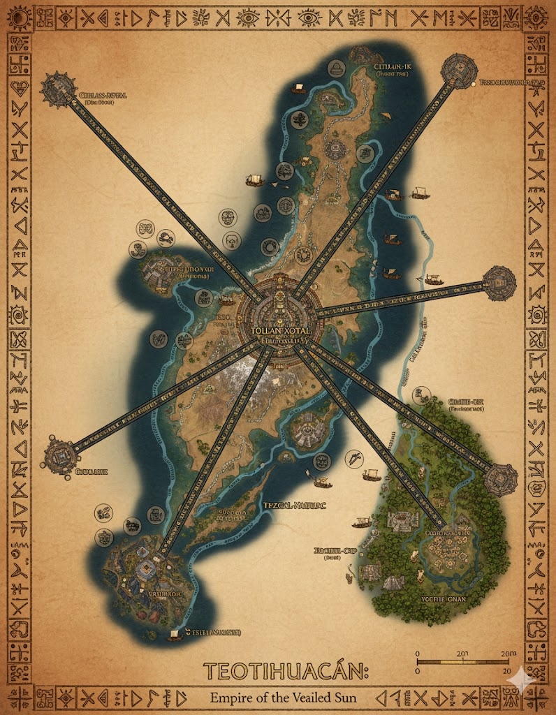
The national map of Teotihuacán depicts a vast, ecologically diverse island nation of approximately 155,168,000 acres. The geography is defined by soaring volcanic peaks, tiered highland valleys, and a coastline punctuated by jade-green waters. Three massive Obsidian Processional Ways (grand, elevated highways inlaid with volcanic glass) radiate from the central capital, acting as the sacred administrative boundaries for the nation’s three sovereign states.
The Three Administrative States
The major roads serve as the legal and spiritual dividers of the empire:
- Xotal-North: The region between the North and East Processional Ways. This is the industrial and mining heartland, containing the most active volcanic slopes and the primary sources of the nation’s high-quality obsidian.
- The Solar West: The region between the North and West Processional Ways. Known for its “Eternal Spring,” this state is the agricultural breadbasket, featuring the most advanced aqueduct systems and highland terraces.
- The Shadowed South: The region between the West and East Processional Ways. This state encompasses the dense, humid jungles and the major river deltas, acting as the center for exotic trade and rare botanical research.
Major Cities of Teotihuacán
1. Teotl-Grandeur (The Central Capital)
- Location: Built upon a massive plateau in the island’s center, surrounded by three dormant volcanoes.
- Description: A megacity of colossal step-pyramids and grand avenues. The Great Pyramid of the Hidden Face stands at its center, its gold-gilded summit visible from the highways leagues away.
- Role: The seat of the Matrilineal Monarchy and the High Priesthood. It is the center of all Nahualté scholarship and the site of the most prestigious “Tournament of Radiant Strikes.”
2. Port Obsidian (Northern Anchor)
- Location: Situated on a rugged northern coastline where volcanic cliffs meet the sea.
- Description: A city carved directly into basalt rock. Its harbors are lined with polished obsidian tiles that reflect the sunset, creating the famous “Burning Bay” effect.
- Role: The primary naval base and the hub for the export of raw volcanic minerals and enchanted stone carvings.
3. Jade-Haven (Western Anchor)
- Location: Located on a lush, sunlit coastal plain protected by a series of barrier islands.
- Description: Known for its “Floating Gardens” and architecture heavily decorated with green jade and Tlachiglyphs.
- Role: The center for maritime trade and the primary gateway for foreign diplomatic missions. It is famous for its markets of enchanted jade and fine silk.
4. Xochil-Delta (Eastern Anchor)
- Location: Built where the Great Serpent River meets the eastern ocean through a complex network of mangroves.
- Description: A city of canals and water-temples. The buildings are constructed on massive stone piles to withstand the seasonal river surges.
- Role: The heart of riverine commerce and the primary processing center for jungle-grown medicines and “Cinnabar-Pepper.”
Points of Interest and Commerce
- The Serpent Veins (Major Rivers): These wide, deep rivers flow from the highland glaciers to the coast. They are filled with Stone-Hulled Barges transporting massive blocks of carved stone and agricultural abundance. Commerce is governed by the “Rite of Seven Waters,” ensuring all river communities share the river’s wealth.
- The Obsidian Processional Ways: These are more than roads; they are ritual conduits. Every league is marked by a Mirror-Shrine where travelers can offer prayers to Xotalzin. The roads are built with a slight incline to assist the “Obsidian-Drays” (heavy cargo platforms) in their descent to the ports.
- The Aqueduct Spires: Located in the Solar West, these massive stone towers lift water from the mountain lakes and distribute it across hundreds of miles of agricultural terraces through gravity-fed channels.
- The Valley of Echoing Glyphs: A sacred canyon where the wind, passing through naturally perforated rock formations, produces tones that mimic the Nahualté language. It is a site of deep pilgrimage for poets and mages.
- The Lunar Observatories: Situated on the high, dry plateaus of the North, these temples track the celestial cycles to calibrate the Teotihuacán Ceremonial Almanac.
This map illustrates a civilization that views order, beauty, and celestial alignment as the highest virtues—a nation where every road and river is a deliberate stroke in a grand, living masterpiece.
The map of Teotihuacán reveals a landscape where the 155,168,000 acres are treated as a sacred geometric grid, balancing the raw power of the volcanic highlands with the lush fertility of the coastal plains. The terrain is a vertical journey, moving from the steam-heavy jungles to the thin, cold air of the obsidian peaks.
Secondary Communities: The Pillars of the Empire
While the major anchors handle the high administration, these specialized Tier 2 and Tier 3 communities are the lifeblood of Teotihuacán’s daily stability:
- The Observatory Hamlets (Highland Plateaus): Located on the dry, northern ridges where the air is clearest. These small, quiet communities are inhabited by Cycle Keepers and astronomers. They live in low, circular stone dwellings designed to minimize light pollution, ensuring the Ceremonial Almanac is updated with second-by-second precision.
- The Quarry-Holds (Xotal-North): Carved into the mid-slopes of active volcanoes. These are rugged, industrious towns where Ocelomé miners use ritual vibration-magic to fracture basalt and obsidian without causing landslides. The architecture here is “Explosion-Resistant,” featuring thick, slanted walls of reinforced stone.
- The Aqua-Vines (Solar West): These communities are built directly onto the massive aqueduct bridges. Residents manage the sluice gates and filtration systems that feed the nation. They are famous for their “Vertical Orchards,” where fruit trees are grown in stone pockets along the sides of the aqueducts.
- The Silt-Gatherer Camps (Shadowed South): Temporary but vital settlements that follow the seasonal retreat of the Great Serpent River. They harvest the mineral-rich black mud deposited by the floods, which is highly sought after as a magical catalyst for soil enrichment.
Trade Routes: The Pulsing Arteries
In Teotihuacán, trade is not just economic; it is a ritual procession that honors the movement of the sun:
- The Obsidian Processional Ways (Highways): These three elevated roads are the primary trade conduits. Their surface is composed of “Traction-Inlaid Glass”—obsidian that provides grip for the heavy paws of Ocelomé runners and the stone wheels of heavy drays. At night, the highways glow faintly from embedded bioluminescent lichen, guiding caravans through the dark.
- The Serpent Veins (River Commerce): The rivers are the “Downhill” routes. Massive Stone-Hulled Barges use the natural current to carry heavy ores and timber from the interior to the coast. To return upstream, these vessels utilize “Steam-Casters”—mages who boil the river water behind the boat to create localized jet-propulsion.
- The Sky-Lines (Mountain Transit): In the steepest regions of the Xotal-North, heavy goods are moved via massive stone buckets suspended on enchanted copper cables. These Sky-Lines allow the transit of minerals across canyons that would take days to traverse on foot.
Natural Resource Zones: The Trophies of the Land
The monarchy maintains a “Dual-Yield” policy, ensuring that for every resource taken, a ritual of restoration is performed:
- The Cinnabar Canyons: Located in the deep south, these red-walled gorges are the primary source of the pigments used in Tlachiglyph painting and the “Cinnabar-Pepper” spice. The air here is thick with aromatic heat, and the region is strictly protected by elite jungle guards.
- The Jade Shelves: Underwater limestone ridges along the Solar West coast. Here, divers harvest “Mana-Veined Jade,” a rare stone that naturally stores magical energy. This jade is essential for the construction of high-tier armor and monarchical focus items.
- The Sun-Grass Prairies: Found on the transitional slopes between the mountains and the plains. This unique grass absorbs solar energy during the day and is harvested to be woven into “Light-Thatch” for roofs, which keeps homes warm and illuminated throughout the cold highland nights.
Terrain and Geological Profile
- The Solar Shield: The central plateau is tilted slightly toward the south, ensuring it receives maximum sunlight for the Great Pyramid of the Hidden Face. This geological tilt is believed to be the result of a divine strike from Huizcātl’s shard in the First Age.
- The Glass-Folds: In the Xotal-North, centuries of lava flows have created “Glass-Folds”—natural tunnels of obsidian and basalt. These are used as cool, secure storage for the nation’s grain reserves and as hidden transit routes for the military.
- The Mist-Curtains: A permanent weather phenomenon in the Shadowed South where the warm jungle air meets the cold river water, creating a dense, iridescent fog. This mist is considered sacred and is used by priests to perform “Cloud-Scrying” for the Queen.
The map of Teotihuacán illustrates a nation that has mastered its environment through a combination of engineering genius and spiritual devotion. Every community, route, and resource is a part of the “Great Weaving” that keeps the island in harmony.