
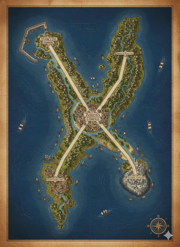
The national map of Tayacian illustrates a sprawling, lush island territory of approximately 152,864,000 acres. The geography is dominated by a dense tropical interior and a coastline defined by intricate mangrove deltas and soaring cliffs. Three primary Horizon Highways (elevated stone and timber roads) radiate from the central capital, serving as the official administrative boundaries for the nation’s three primary states.
The Three Administrative States
The major roads act as the geometric dividers of the land:
- Zuhuyá-North: The region between the Northern and Eastern Horizon Highways. This state is the spiritual and academic heart of Tayacian, containing the oldest jungle-temple ruins and the highest density of Horizon Houses.
- The Emerald West: The region between the Northern and Western Horizon Highways. This is the agricultural powerhouse, dominated by highland terraces and the harvesting of rare hardwoods.
- The Azure South: The region between the Western and Eastern Horizon Highways. This state is the naval and industrial center, managing the nation’s largest fisheries and the most complex mangrove trade networks.
Major Cities of Tayacian
1. Kohat-Prime (The Central Capital)
- Location: Situated at the absolute center of the island, nestled between the Great River and the central jungle highlands.
- Description: A massive megacity famous for its “Sail-Topped” skyscrapers that pivot to catch the wind for cooling. It is a multicultural hub where the Ka’ruháni royal court resides.
- Role: The political and linguistic heart of the nation. It houses the Lacquered Driftwood Archives, containing over two millennia of Kohatlé history.
2. Dawn-Edge (Northern Anchor)
- Location: Perched on the highest northern headlands overlooking the open sea.
- Description: A city of white stone pavilions and vertical docks. It is home to the Great Horizon House, the premier temple of Zuhuyá.
- Role: The center for advanced navigation and meteorological study. It is the first city to greet the sun each day.
3. Mist-Reach (Western Anchor)
- Location: Built where the western highland rivers meet the coast in a series of dramatic waterfalls.
- Description: Known for its “Tiered Markets,” where goods are transported between levels via water-powered lifts and ziplines.
- Role: The primary export hub for medicinal plants, rare fungi, and mountain-grown grains.
4. Tide-Grip (Eastern Anchor)
- Location: A fortified city integrated into a vast mangrove delta on the eastern shore.
- Description: A city of canals and floating plazas. The architecture is designed to rise and fall with the spring tides.
- Role: The headquarters of the Tayacian Merchant Fleet and the primary shipyard for the nation’s most elite trading vessels.
Points of Interest and Commerce
- The Veins of Tayacian (Major Rivers): These wide, deep rivers flow from the central highlands to the sea. They are the primary arteries for Jungle-Barges, which carry hardwoods and luxury crops. Commerce is heavily regulated by “River-Wardens” who use Kohatlé mnemonic chants to navigate the shifting silt-banks.
- The Horizon Highways: These are not mere roads but elevated causeways that protect travelers from the jungle’s humidity and predators. They are wide enough for two large trade caravans and are marked with Veyu-Koh runes every league to assist with orientation.
- The Mangrove Labyrinths: Located near Tide-Grip, these are zones of extreme biodiversity. They serve as “Natural Customs Ports” where incoming goods are sorted before reaching the urban metropolises.
- The Silent Ruins: Ancient temple complexes hidden deep within the Zuhuyá-North jungles. They are sites of pilgrimage for “Edge Watchers” seeking ancestral knowledge.
- The Azure Depths: The coastal waters surrounding the southern tip, famous for the highest yields of “Horizon Shells,” used both as currency in some regions and as offerings to Zuhuyá.
This map depicts a nation that is constantly looking outward, with every road and river designed to pull the wealth of the interior toward the ever-shifting edge of the sea.
The map of Tayacian reveals a nation where the terrain is treated as a living script, with the 152,864,000 acres organized to maximize the flow of movement between the jungle heart and the salt-spray edges. The geography is defined by a “High-Low” duality—elevated highways and mountain terraces contrasting with deep mangrove deltas and river arteries.
Secondary Communities: The Specialized Outposts
Beyond the anchor megacities, the Tayacian landscape is supported by essential Tier 2 and Tier 3 communities that act as the nation’s “sinews”:
- Canopy-Hold Villages (Zuhuyá-North): These are vertical communities built into the crowns of massive mahogany and ironwood trees. Inhabited primarily by Ka’ruháni scholars and herbalists, they focus on harvesting rare medicinal fungi and “Sky-Silk” from jungle spiders.
- The Terrace-Towns (Emerald West): These settlements are carved directly into the slopes of the central highlands. They resemble green staircases, where each level is a managed ecosystem for grains or fruit. The inhabitants are masters of irrigation, using gravity-fed bamboo pipes to move water across miles of vertical terrain.
- Root-Cutter Hamlets (Azure South): Located deep within the mangrove deltas, these communities live on “Weave-Hulls”—floating platforms made of interwoven vines and treated timber. They harvest the salt-resistant mangrove wood used for ship keels and the red dyes prized by Tayacian weavers.
- The Way-Stations: Small, fortified towers located every twenty leagues along the Horizon Highways. These serve as resting points for caravans, weather-monitoring outposts for the Edge Watchers, and scent-marking stations for travelers.
Trade Routes: The Flow of the Horizon
Commerce in Tayacian is governed by the cultural maxim of moving with the current, not against it:
- The Horizon Highways (The Elevated Veins): These roads are the primary terrestrial trade routes. By elevating them above the jungle floor, the Tayacians avoid the seasonal floods and the most dangerous predators. Heavy Dray-Llamas and Ka’ruháni runners move bulk ores and luxury silks between the capital and the northern ports.
- The Serpent-Ways (The River Routes): The Great River and its tributaries are the cheapest way to move heavy timber and stone. Jungle-Barges are often equipped with retractable sails to catch the winds that funnel through the river valleys.
- The Zipline Networks: In the steep Western Highlands, the Tayacians use a sophisticated system of gravity-fed cables and counterweighted pulleys to lower crates of mountain produce directly to the river docks, bypassing days of trekking on foot.
Natural Resource Zones: The Three Pillars
The monarchy maintains a “Cycle of Harvest” that rotates usage of these zones to prevent depletion:
- The Hardwood Reserves: Massive tracts of old-growth forest in the North. Harvesting is a ritual act; for every ironwood tree felled for a ship’s mast, a “Seed-Prayer” is conducted to ensure a replacement is planted according to lunar alignment.
- The Silt-Delta Flats: These are the most fertile lands in the nation, located at the mouth of the southern rivers. The rich volcanic silt from the interior makes these areas ideal for the massive spice plantations that provide Tayacian with its most valuable export: “Cinnabar-Pepper.”
- The Pearl Shelves: Shallow coastal waters in the East where the “Horizon Shells” are cultivated. These shells are not just aesthetic; they are used in the construction of high-tier Sighting Disks and as focus items for auditory magic.
Terrain and Geological Features
- The Central Spine: A range of mist-shrouded mountains that serves as the island’s water tower. The peaks are often above the clouds, providing the “Sky-Rain” that feeds the rivers and keeps the jungles humid.
- The Barrier Cliffs: The northern coast is a wall of limestone and basalt, protecting the interior from the worst of the oceanic storms. These cliffs are where the most prestigious Horizon Houses are built, offering unobstructed views of the sea and sky.
- The Blue Mangroves: A unique ecosystem in the South where the trees have adapted to absorb minerals from the volcanic runoff, turning their leaves a deep, iridescent blue. This area is a natural labyrinth, providing a nearly impassable defensive barrier against naval invasion.
This map illustrates a civilization that is perfectly “aligned” with its environment. To a Tayacian, the jungle is not an obstacle, and the sea is not a void; they are both paths to be read, navigated, and mastered.