
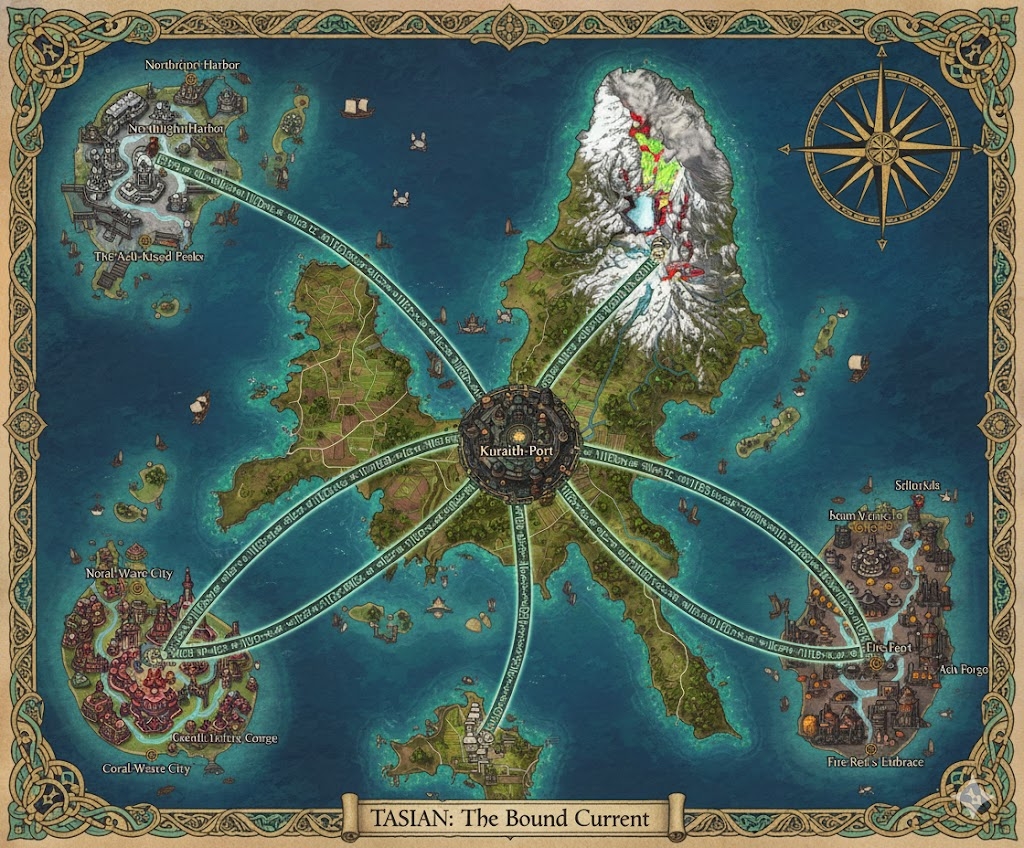
The national map of Tasian depicts a vast, geologically active archipelago of approximately 151,852,110 acres. The island’s geography is defined by a massive central volcanic range and deep, tiered harbors. Three primary Magma-Roads (reinforced volcanic glass highways) radiate from the central capital, acting as the administrative boundaries for the nation’s three sovereign states.
The Three Administrative States
The major roads serve as the legal borders for the provinces, each governed by a Matrilineal High-Steward:
- Vhoral-West: The region between the North and West Magma-Roads. Known as the “Cradle of the Current,” this state contains the lush tropical forests and the majority of the nation’s medicinal plant plantations.
- Kuraith-South: The expanse between the West and East Magma-Roads. This is the industrial heartland, dominated by active steam vents and black-sand beaches, specializing in geothermal energy and volcanic glass forging.
- The Eastern Reach: The region between the North and East Magma-Roads. This state encompasses the most treacherous reef belts and is the primary center for pearl diving and deep-sea navigation training.
Major Cities of Tasian
1. Kuraith’s Crown (The Central Capital)
- Location: Built directly onto the caldera of a dormant (but steaming) volcano at the island’s center.
- Description: A sprawling megacity of tiered white stone and coral. It features the Grand Steam-Fountain Plaza, where communal bathing and political debate occur simultaneously.
- Role: The seat of the Sea-Born Monarch and the center of Khilassan education. All official maritime laws and “Vibration Records” are housed here in glass-vaulted archives.
2. Port Vesh (Northern Anchor)
- Location: Situated in a massive natural basin on the northern coast.
- Description: Famous for its “Floating Markets” and coral-built docks. The city is constructed to sway with the frequent seismic tremors of the northern fault line.
- Role: The primary gateway for foreign trade and the headquarters of the Tidesworn Accord’s high priesthood.
3. Obsidian Bay (Western Anchor)
- Location: Built along a shoreline of shimmering black sand and basalt cliffs.
- Description: A city defined by its dark, heat-resistant architecture. It is lit at night by the natural glow of nearby volcanic vents.
- Role: The center for Tasian defense and the primary manufacturing hub for Steam-Wrought gear and ceremonial obsidian armor.
4. The Pearl Spires (Eastern Anchor)
- Location: Located on a series of interconnected coastal islands on the eastern edge.
- Description: A cluster of tall, slender towers built from white coral and reinforced with silver tide-nets.
- Role: The nation’s primary maritime research center and the heart of the pearl and rare-shell export industry.
Points of Interest and Commerce
- The Veins of the Deep (Major Rivers): These rivers are fed by underground springs and crater lakes. They are the primary arteries for Steam-Barges, which use geothermal heat to move bulk goods against the current. Commerce centers on the transport of tropical timber and volcanic minerals.
- The Magma-Roads: These highways are paved with “Vitreous Stone”—a type of volcanic glass that remains cool to the touch. They are inscribed with Vesh-Khil symbols to guide travelers and provide magical stability during earthquakes.
- The Steam-Vent Highlands: A central region where hundreds of natural vents release hot minerals. It is a sacred site for the Tidesworn Accord and a primary source of geothermal power for the capital.
- The Singing Reefs: Located off the eastern coast, these coral formations produce a harmonic hum when the tide passes through them. Kithrak navigators use these sounds to calibrate their directional gear.
- The Great Crater Lake: A massive body of water in the central highlands that serves as the nation’s primary freshwater reservoir and a retreat for the royal family.
This map portrays a nation in perfect, albeit precarious, balance—where every road, city, and river is designed to honor the “Sea and Stone” while harnessing the power of the island’s volcanic heart.
The geography of Tasian is a masterwork of “Seismic Resilience,” where the island’s 151,852,110 acres are meticulously managed to turn volcanic volatility into national wealth. The terrain is defined by the Tidesworn Accord’s philosophy: the land and sea are not rivals, but keepers of each other’s strength.
Secondary Communities: The Harmonic Outposts
While the megacities handle the Grand Assembly and high trade, these specialized communities provide the raw materials that fuel the Tasian economy:
- The Steam-Gardener Villages (Vhoral-West): Tucked into the lush slopes of the central volcanoes, these communities live in dwellings built into the roots of massive tropical trees. They use controlled steam from natural vents to create “Mist-Houses” for the cultivation of rare, heat-sensitive medicinal orchids and fungi.
- The Glass-Worker Holds (Kuraith-South): Located near the active lava flows, these Kithrak communities are experts in “Vitreous Shaping.” They harvest liquid stone directly from controlled vents to create the cool-touch volcanic glass used for the Magma-Roads and high-tier ceremonial gear.
- Reef-Anchor Hamlets (Eastern Reach): Semi-submerged villages built upon the “Singing Reefs.” These communities act as the primary gatherers of pearl-nacre and rare bioluminescent algae. They are unique for their “Wave-Choral” architecture, where buildings are designed to vibrate in harmony with the tides.
- Silt-Miner Camps: Found in the narrow gorges of the interior, these transient communities harvest the nutrient-rich volcanic silt deposited after seasonal floods, which is then transported to the coastal plains to fertilize the rice and spice fields.
Trade Routes: The Veins of Steam and Glass
Commerce in Tasian is a rhythmic cycle that moves goods with the efficiency of a breaking wave:
- The Magma-Roads (The Fixed Paths): These “Vitreous Stone” highways are the pride of the monarchy. Because the glass is magically cooled, it does not crack during tremors. Large, many-legged “Cinder-Drays” (heavy cargo walkers) transport raw obsidian and timber across the rugged interior.
- The Steam-Arteries (The Liquid Paths): The major rivers are essentially conveyor belts. Steam-Barges—vessels with reinforced metal hulls—use geothermal pressure to power internal paddles, allowing them to carry heavy stone blocks upstream against the current. The sound of their rhythmic steam-whistles is the heartbeat of Tasian commerce.
- The Canopy-Ziplines: In the steep, densely forested slopes of Vhoral-West, goods are often moved via gravity-fed cable systems. These are used for the rapid transport of fragile medicinal plants from the highlands directly to the river-ports.
Natural Resource Zones: The Gifts of Kuraith
The monarchy partitions the islands into zones that honor the balance of sea and stone:
- The Cinder-Plains: Vast stretches of black sand and volcanic ash. While they look desolate, they are the source of “Fire-Glass” minerals used in the forging of Tasian weaponry and the heat-resistant tiles that line the nation’s tiered harbors.
- The Deep-Current Kelp Beds: Located offshore in the Eastern Reach, these cold-water zones produce exceptionally strong sea-fibers. These fibers are woven into the “Moon-Cord” ropes used by shipwrights and ritualists alike.
- The Obsidian Flutes: A specific geological formation in the south where basalt columns have been hollowed by ancient gas vents. The wind here creates constant musical tones, and the stone harvested from this site is used to create “Echo-Stones” for long-distance seismic signaling.
Terrain and Geological Features
- The Smoking Crown: The central volcanic range is a constant source of both danger and energy. The constant plume of steam acts as a natural beacon for sailors hundreds of miles away.
- The Tiered Shelf: The coastline of Tasian is not a flat beach but a series of natural stone terraces. The Tasians have built upon these to create “Waterfall Cities,” where the overflow from interior springs cascades from one urban level to the next.
- The Saffron Gorges: Deep, orange-hued canyons in the interior created by mineral-rich floods. These gorges are natural wind-tunnels that the Kithrak use to test new sail designs and wind-based navigational gear.
The map of Tasian illustrates a civilization that treats its dangerous environment like a musical instrument—knowing exactly where to strike and where to listen to produce a state of perfect harmony.