
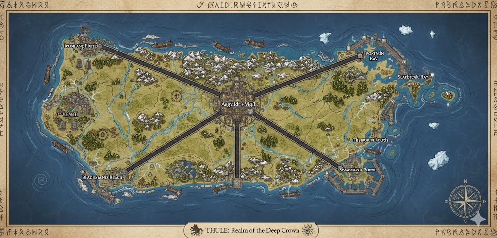
The national map of Thule depicts a rugged, frost-rimmed island nation of approximately 90,314,824 acres. The geography is dominated by deep, glacier-cut fjords, towering black-stone cliffs, and a central highland massif. Three primary Iron-Rune Highways—massive, elevated stone roads reinforced with iron and inscribed with Skarvald protective runes—radiate from the central capital. These highways serve as the official administrative boundaries for the nation’s three sovereign states.
The Three Administrative States
The major roads act as the tectonic dividers of the Thulian realm:
- Vardr-North: The region between the Northern and Eastern Iron-Rune Highways. This is the industrial powerhouse of Thule, containing the richest iron deposits and the primary black-sand foundries used for ship-plating.
- Frost-Reach West: The region between the Northern and Western Iron-Rune Highways. A land of snowbound ranges and fertile, glacier-fed valleys, it serves as the nation’s primary source of timber and cold-hardy livestock.
- The Storm-South: The region between the Western and Eastern Iron-Rune Highways. This state encompasses the most treacherous fjords and is the primary hub for naval training and deep-sea fishing expeditions.
Major Cities of Thule
1. Væstrvik-Prime (The Central Capital)
- Location: Situated on a high plateau at the confluence of the three Iron-Rune Highways, overlooking the Great Glacier River.
- Description: A fortress-megacity built into the basalt peaks. Its architecture is characterized by “Slope-Halls” that shed heavy snow and massive central braziers that provide heat to the urban tiers.
- Role: The seat of the Queen-Regent and the Circle of Helm-Bearers. It is the administrative heart where the Runasverd laws are etched into the city’s foundational “Oath-Pillars.”
2. Iron-Anchor (Northern Anchor)
- Location: Perched on the northernmost headlands, overlooking the ice-laden northern waters.
- Description: A city of soot-stained stone and glowing foundries. Its harbor is unique for its “Steam-Piers” that prevent the water from freezing, allowing year-round ship deployment.
- Role: The primary naval shipyard of Thule. This is where the Red Fleet was bound and where the nation’s most formidable war-galleons are forged.
3. Cliff-Grip (Western Anchor)
- Location: Built directly into the face of a 1,000-foot black-stone cliff overlooking the western sea.
- Description: A vertical city connected by massive exterior elevators and hanging bridges. Its buildings are bolted to the cliffside with titan-sized iron anchors.
- Role: The primary trade gateway to the western island nations and the headquarters for the Thulian Merchant Clans.
4. Tide-Breaker (Eastern Anchor)
- Location: Situated at the mouth of the deepest fjord on the eastern coast.
- Description: Home to the most prominent Root Sanctum, the city is famous for its “Drowned District”—a section of the city that is intentionally submerged during high tide to honor Aegvildr.
- Role: The spiritual center of the Deep Crown of Aegvildr and the primary site for the “Binding of the Red Fleet” ritual ceremonies.
Points of Interest and Commerce
- The Glacier Veins (Major Rivers): These rivers carry the “Blue-Melt” from the central highlands to the sea. They are the primary routes for Log-Barges, which transport the massive conifers from the interior forests to the coastal shipyards.
- The Iron-Rune Highways: These roads are engineered to remain clear of snow and ice through “Heat-Inlay” magic. They are wide enough for four heavy caravans and are guarded by Harbor Warden outposts every ten leagues.
- The Black-Sand Foundries: Massive industrial zones located along the coast between Vardr-North and Tide-Breaker. These foundries utilize the iron-rich sands to create the enchanted “Sea-Steel” that makes Thulian hulls nearly indestructible.
- The Sea-Wall Fortresses: A series of minor coastal outposts built along the Iron-Rune boundaries. They act as “Teeth” against sea-raiders, equipped with siege devices that launch Spears of the Frozen Current.
- The Standing Runestones: Scattered across the Highland Plains, these ancient markers act as navigational beacons for travelers and focal points for Skarvald incantations during the season of storms.
This map illustrates a nation that has mastered the cold and the sea, turning a harsh environment into a fortified, prosperous empire bound by iron, salt, and oath.
The map of Thule reveals a land where the 90,314,824 acres are defined by “The Grip”—the physical and spiritual effort required to hold the land against the crushing weight of ice and the erosion of the sea. The terrain is a vertical and jagged hierarchy, where life clusters in the sheltered fjords and along the iron-veined highways.
Secondary Communities: The Wardens of the Wild
While the megacities handle the high command, these specialized outposts ensure the empire’s resource security and territorial integrity:
- The Sledge-Towns (Highland Plains): Mobile communities of Thulian Humans who follow the migrations of the great walrus herds and cold-hardy beasts. They live in reinforced wooden longhouses mounted on massive iron runners, moving between the standing runestones that mark safe paths through the snow.
- The Foundry-Holds (Vardr-North): Subterranean industrial towns built directly beneath the black-sand beaches. These communities are dominated by the smoke of “Skarvald-Fire” furnaces, where the sand is purified into Sea-Steel. The workers here are renowned for their heat-resistant leather gear and rhythmic hammersmithing chants.
- Ice-Watch Villages (Frost-Reach West): Perched on the edges of the northern glaciers, these outposts monitor the “Blue-Melt” and the movement of icebergs. They use long-range Runasverd mirrors to signal the coastal ports about incoming ice hazards or “Feral” beast movements from the conifer forests.
- The Kelp-Farms (Storm-South): Semi-submerged settlements located in the shallower, warmer pockets of the southern fjords. These communities harvest the ice-spined kelp and seal sinew used in the creation of Deep Crown religious offerings and maritime ropes.
Trade Routes: The Iron and the Ice
Thule’s trade is a battle of logistics against the elements, moving resources along “Cleared Veins”:
- The Iron-Rune Highways (The Lifelines): These elevated roads are the primary terrestrial trade routes. The “Heat-Inlay” enchantments prevent snow accumulation, allowing heavy Steam-Wagons to transport refined iron and timber year-round. These roads are the only reliable way to move bulk goods across the treacherous highland massif.
- The Glacier-Melt Runs (River Trade): During the “Warming” season, the Glacier Veins become high-velocity transport routes. Log-Barges—massive rafts of conifer timber—are guided downriver by “Pole-Wardens” who use Skarvald wind-chants to keep the rafts from splintering against the riverbanks.
- The Fjord-Lanes: The deep-water fjords act as natural “wet roads.” Coastal galleons move between the Crown Harbors, transporting “Sea-Steel” armor and dried fish. These lanes are strictly patrolled by the Drákoryn night-watch to prevent corsair infiltration.
Natural Resource Zones: The Bone of the Land
The monarchy maintains a “Sustenance Protocol,” ensuring that the extraction of resources is balanced with the maintenance of the island’s geological roots:
- The Black-Sand Shelves: Located along the northern and eastern coastlines, these beaches are the source of Thule’s iron-rich sand. The harvesting is timed with the low tides, where laborers use enchanted sieves to separate the metal from the salt.
- The Conifer Deep: Dense forests in the West that produce “Storm-Wood”—timber that has survived centuries of high-altitude gales. This wood is exceptionally dense and is the only material used for the masts of the Queen’s War-Galleons.
- The Brine-Wells: Natural volcanic vents beneath the sea in the Storm-South. These vents produce highly concentrated salt and minerals used in the “Blood-Salt” binding rituals and for the preservation of meat for long naval voyages.
Terrain and Geological Profile
- The Basalt Spines: The island is geologically anchored by massive basalt ridges that run like “ribs” from the central capital to the coast. These ridges are the foundation for the Iron-Rune Highways and provide the stone for the Root Sanctums.
- The Blue-Ice Gorges: Deep canyons in the Frost-Reach West carved by ancient glaciers. The ice here is so old and compressed that it resonates with magical energy, often used by mages to create Spears of the Frozen Current.
- The Mist-Gates: Natural gaps in the coastal cliffs where the cold northern air meets the warmer harbor waters. These gates create a permanent fog used for the Horizon Veil enchantments, shielding Thule’s naval maneuvers from prying eyes.
This map portrays a nation that does not just live on the land, but within it—using iron, rune, and blood to anchor their civilization to the frozen stone of the world.