
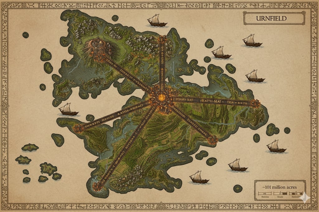
The national map of Urnfield depicts a rugged, industrialized island of ~101,000,000 acres, organized into a series of defensive “Ember-States.” The landscape is defined by the Three Great Arteries, massive bronze-paved highways that radiate from the central capital, serving as both the economic lifelines and the political boundaries of the nation.
The Three Ember-States
The major roads divide the island into three administrative territories, each governed by a regional Hearth-Lord:
- The Forged Marches (Northwest): Situated between the North and West Arteries. This is the industrial powerhouse of Urnfield, home to the deepest mines and the most intensive bronze-smelting operations.
- The Ash-Basin (Northeast): Located between the North and East Arteries. This region contains the most fertile agricultural terraces, enriched by millennia of ritual ash-burial. It is the nation’s “breadbasket.”
- The Hearth-Sands (South): The vast territory between the East and West Arteries. It features rugged coastal cliffs and long, winding river deltas, focusing on maritime defense and international trade.
Major Cities of Urnfield
1. Ember-Throne (The Central Capital)
- Location: The geometric center of the island, where the Three Great Arteries converge.
- Description: A massive, fortified megacity built in tiered circles around the Great Hearth-Hall. The city is constantly draped in a light veil of sacred woodsmoke from the eternal fires.
- Role: Seat of the Ash-Keeper (The Queen) and the site of the Great Jar. It is the heart of all civic and religious authority.
2. Bronze-Gate (Northern Anchor)
- Location: At the terminus of the North Artery, overlooking the storm-prone northern seas.
- Description: A fortress-city built into black basalt cliffs. Its walls are plated in enchanted bronze that glows with heat-distorted wards when under threat.
- Role: The primary naval shipyard and the main defense against northern sea-raiders.
3. Ash-Port (Eastern Anchor)
- Location: Situated where the East Artery meets the Great Slag River delta.
- Description: A sprawling commercial hub with massive stone docks and ceramic-lined warehouses. The city is famous for its “Potter’s Markets,” where ceremonial urns are traded.
- Role: The main gateway for food distribution and the export of Urnfield’s world-class metalwork.
4. Iron-Roost (Western Anchor)
- Location: At the western edge of the West Artery, bordering the high mineral-ridges.
- Description: Built primarily by the Drakurni, this city features architecture on a titanic scale. It is characterized by deep subterranean halls and massive lift-mechanisms.
- Role: The center of mining and heavy metallurgy. It is where the “Spirit-Bound” weapons for the military are forged.
Points of Interest and Commerce
- The Great Slag River: The island’s primary waterway, flowing from the central highlands to the eastern coast. It is constantly busy with Bronze-Barges—heavy, flat-bottomed vessels transporting raw ore, agricultural surplus, and massive quantities of ritual clay.
- The Burial Terraces: Stretching across the Ash-Basin, these wide, stepped hills are dotted with “Urn-Shrines.” They are not just cemeteries but active farmland, where the spirits of ancestors are believed to guard the crops.
- The Road of Whispers (West Artery): A section of the road known for its bone-conduction resonance. Drakurni travelers can “hear” messages sent through the road’s foundation from the capital over fifty miles away.
- The Ever-Smoke Towers: Located along the northern coast, these monumental chimneys release colored smoke to signal shipping lanes or warn of incoming storms, utilizing the Karnathi code of signals.
- The Smith-Lord’s Quarry: A massive open-pit excavation site in the northwest where the “Living Stone” for the capital’s foundations was first harvested. It now serves as a training ground for war-mages practicing earth-to-bronze transmutations.
This map illustrates a nation that has mastered the elements of earth and fire, creating a landscape that is both a fortress for the living and a sanctuary for the dead.
The map of Urnfield reveals a landscape where the 101,000,000 acres are treated as a vast, interconnected furnace. The terrain is a geological paradox—rugged, volcanic highlands in the west transition into meticulously terraced “Cemetery-Fields” in the east, all unified by the heat of the central capital.
Secondary Communities: The Keepers of the Chain
While the major cities handle the high governance and heavy industry, these specialized Tier 2 and Tier 3 communities maintain the nation’s spiritual and logistical foundations:
- The Kiln-Hamlets (The Ash-Basin): Small, circular villages located in the agricultural heartland. These communities are centered around communal “Life-Kilns” where family pottery is fired. The residents are master ceramicists who produce the specialized urns for the nation’s burial rites.
- The Sentry-Roosts (Northwestern Marches): Vertical outposts carved into the basalt ridges between the Drakurni mines. These communities house the Drakurni Border-Watch, who use their bone-conduction hearing to monitor the subterranean foundations of the island for stability and intruders.
- The Silt-Gatherer Camps (The Hearth-Sands): Temporary but vital settlements at the river deltas. They harvest the mineral-rich “River-Ash”—volcanic sediment washed down from the highlands—which is highly prized as a fertilizer and a magical catalyst for bronze-alloying.
- The Way-Hearth Inns: Located at regular intervals along the Three Great Arteries. These are fortified rest stops where the “Ever-Flame” is kept burning in a public brazier, allowing travelers to rekindle their personal hearth-charms.
Trade Routes: The Bronze and the Slag
Commerce in Urnfield is driven by the movement of heavy materials, utilizing the “Path of the Flame” to ensure efficient transit:
- The Three Great Arteries (Terrestrial Flow): These bronze-paved highways are the primary trade conduits. Because they are engineered with “Heat-Resonance,” snow never settles on them, allowing massive Drakurni-led Caravans to transport refined ingots and stone blocks regardless of the season.
- The Great Slag River (Aquatic Flow): The river acts as a heavy-load conveyor. Bronze-Barges—vessels with metal-reinforced hulls—use the natural current to carry raw ore from the highlands to the eastern ports.
To return upstream, these barges utilize “Steam-Towers” located at locks, where mages boil water to create pressurized jets that push the barges against the current.
- The “Shadow-Lanes”: These are the subterranean tunnels and mine-shafts that connect the mountain cities. Primarily used by the Drakurni, these routes allow for the secure movement of military supplies and “Spirit-Bound” weaponry beneath the surface of the island.
Natural Resource Zones: The Blood of the Earth
The monarchy maintains strict control over the “Elemental Veins,” ensuring that every extraction honors the goddess Varestris:
- The Obsidian Scars: Deep gorges in the northwest where high-quality volcanic glass is harvested. This obsidian is essential for the creation of “Ash-Script” styluses and the mirrors used in temple divinations.
- The Cinnabar Terraces: Located on the lower slopes of the central mountains. The red pigment harvested here is used for the “Ember-Red” funerary cloths and as a flux in high-tier bronze forging.
- The Clay-Beds of Thurnas: Vast pits of fine-grain, grey clay located in the Ash-Basin. This clay is considered a sacred resource, as it is the only material approved for the creation of royal burial jars.
Terrain and Geological Profile
- The Basalt Ribs: The island is geologically reinforced by massive ridges of basalt that fan out from the central capital. These ridges act as natural walls, protecting the interior agricultural basins from the fierce northern sea-winds.
- The Ash-Plains: Centuries of ritual cremations and volcanic activity have created a layer of dark, mineral-heavy soil. This terrain is exceptionally stable and fertile, though it requires constant irrigation from the Great Slag River.
- The Steam-Vents: Located primarily in the southern Hearth-Sands, these natural geothermal vents are used by secondary communities to power public laundries, bathhouses, and small-scale forging kilns without the need for additional fuel.
The map of Urnfield illustrates a nation that has integrated its history into its very soil, using fire and bronze to forge a landscape that is as much a monument as it is a home.