
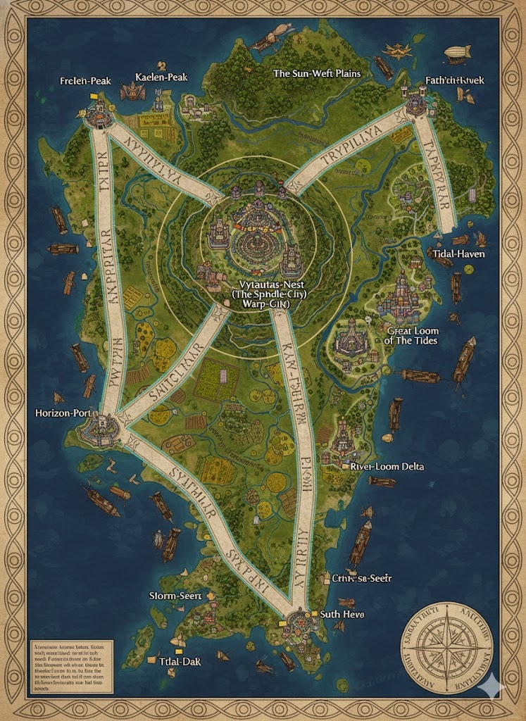
The national map of Trypillya depicts a sprawling island nation of 92,623,768 acres, characterized by its unique “Loomed” geography. The island is structured around three massive Loomscript Arteries—ancient, glowing highways inscribed with golden protective runes. These roads radiate from the central capital and serve as the official borders for the nation’s three primary administrative states.
The Three Sovereign States
The major highways divide the island into three distinct cultural and economic zones:
- The Golden Weave (Northeast): Located between the North and East Arteries, this state is the agricultural heartland. It is dominated by vast, patterned fields of flax and “Moon-Grain,” where the soil is ritually plowed to follow the curves of the Loomscript roads.
- The Spindle-Peaks (West): The region between the North and West Arteries. This is a highland territory of wind-polished hills and sacred conifer belts. It is the primary source of the “Blessed Fibers” used in Trypillyan textiles and the timber for their airship docks.
- The Azure Fjord-State (South): Encompassing the territory between the West and East Arteries, this region is a complex network of sheltered inlets and river deltas. It is the hub of the nation’s maritime trade and maritime-enchanted pottery production.
Major Cities of Trypillya
1. Sky-Reach Oryn (The Central Capital)
- Location: The “Nexus Point” at the dead center of the island where the three Loomscript Arteries meet.
- Description: A vertical megacity built in concentric rings. It is dominated by the Grand Pattern Hall, a temple-structure so large its loom-towers are visible from miles away.
- Role: The seat of the Feather-Mother Dynasty (the Talon-Trypanik royalty). It is the center of the “Silent Loom Ceremony” and the origin point of all national magical currents.
2. Hryssa-Port (Northern Anchor)
- Location: Situated at the terminus of the North Artery on a jagged cliffside.
- Description: Known for its “Roost-Terraces,” this city is built to accommodate thousands of gliding Talon-Trypanik. The city’s walls are painted with massive spiraling motifs of the “Sky-Furrower.”
- Role: The primary defense hub against northern sea-threats and the center for “Air-Navigator” training.
3. Spindle-Hold (Western Anchor)
- Location: A coastal fortress-city where the West Artery meets the storm-battered western sea.
- Description: Architecture here is designed to “tune” the heavy western winds into harmonic tones that power the city’s industrial looms.
- Role: The center for “Gear-Crafting.” Every piece of clothing and tool produced here is inscribed with unique lineage marks during the Bond-Thread Festival.
4. Silk-Haven (Eastern Anchor)
- Location: A sprawling port-city at the mouth of the Great Serpent River on the eastern coast.
- Description: Famous for its “Water-Looms”—massive river-wheels that weave protective enchantments directly into the city’s aqueduct system.
- Role: The primary commercial gateway for international trade, specializing in the export of enchanted ceramics and sacred textiles.
Points of Interest and Commerce
- The Great Serpent River (Major River): This massive waterway bisects the Golden Weave. It is crowded with Sails-of-Linen—flat-bottomed merchant barges that transport raw flax and grain from the interior to Silk-Haven. The river’s banks are stepped in terraces to prevent erosion and maximize arable land.
- The Loomscript Arteries (Magical Highways): More than just roads, these are conduits for the nation’s mana. They are inscribed with gold-leaf runes that glow softly at night, providing light for travelers and a permanent Root-Binding Ward against hostile creatures.
- The Wind-Temple Amphitheaters: Located in the highland valleys of the West, these are natural stone formations where the Talon-Trypanik perform “Plume Rhetoric” ceremonies and call upon the Four Winds to bless the harvest.
- The Patterned Cliffs: Along the Southern fjords, the cliffs have been carved with mile-high depictions of the Sky-Feathered Watcher. These carvings act as “Horizon Veils,” making the island difficult to map accurately from the sea without royal permission.
- The Sun-Gate Arches: Massive stone arches built over the Loomscript Arteries at the entrance to each major city. During the Festival of Loomed Dawn, the sun aligns perfectly with these arches, “recharging” the defensive glyphs inscribed into the city walls.
This map reflects a civilization that has transformed its environment into a living tapestry, where the roads, rivers, and cities are all threads in a single, unbreakable national design.
The map of Trypillya reveals a land where the 92,623,768 acres are organized as if the island itself were a massive piece of fabric, with the landscape features serving as the “warp and weft” of the nation. The terrain transitions from high, wind-swept roosts to fertile, river-fed basins, all connected by the rhythmic flow of commerce and faith.
Secondary Communities: The Nodes of the Pattern
While the anchor cities manage the high governance, these specialized Tier 2 and Tier 3 communities act as the “knots” that secure the national weave:
- The Roost-Hamlets (Spindle-Peaks): Small, vertical villages built into the sheer faces of the western hills. Inhabited primarily by Talon-Trypanik gliders, these communities harvest “Sky-Moss” used for high-quality indigo dyes and act as a network of early-warning sentinels for the western coast.
- The Sluice-Towns (Golden Weave): Settlements built at the intersections of the secondary aqueducts. These communities manage the “Purification Runes” that ensure every patterned field receives magically treated water. The inhabitants are masters of ceramic pipe-making, producing the vessels for the nation’s water-borne enchantments.
- The Delta-Weave Camps (Azure Fjord-State): Seasonal communities that move with the shifting silt of the southern rivers. They harvest “Salt-Flax,” a rare aquatic plant whose fibers are essential for creating the waterproof sails used by the maritime fleet.
- Way-Station Shrines: Found at ten-league intervals along the Loomscript Arteries. These are not just rest stops but small spiritual centers where travelers can perform the “Thread Blessing” before continuing their journey.
Trade Routes: The Circulating Threads
Commerce in Trypillya follows the “Path of Least Resistance,” utilizing the natural wind currents and the gravity of the river systems:
- The Loomscript Arteries (Terrestrial Flow): These are the primary land routes. Because they are inscribed with Root-Binding Wards, they are the only paths safe for the transport of high-value “Loom-Stone” and royal artifacts. Heavy Ceramic-Plated Wagons move refined ores from the western hills to the central capital.
- The Great Serpent Veins (Riverine Flow): The river system acts as a downward conveyor. Sails-of-Linen—barges with massive, magically lightened sails—carry bulk grain and raw flax down toward the eastern ports. To return upstream, these barges utilize “Wind-Catchers,” mages who manipulate the thermal currents rising from the Golden Weave.
- The Glide-Lanes: In the Spindle-Peaks, the terrain is too broken for roads. Here, trade is conducted via “Glide-Carriers”—specialized Talon-Trypanik who use Wing Mantles to ferry light, high-value goods (like medicines and dyes) from roost to roost across the canyons.
Natural Resource Zones: The Dye and the Fiber
The monarchy maintains a “Sacred Reserve” policy, where certain zones are left wild to ensure the “natural threads” of the island are never fully unraveled:
- The Flaxen Prairies: Located in the Golden Weave, these are the most fertile lands on the island. The flax grown here is said to be “Sun-Drunk,” producing fibers that are naturally conductive to light-based magic.
- The Obsidian Gorges: Deep, narrow cuts in the western highlands. These are the primary sources of the black glass used for “Pattern Reading” mirrors and the sharp-edged tools required for precision weaving.
- The Indigo Marshes: Found in the lowlands of the Azure Fjord-State. These wetlands are the only source of the “Deep-Sea Snail” used to produce the Royal Indigo dye, a color reserved for the Feather-Mother lineage.
Terrain and Geological Profile
- The Wind-Polished Hills: In the West, the stone is smoothed into fluid, wave-like shapes by millennia of gales. These hills act as natural amplifiers for the Trypanik language, allowing ceremonial chants from the capital to be heard (as faint echoes) even at the western coast.
- The Stepped Terraces: Almost every slope in the Golden Weave has been artificially terraced. From the sky, these terraces look like the “Steps of a Loom,” creating a geometric beauty that also prevents the soil from washing away into the Serpent River.
- The Shimmer-Veins: Natural quartz deposits that run parallel to the Loomscript Arteries. These veins are believed to be the “First Threads” of Orynya, and they help stabilize the magical resonance of the highways.
The map of Trypillya portrays a civilization that has meticulously “dressed” its landscape, turning every natural feature into a functional part of the nation’s spiritual and economic tapestry.