
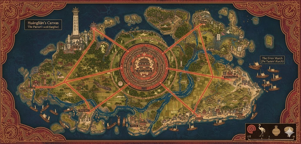
The national map of Yangshao illustrates a civilization defined by the “Lanes of the Potter,” where the primary infrastructure mirrors the geometric precision of the Linghua Script. The island is roughly organized into three massive administrative “Kiln-Districts,” separated by the Great Roads that radiate from the heart of the island.
The Three Sovereign States (Kiln-Districts)
- The Ochre Delta (East): Bordered by the North and South Arteries. This is the agricultural heartland, characterized by endless rice terraces and the mouth of the Red Serpent River.
- The Indigo Uplands (North/West): Bordered by the North and West Arteries. A region of high mountain passes and lacquerwood groves, home to the most secluded Zhaolun monastic orders.
- The Cinnabar Marches (South/West): Bordered by the West and South Arteries. A rugged terrain rich in mineral clays and stone quarries, focusing on the defense of the southern trade lanes.
Major Cities of Yangshao
1. Hearth-Peak (The Capital Megacity)
- Location: Situated at the absolute center of the island, built into the slopes of a dormant volcanic caldera.
- Description: A tiered city of white ceramic-washed walls and golden-tiled roofs. The Grand Kiln-House at its center houses the Sun Jar, an eternal flame visible from miles away.
- Role: The seat of the Matron-Queen and the center of Hualing scholarship. All roads lead here for the annual “Renewal of the Crown” ceremony.
2. Port of Whispering Reeds (The Eastern Gateway)
- Location: The terminus of the East Road, where the Red Serpent River meets the sea.
- Description: A city of canals and floating markets. Most buildings are adorned with blue-and-white mural patterns, reflecting its status as a hub for overseas trade.
- Role: The primary export point for Yangshao pottery and silken textiles. It is the first point of contact for foreign merchants.
3. Iron-Glaze Bastion (The Northern Port)
- Location: At the northern end of the North Artery, built onto wind-carved cliffs.
- Description: A fortress-city where the architecture is reinforced with “Living Metal” and dark-fired brick. It overlooks the northern beacon towers.
- Role: The center for military naval engineering and the training grounds for those who master Clay-Fired Judgment magic.
4. Azure-Tide (The Southern Hub)
- Location: Located at the southern tip of the South Artery, nestled in a protected sandy bay.
- Description: Famous for its “Twilight-Gazed” architecture, where windows are crafted from amber-glass to catch the setting sun.
- Role: The secondary mercantile hub, specializing in the harvesting of deep-sea minerals used in Zhaolun mineral treatments.
Points of Interest and Commerce
- The Red Serpent River: This massive waterway flows from the central mountains to the eastern coast. Commerce consists of Ceramic-Hulled Barges transporting grain, raw clay, and pigments. The river is meticulously managed by “Water-Turners”—mages who ensure the seasonal floods nourish the fields without destroying the towns.
- The Kiln of Ancestors: A massive, semi-subterranean structure in the Cinnabar Marches where the Shattering of the Vessel burial rites are performed on a national scale. The earth here is said to glow faintly at night with the collective “inner light” of the departed.
- The Lacquerwood Grove: A vast forest in the Indigo Uplands where the trees produce a resin that is naturally mana-conductive. Trade routes through these woods are protected by Vine-Bound Sanctuaries to prevent illegal harvesting.
- The Painted Terraces: Stretching for hundreds of miles along the Ochre Delta, these rice fields are planted in specific patterns that, when viewed from the Great Roads, form giant Linghua Script symbols of prosperity.
- The Pillar of the First Potter: A towering natural spire near Hearth-Peak where Huánglián is said to have first mixed her breath with the clay. It is the destination for the “Pilgrimage of the Worn Step.”
The map reveals a nation that is both a fortress and an art gallery, where every road, river, and terrace is a deliberate brushstroke on the canvas of Saṃsāra.
The map of Yangshao illustrates a nation of ~30,096,444 acres that functions as a living workshop. The terrain is defined by a central volcanic core that bleeds into fertile, sediment-rich river basins, all connected by “The Potter’s Path”—a logistical network that treats the movement of goods as a sacred ritual of transformation.
Secondary Communities: The Nodes of the Kiln
While the anchor cities serve as the cultural and political poles, these Tier 2 and Tier 3 communities act as the “joining seams” of the nation:
- The Glaze-Roosts (Indigo Uplands): High-altitude villages built into the limestone spires. These communities specialize in harvesting rare volcanic gases and mineral dust used to create the iridescent “Zhaolun Sheen” on high-end pottery.
- The Ochre-Silt Camps (Red Serpent Delta): Floating seasonal villages that move with the river’s tides. They are responsible for the ritual dredging of “First Clay”—the fine, mineral-rich sediment that is the only material permitted for royal Sun Jars.
- The Mulberry Groves (Southern Foothills): Communities dedicated to the cultivation of sacred mulberry trees. The bark and root fibers are harvested to create the “Binding Threads” used in ancient pottery rites and the silken paper for Linghua Script scrolls.
- Way-Heal Centers: Found at every major junction of the Great Arteries. These are communal hearths where travelers can perform “Wheel Chants” to restore their physical stamina and refresh the inner glow of their ceramic-like skin.
Trade Routes: The Flow of Form
Commerce in Yangshao follows the philosophy of “Measured Movement,” ensuring that goods are handled with the patience of an artisan:
- The Lanes of the Potter (Terrestrial): The Great Arteries are more than roads; they are paved in a ceramic-stone composite that minimizes the friction of the Zhaolun’s heavy bodies. Lattice-Wagons—automated frames that hook into a Zhaolun’s back-lattice—allow for the rapid transport of heavy stone and metal without tiring the driver.
- The Red Serpent Arteries (Aquatic): This is the primary route for bulk cargo. Ceramic-Hulled Barges move with the current toward the coast. Upstream travel is achieved through “Vibrational Tugging,” where mages on the banks use Earthen Resonance Wards to “pull” the water against the current in localized pulses.
- The Sky-Kite Corridors: During the Festival of Ten Thousand Wings, these high-altitude wind currents are used as temporary trade lanes. Light, high-value goods like concentrated mana-pigments are ferried via magically stabilized kites and gliders.
Natural Resource Zones: The Goddess’s Palette
The Matron-Queen manages the island’s resources through “Color-Rights,” ensuring that no pigment or clay is over-harvested:
- The Cinnabar Veins (Southwest): A network of deep, red-walled canyons. This is the only source of the deep-red ochre used in the “Festival of Dawn’s Breath.” The air here is thick with “Heart Scent” (xinwei), making it a popular site for Zhaolun meditation.
- The Lacquerwood Thickets (North): Forests of resinous trees that produce a sap so mana-dense it must be harvested with ceramic tools to prevent accidental ignition. This lacquer is the primary material for the “Armor of the Painted Dawn.”
- The Kaolin Basins: Located near the central caldera, these white-clay pits provide the raw material for the nation’s infrastructure. Every brick in the capital’s tiered districts can be traced back to a specific “Firing Line” within these basins.
Terrain and Geological Profile
- The Stepped Valleys: The transition from the central mountains to the plains is not a slope, but a series of “Divine Steps.” These artificial terraces prevent the Red Serpent from eroding the landscape and act as a massive, tiered Earthen Bastion against terrestrial invasion.
- The Glass-Fissures: In the Indigo Uplands, natural cracks in the earth emit a low, golden glow. These are believed to be the breath of Huángmǔ Zàohuà and are used by mages to “fire” large-scale enchantments without a kiln.
- The River-Veils: Constant mist hangs over the eastern deltas. This isn’t just weather; it’s a byproduct of the river’s high mana content. These mists are utilized in Shadow Dance magic to create city-wide illusions during the Sharus month.
The map of Yangshao presents a nation that treats its geography as a masterpiece in progress, where every community and trade lane contributes to the “Painted Dawn” of the civilization.