
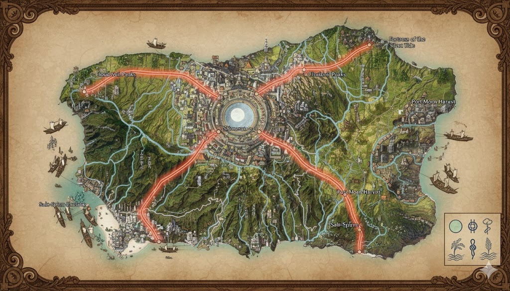
The national map of Yayoi depicts an island nation designed with the precision of a Stone Garden, where the terrestrial landscape is harmonized with the hydraulic flow of the Path of Still Waters Rising. The island is divided into three primary administrative regions, separated by the Great Arteries (The Roads of the Three Depths) that radiate from the central volcanic highlands.
The Three Sovereign Prefectures
- The Mirror Plains (East): Divided by the Northeast and Southeast Arteries. This region contains the most extensive rice terraces and serves as the nation’s primary food source.
- The Misted Shallows (South/West): Bordered by the Southeast and West Arteries. A region of coral-ringed lagoons and platform cities, where maritime trade is the primary focus.
- The Cedar Heights (North/West): Bordered by the West and Northeast Arteries. Dense with sacred forests and volcanic hot springs, this is the center of Yayoi’s woodcraft and spiritual retreats.
Major Cities of Yayoi
1. Mizuho-Kyo (The Capital Megacity)
- Location: Built at the island’s center, circling the base of the sacred volcanic peak where the first rain is said to have fallen.
- Description: A massive, tiered metropolis of white stone and dark cedar. It is a “City of Bridges,” with thousands of canals serving as the primary streets. At its heart lies the Great Moon Basin, the largest still-water pool in Saṃsāra.
- Role: The seat of the Kyōshin royalty (The Line of the Painted Crown) and the center for Kotokami scholarship. It is the hub where all agricultural taxes are processed.
2. Shio-No-Mon (The Gate of Salt)
- Location: The terminus of the Northeast Artery, built upon a rugged cliffside overlooking the Northern Sea.
- Description: Known for its wind-carved architecture and massive beacon towers that use captured moonlight to guide ships.
- Role: The primary naval bastion and defense hub. It guards against “The Hand That Unmakes Nets” and other maritime threats.
3. Pearl-Cove (The Southern Emporium)
- Location: At the end of the Southeast Artery, situated in a calm, coral-protected lagoon.
- Description: A platform city where the buildings are constructed on stilts over the water. It is famous for its floating markets and silk-weaving guilds.
- Role: The international trade capital of Yayoi, exporting high-grade rice wine, enchanted tools, and iridescent silks to the rest of Saṃsāra.
4. Spirit-Watch (The Western Port)
- Location: The western terminus of the West Artery, nestled between the Cedar Heights and the sea.
- Description: A city shrouded in near-constant mist, known for its quiet, meditative atmosphere and shrines built directly into the coastal rock.
- Role: The center for Suimancy and the primary site for the Final Tides funeral ceremonies, where the spirits of the dead are sent back to the sea.
Points of Interest and Commerce
- The River of Nine Streams: This central river system originates from the capital and feeds the entire island. Commerce is dominated by Flat-Bottomed Junk Boats transporting harvested grain and silk. The river’s flow is magically regulated to ensure the rice terraces never go dry.
- The Grand Terraces: Visible even from high altitudes, these are hundreds of miles of stepped paddies that follow the natural curves of the volcanic hills. During the Dawn’s Mirror Rite, these paddies reflect the moon in perfect unison, turning the island into a giant “heavenly map.”
- The Stone-Spiral Gardens: Located along the trade roads, these are massive sand-and-rock installations maintained by the local communities. They act as “Resilience Anchors,” magically reinforcing the stability of the land and protecting travelers from fatigue.
- The Lacquer-Groves: Located in the Cedar Heights, these forests provide the wood for Yayoi’s ceremonial barges and the sap for the Shōsen-no-Kei royal regalia.
- The Tide-Pact Boundary: A series of submerged stone monoliths along the coast. These are the physical markers of the ancient treaties with sea spirits, which merchants must honor by dropping a “Shell-Pledge” before entering the ports.
The map illustrates a nation that values the Mastery of Stillness, where every road and river serves a dual purpose of physical transit and spiritual alignment.
The map of Yayoi reveals a nation designed as a living hydraulic machine, where the ~101,000,000 acres are meticulously partitioned to manage the flow of both water and wealth. The terrain transitions from the jagged, snow-dusted volcanic peaks of the interior to the lush, sediment-rich lowland “Mirror Paddies,” all interconnected by the Nine Streams and the Arteries of the Three Depths.
Secondary Communities: The Wardens of the Flow
While the major cities handle governance and global trade, these Tier 2 and Tier 3 communities maintain the nation’s physical and spiritual infrastructure:
- The Sluice-Hamlets (The Mirror Plains): Small, highly organized villages located at the junctions of major irrigation canals. These residents are specialized “Flow-Mages” who manage the complex gate systems that ensure every rice terrace receives exactly the right amount of moon-tide water.
- The Mist-Gatherer Camps (Cedar Heights): Seasonal settlements high in the volcanic ridges. They utilize “Silk-Nets” to capture mana-rich condensation from the mountain mists, which is then bottled and shipped to the capital for use in Suimancy rituals.
- The Shell-Diver Villages (Misted Shallows): Coastal communities built on the coral fringes. They harvest the iridescent “Soul-Shells” used to line the Moon Basins of temples and provide the raw material for the Kyōshin’s Cranial Crown foci.
- Way-Stop Shrines: Located at the “Resting Points” along the Great Arteries. These are not just inns but ritual centers where travelers can participate in Stone Garden Vigils to rake away the spiritual “silt” of a long journey.
Trade Routes: The Tidal Exchange
Commerce in Yayoi is dictated by the “Rhythm of the Reed,” moving with the natural cycles of the moon and tide:
- The Roads of the Three Depths (Terrestrial): These broad highways are paved with water-polished river stone. They are designed for the Kyōshin’s long-limbed stride and are used for the rapid movement of military formations and high-value artifacts.
- The Nine Streams (Aquatic): The primary arteries for bulk trade. Flat-Bottomed Junk Boats move silently along the canals, carrying massive shipments of rice, silk, and timber. Because the water is magically “stilled” to prevent erosion, these boats are propelled by poles or “Water-Walking” beasts rather than oars.
- The Tidelord Corridors: Specialized maritime routes along the coral-ringed lagoons. These routes are “Sealed” by ancient treaties; foreign ships must follow the exact scent of specific burning incense to navigate the hidden reefs without angering the sea spirits.
Natural Resource Zones: The Bounty of Suiren
The Kyōshin royalty manages the island’s resources through the “Pact of the First Grain,” ensuring that the land is never depleted:
- The Silver-Green Vineyards: Located in the sheltered valleys of the Cedar Heights. These vineyards produce the sacred rice wine used in temple offerings and high-level diplomacy. The vines are irrigated with water from the volcanic hot springs, giving the wine a faint, warming magical properties.
- The Ancestral Clay-Beds: Found at the river deltas near Spirit-Watch. This clay is used by Yayoi Artisans to create the ceremonial jars and funeral barques. It is believed to contain the mineral “memory” of the land’s ancestors.
- The Obsidian Flanks: High-altitude quarries on the central volcano. This glass is harvested for use in Inkblade Trials and as a base for high-precision water-divination mirrors.
Terrain and Geological Profile
- The Volcanic Spine: The island’s core is a series of dormant but mana-active volcanic peaks. These provide the thermal energy for the nation’s hot springs and the “Pressure” that drives the water up into the high-altitude terraces.
- The Coral Skirts: The southern and western coasts are protected by massive, bioluminescent coral reefs. These reefs act as a natural Tideward Veil, breaking the force of oceanic storms before they can reach the platform cities.
- The Lowland Fens: Located between the Mirror Plains and the Misted Shallows, these marshes act as a natural filter for the island’s water system. They are the primary source of the reeds used for Kotokami paper and the plain robes of the tide-priests.
The map of Yayoi reveals a civilization that has mastered the “Mastery of Stillness,” turning a rugged volcanic island into a perfectly balanced reflection of the divine order.