
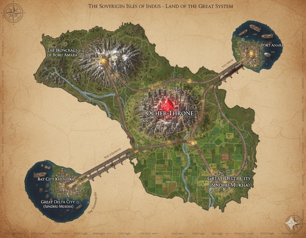
The national map of Indus illustrates a rugged, approximately 700-million-acre island nation defined by industrial precision and geographical variety. The landscape is dominated by a central megacity, from which four massive magi-steam arterial roads radiate outward like the spokes of a great gear. These roads are not merely infrastructure; they serve as the primary legal and geographic borders for the three internal states of the nation.
The Three States of Indus
- The Northern Iron-Reach: Located between the roads leading northwest and northeast, this state encompasses the high, snow-capped peaks of Khenifra’s Spine. It is the center of heavy mining and metallurgical research.
- The Western Plateau (The Arid Cradle): Defined by the space between the northwest and southwest roads, this region consists of rugged scrublands and deep canyons, home to the most ancient ruins of the predecessor civilization.
- The Southern Delta (The Green Machine): The vast area between the southern roads, characterized by broad, fertile river valleys and the nation’s massive agricultural output.
Major Cities of the Great System
Ocher-Throne (The Central Capital) The heart of the nation and the center of all logical order. The city is built in a concentric circular pattern around a massive, glowing Heart-Stone—a central crystalline spire that serves as the primary magical battery and stabilizer for the country. It is a vertical megacity of skyscrapers, steam-pipes, and elevated railways. All laws, guild charters, and major trade agreements are balanced and recorded here.
Port Anara (The Northern Gate) Situated on the northeast coast, Port Anara is a heavily fortified harbor built into granite cliffs. It handles the majority of the nation’s metal and mineral exports. The city is famous for its mechanical dry-docks where steam-powered ships and armored ironclads are maintained.
Bay City Khenifra (The Western Port) Located at the terminus of the southwestern road, this city serves as the primary link to the western island nations. It is a cosmopolitan melting pot where foreign merchants must exchange their currency for Indus metals. The city’s architecture features a mix of modern magi-steam towers and restored ancient docks.
Great Delta City (Sindhu-Mukha) Located on the southeast coast where the major rivers meet the ocean, this city is the center of the nation’s food and textile trade. It is built atop a series of artificial islands and dikes, showcasing the Praakrit mastery over water management. It serves as the primary port for airships and flat-bottomed river barges.
Points of Interest
The Ironcrags of Boru-Amara A massive mountain stronghold in the northwest where the air is thick with the smoke of forges. This is the industrial heartland where the largest steam-cores in Saṃsāra are manufactured. It is named after the legendary conflict between the builders Boru and Amara.
The Great River Sindh (Commerce Artery) Flowing from the central highlands to the southeastern coast, this river is a constant hive of activity. Thousands of steam-barges and magically propelled rafts transport raw materials from the interior to the coastal ports. The banks are lined with “Temple-Factories” dedicated to the maintenance of the river’s flow.
The Grid-Planned Ruins Scattered across the Western Plateau are the “ghost cities” of the ancients. These sites are active archaeological zones where Systematist scholars use their Mind’s Eye to uncover new Proto-Sindhian glyphs and technological blueprints.
The Coastal Sanctuaries Dotted along the jagged edges of the island, these are natural stone circles and caves where the Faith of the Great System honors the “Cycle of the Ochre Path.” These areas are guarded by elite Tier 3 soldiers to prevent the interference of chaotic “unbalanced” forces.
The map of Indus reveals a landscape where the natural geography has been meticulously “tamed” and optimized by the Praakrit and Mechta peoples. Beyond the primary arterials and megacities, a complex web of secondary infrastructure supports the nation’s 183-billion-acre industrial machine.
Secondary Communities and Rural Hubs
While the major roads are the “veins” of the country, the secondary communities are the “capillaries” that feed the system.
- Forge-Hamlets (The Northwest Spine): Clinging to the slopes of Khenifra’s Spine, these communities are built vertically. They are inhabited primarily by mining clans who live in dwellings carved directly into the basalt. Each hamlet is centered around a Geothermal Vent, which provides the heat necessary for local small-scale smelting.
- The Silt-Villages (Southern Delta): These are semi-mobile communities built on massive, flat-bottomed wooden platforms. As the river levels change with the seasons, these communities can be towed to different sectors of the fertile river valleys to manage various crops. They are the primary producers of the fibers used in Indus textiles.
- Waystations (Arid Plateau): Located at precise intervals along the major roads, these small, heavily fortified outposts provide water, steam-pressure recharging, and security for merchant caravans. They often grow into small trade towns known for their specialized “Road-Service” guilds.
Trade Routes and Logistics
Trade in Indus is a choreographed dance of mechanical power and logical timing.
- The Sky-Lanes: Above the primary roads, the “Airship Corridors” are strictly regulated. High-value goods—such as enchanted Glyphic Seals and refined Mana Crystals—are transported via zeppelins to avoid the slower ground traffic. These lanes follow the stable wind currents generated by the heat of the central megacity.
- The River Rail System: Along the banks of the Great River Sindh, mechanical tow-paths allow steam-tractors to pull massive lines of barges upstream against the current. This ensures that the flow of grain and raw timber to Ocher-Throne never ceases, regardless of the river’s natural temperament.
- The Under-Roads: Beneath the primary surface roads lie subterranean tunnels used for the transport of volatile alchemical substances and pressurized steam. These routes keep dangerous industrial components away from the general populace.
Natural Resource Zones
The nation is divided into “Functional Belts” based on the geological treasures found within the earth.
- The Crystalline Basin (Central Highland): Surrounding Ocher-Throne, the earth is rich in quartz and silicate deposits. These are harvested to create the “batteries” for magic storage and the lenses used in The Auditor’s Gaze helmets.
- The Copper-Canyons (West): The deep canyons of the western plateau reveal ancient veins of copper and tin. This area is the primary source of the bronze used for the nation’s countless gears, pipes, and the sacred Declaration of Function plates.
- The Rare-Earth Quarries (North): The Ironcrags contain pockets of rhodium and platinum. These are the most heavily guarded zones in the country, as these metals are essential for Tier 4 and Tier 5 gear.
Terrain and Climate Details
The terrain of Indus is a study in “Constructed Stability.”
- The Steam-Mist: Near major industrial hubs and Ocher-Throne, the air is often filled with a fine, warm mist—a byproduct of the thousands of steam engines. This has created a micro-climate where tropical plants thrive even at higher elevations.
- The Terraced Slopes: Almost every mountain in the Khenifra’s Spine has been terraced. These terraces serve a dual purpose: they prevent landslides (maintaining structural order) and provide space for high-altitude herb gardens used in alchemical skin secretions for the Anuran immigrants.
- The Glass-Sands: On the western coast, the magical runoff from ancient ruins has turned parts of the beaches into a shimmering, fused glass-sand. While beautiful, the terrain is treacherous and requires specialized “Traction-Boots” to navigate safely.