
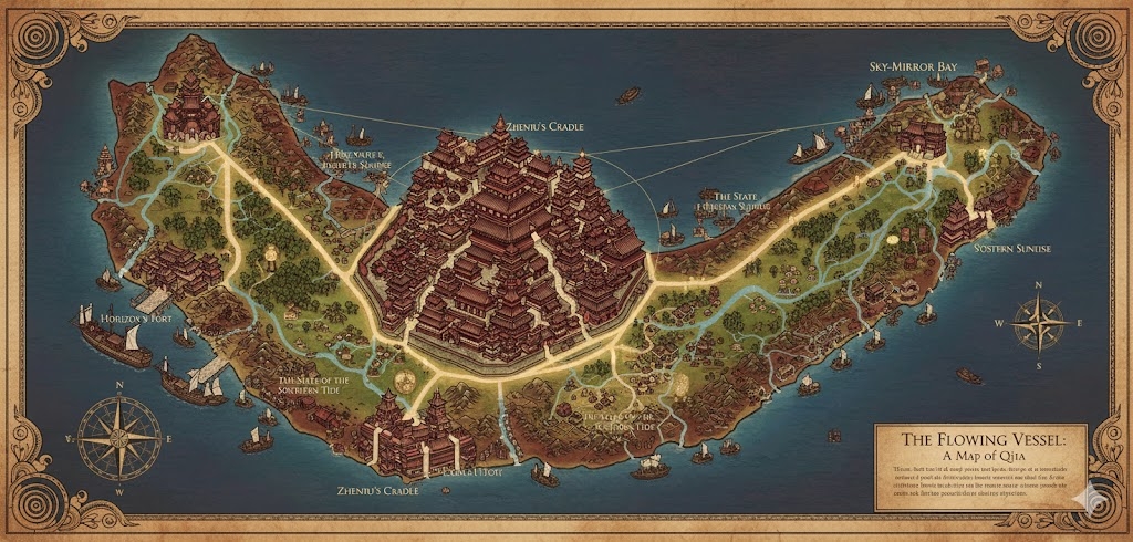
The national map of Qijia portrays an island defined by elegant geography and master-planned infrastructure, reflecting the Huayin commitment to balance and grace. The island’s 77.8 million inhabitants are distributed across a landscape of lush river valleys and steep coastal cliffs, all connected to the heart of the nation by the Imperial Silk-Roads.
The Three Administrative States
The three primary roads serve as the legal and geographic boundaries for the nation’s provinces:
- Huashu-Rim (North): The northern state between the North and East roads. It is the center of calligraphy, scholarship, and the most prestigious Rim Sanctuaries.
- Jinhuan-Basin (East/South): The region between the East and West roads, encompassing the fertile interior river valleys and the bulk of the nation’s agricultural terraces.
- Vessel-Coast (West): The state between the West and North roads, focused on maritime defense, shipbuilding, and the Great Seawalls.
Major Cities of Qijia
1. The Radiant Spire (Central Capital)
- Location: Built at the island’s highest central peak, the “Pivot of the Horizon.”
- Description: A masterpiece of red-and-ivory architecture, featuring tiered palaces that rise above the clouds. It is the home of the Huayin Queen and the primary Imperial Kiln.
- Role: The administrative and spiritual center. All major Yinlian archives are housed in the Spire’s libraries.
2. Port of the Turning Tide (Western Anchor)
- Location: The terminus of the Western Imperial Road on a jagged, cliffside coast.
- Description: A city of “water-steps,” where the harbor is tiered to manage the high-magic tides. The buildings are reinforced with stone to withstand ocean storms.
- Role: The headquarters of the Qijian Naval Fleet and the primary port for trade with neighboring island nations.
3. The Azure Delta (Eastern Anchor)
- Location: Situated where the twin interior rivers converge at the eastern coastline.
- Description: A sprawling “Venice-like” city built on a network of canals and bridges. It is famous for its floating markets and textile guilds.
- Role: The center of commerce and textile production. Much of the nation’s silk and refined pottery is exported from here.
4. North-Watch Terrace (Northern Anchor)
- Location: The end of the Northern Road, perched on the highest sea-cliffs of the island.
- Description: A city defined by its “Wind-Towers” and open terraces designed for the Way of the Vessel and Horizon vigils.
- Role: A strategic military watch-point and a site of pilgrimage for those seeking Zhenmu’s blessing for long-distance voyages.
Points of Interest and Commerce
- The Twin Currents (Major Rivers): These two rivers flow from the central mountains to the Azure Delta. They are crowded with Ceramic-Barges—sleek, low-profile vessels carrying raw clay and finished porcelain. The commerce here is silent and rhythmic, often managed by Huayin sailors using subsonic rumbles for coordination.
- The Imperial Silk-Roads: These roads are meticulously maintained, paved with crushed white stone that reflects the moonlight. They feature Crane-Stations every few miles—rest stops with tall towers where messages are relayed via light signals.
- The Glass-Terraces: Located in the central highlands, these are massive stepped farmlands where magical rice is grown. From the sky, they look like mirrors reflecting the “Horizon-Light.”
- The Mother’s Kiln: A massive, dormant volcanic vent near the capital that has been converted into a communal kiln. It is where the largest ceremonial Mother’s Vessels are fired for the entire nation.
- The Whispering Gorges: Deep canyons where the wind creates natural harmonic tones. Huayin linguists visit these gorges to study new Yinlian tonal sequences.
This map illustrates a nation that functions as a single, coordinated Vessel, where every road and river serves to return resources and information to the “Source” at the center.
The map of Qijia functions as a meticulously balanced ecosystem, where the 77,840,000 inhabitants are distributed in a way that maximizes both artistic production and spiritual alignment with the Way of the Vessel and Horizon. The 300-million-acre island is partitioned into zones that emphasize the Huayin values of “Climbing the Sky” and “Holding the Past.”
Secondary Communities: The Specialized Outposts
While the primary “Anchors” handle international trade, the interior is supported by specialized Tier 2 and Tier 3 communities:
- The Kiln-Villages (Terraced Highlands): Scattered across the northern slopes of the central mountains. These are semi-subterranean communities built around geothermal vents. Every family here is part of the Potters’ Guild, specializing in the “Red and Ivory” ceramics used in Rim Sanctuaries.
- Ink-Hollows (River Valleys): Located in the humid, low-lying forests near the Azure Delta. These communities cultivate “Resonance Plants,” which are harvested to create the mineral-based inks used for Huashu calligraphy on the city story-walls.
- The Weaver’s Roosts: Communities built into the sheer cliffs of the southern coast. Here, Huayin use their natural climbing ability and digitigrade precision to operate massive vertical looms, producing the enchanted silks and embroidered sashes worn by the nobility.
- Beacon-Points: Small, high-altitude military outposts located along the mountain rims. They are populated by elite Huayin scouts who monitor the horizon for incoming threats or disappearing island events.
Trade Routes: The Flow of the Vessel
Commerce in Qijia is governed by the “Dual Currents” philosophy—everything that flows out must eventually be returned to the center.
- The Silk-Roads (Terrestrial): These white-stone highways are the primary arteries for luxury goods. Caravans of agile Huayin merchants move swiftly along these roads, carrying finished porcelain and delicate magical gear. The roads are designed with “Balance-Platforms” every few miles to allow for the silent Horizon Vigils at dawn and dusk.
- The Canal Network (Riverine): The interior river valleys are threaded with artificial canals. Sleek, low-profile barges decorated with spiral motifs transport bulk raw clay, timber, and grain. These barges are often propelled by “Water-Shaping” rituals performed by Tier 3 navigators using Yinlian chants.
- The Sky-Rungs (Vertical): Unique to Qijia, these are systems of ropes, pulleys, and “climbing-stairs” that connect the valley floors to the mountain cities. They are optimized for the Huayin’s retractable claws and balance, serving as high-speed transit for the ruling dynasty.
Natural Resource Zones: The Clay and the Light
The terrain is strictly audited by the monarchy to ensure no resource is wasted:
- The Kaolin Pits (Northwest): The source of the nation’s world-famous white clay. The mining here is conducted with ritual precision; every excavation is treated as “shaping the earth,” and depleted pits are converted into beautiful water gardens or kiva-like meditation pools.
- The Solar-Sills (Southern Mesas): Arid, flat-topped mesas that receive the most intense “Horizon-Light.” These are the primary zones for drying treated fabrics and harvesting the solar mana used to power the beacon-towers.
- The Mulberry Canopies: Massive ancient forests in the interior where the silk-worms are bred. These forests are treated as sacred sanctuaries, and entry is restricted to licensed members of the Weaver’s Guild.
Terrain and Geological Features
- The Stepped Watershed: The island’s central mountains are designed with massive stone basins. During the monsoon seasons, rainfall is channeled from the peaks down through a series of “filtering terraces,” ensuring every coastal city has access to pure mountain water.
- The Harmonic Gorges: In the eastern highlands, the wind-carved limestone creates natural flutes. The Huayin use these gorges as natural acoustic laboratories to refine the tonal overtones of the Jinhuan language.
- The Seawall Rim: The western coastline is reinforced with massive, hand-carved stone blocks inscribed with Yinlian protective charms. This prevents erosion and protects the Tiered Harbors from the unpredictable waves of the endless ocean.
The geography of Qijia is not merely a place to live; it is a Vessel in itself, meticulously maintained to ensure the nation remains as stable as a crane standing on a pot’s rim.