
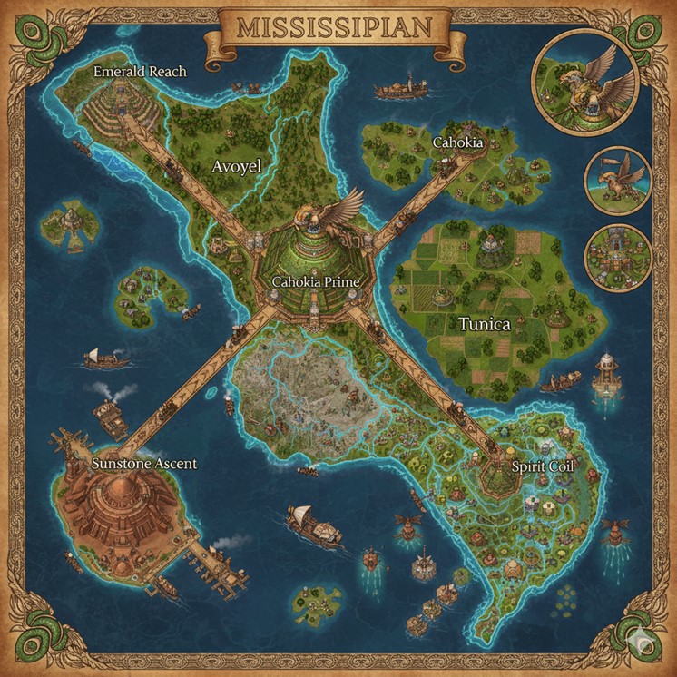
The national map of Mississippian portrays a large, central island mass surrounded by a constellation of smaller islands, all set within an endless ocean. The geography is diverse, featuring lush green plains, dense forests, and intricate river delta systems that carve through the southern portion of the landmass. The civilization is clearly advanced and well-established, with large, architecturally complex cities and a robust infrastructure of roads and trade routes. The aesthetic is a fusion of earthen, mound-based structures and steampunk-inspired technology, with steam barges navigating the waters and airships floating in the skies. A decorative border with coiled serpent motifs frames the map, reinforcing the cultural themes of the nation. Inset illustrations on the right side of the map provide closer views of a griffon rider, a national banner held by a griffon, and an aerial view of a smaller mound settlement.
Major Cities
Cahokia Prime Located at the very heart of the island nation, Cahokia Prime is the central capital megacity and the hub from which all major infrastructure radiates. It is depicted as a colossal, multi-tiered mound structure, resembling a massive ziggurat that dominates the surrounding landscape. A great winged effigy, likely representing a griffon or a symbol of the House of Cahokia, sits atop the central pyramid, signifying its status as the seat of government. The city is a marvel of engineering, with structures built into and upon the great earthenwork. It serves as the nexus for four major, elevated roadways that connect it to the key coastal cities, physically and politically cementing its authority over the entire nation. The area immediately surrounding Cahokia Prime appears to be a mix of smaller mounds, green spaces, and dense urban development, indicating a massive population center.
Emerald Reach Situated on the northwestern coast, Emerald Reach is a major coastal city that appears to be a center for trade and agriculture. The city is built upon a large coastal mound, similar in style to Cahokia Prime but on a smaller scale. Its strategic location at the mouth of a river and its direct road connection to the capital make it a vital port. The lands surrounding Emerald Reach are lush and green, suggesting fertile ground for farming. Several steam-powered barges are visible in the waters near the city, actively engaged in commerce, likely transporting goods to and from the capital and other islands. The architecture features prominent earthen pyramids adorned with green, possibly from cultivated flora or the use of specific minerals in their construction, giving the city its name.
Sunstone Ascent On the southwestern peninsula lies Sunstone Ascent, a major city distinguished by its unique, reddish-brown architecture. Unlike the other cities which are built upon green, earthen mounds, Sunstone Ascent’s structures appear to be made of stone or clay, resembling a large, domed ziggurat or temple complex. This city functions as a significant coastal hub, with numerous docks and steam barges visible in its harbor, indicating a bustling center of maritime trade. Its position makes it a gateway to the southern river deltas and the open sea. The name “Sunstone Ascent” suggests a cultural or religious significance related to the sun, or perhaps it is known for a particular resource or craft involving sun-colored stones.
Spirit Coil Spirit Coil is a sprawling city complex nestled in the southeastern region, deeply integrated with the intricate river delta system that defines this part of the island. It is not a single, monolithic mound but a vast collection of smaller mounds, platforms, and structures connected by bridges and waterways. This city appears to be the most populous and perhaps the most ancient, with a dense, organic layout that follows the natural contours of the land and water. Steam barges and smaller vessels navigate the channels that run through the city itself, suggesting that commerce and daily life are intrinsically tied to the rivers. The name “Spirit Coil” evokes the coiled serpent imagery of the Path of the Eternal Mound, and the city’s winding, interconnected nature reflects this theme perfectly. Airships are also visible above the city, indicating it is a hub for multiple forms of travel.
States and Regions
The four great roads extending from Cahokia Prime act as the boundaries for the primary states of the nation.
- Avoyel: The northwestern state, bounded by the roads leading to Emerald Reach and Sunstone Ascent. It is characterized by green, rolling hills, forests, and smaller mound settlements scattered throughout the landscape.
- Tunica: The northeastern state, defined by the roads to Emerald Reach and Spirit Coil. This region is depicted as a major agricultural heartland, with vast, neatly organized fields and farmlands. It appears to be the primary food producer for the nation, supplying the dense urban centers.
- Cahokia: The central state or capital region directly surrounding Cahokia Prime.
- The southern region containing the river deltas and the city of Spirit Coil appears to form another distinct state, defined by its unique geography and dense population centers.
Points of Interest
- The Great Roads: Four massive, elevated causeways or bridges stretch from Cahokia Prime to the coastal cities. They are monumental feats of engineering, allowing for the rapid transit of goods and people across the nation, high above the natural terrain.
- River Commerce: The map is teeming with activity on the water. Large steam-powered barges, belching clean, white steam, are shown navigating the open seas between islands and along the major rivers. This highlights the critical role of riverine and maritime trade in the nation’s economy.
- Aerial Travel: Floating in the skies are numerous airships and what appear to be griffon riders. These vessels and creatures signify an advanced understanding of levitation magic and steam power, providing another vital mode of transport for trade, travel, and defense, especially for reaching the smaller, more remote islands.
- Surrounding Islands: The main island is encircled by dozens of smaller islands. Some host minor settlements and mounds, while others appear to be resource outposts or agricultural colonies, all interconnected by the network of steam barges and airships.
Detailed Terrain and Topography
The island nation’s landscape is a study in contrasts, providing the foundation for its regional specializations.
- The Southern River Delta: The most striking feature is the vast, labyrinthine river delta that dominates the southeastern portion of the island. This is a humid, low-lying region of interconnected waterways, marshes, small islands, and fertile floodplains. The entire area is the domain of the city of Spirit Coil, whose infrastructure is woven directly into the delta itself. This terrain is exceptionally rich in life but also inherently unstable, prone to magical ebbs and seasonal floods, which culturally reinforces the necessity of building upon stable, elevated mounds.
- The Northeastern Plains: The state of Tunica is defined by its expansive and fertile plains. These are not perfectly flat but consist of gently rolling hills and wide-open grasslands, making the region the undisputed agricultural heartland of the nation. The soil here is likely rich with mana-infused sediment deposited over millennia, ideal for large-scale farming.
- The Northwestern Woodlands: The state of Avoyel is characterized by a more rugged and elevated terrain of wooded hills and dense forests. This region features a higher concentration of old-growth trees and a more varied topography than the eastern plains, suggesting it is a primary source of lumber and other forest resources.
- The Southwestern Peninsula: The landmass where Sunstone Ascent is located appears to be a geologically distinct peninsula. Its rockier, more arid appearance suggests it is a source of stone, clay, and perhaps valuable minerals. This region is less suited for large-scale agriculture, forcing its economy to focus on quarrying, mining, and maritime trade.
Natural Resource Zones
Each region’s unique terrain gives rise to specialized zones of resource extraction that fuel the nation’s economy.
- Agriculture (Tunica): The plains of Tunica are the nation’s breadbasket. Vast fields, likely tended with the aid of steam-powered constructs and elemental magic, produce the staple grains and crops necessary to feed the massive populations of the major cities.
- Lumber (Avoyel): The forests of the northwest are the primary source of timber. This wood is essential for constructing buildings, the hulls of steam barges, the frameworks of airships, and for crafting goods. Given the scale of Mississippian’s infrastructure, these are likely managed forests, carefully cultivated to ensure a sustainable supply.
- Stone & Minerals (Sunstone Ascent): The southwestern peninsula is the heart of the nation’s quarrying and mining operations. The distinctive reddish stone used in its own architecture is likely exported for use in high-status buildings across the island. Clay pits would supply the material for the inscribed tablets mentioned in the nation’s lore, while mineral veins could provide the raw materials for metal components used in steam technology and conduits.
- Riverine & Marine Resources (Spirit Coil Delta): The southern delta is an abundant source of fish, crustaceans, and other aquatic life. More importantly, it is the primary source of the shells that are culturally and magically significant, used for inlay in mounds, as decorative motifs, and as components in crafting magical conduits. The unique flora and fauna of the marshes would also be a source of alchemical reagents.
Secondary Communities
Beyond the great cities, the map indicates a multitude of smaller settlements, each serving a vital function.
- Delta Villages: Scattered throughout the southern delta are dozens of smaller mound-villages. These communities are built on the few stable points of land and are entirely oriented around the water. Their inhabitants would be fishers, shell-harvesters, and expert river navigators who guide the larger steam barges through the delta’s treacherous channels.
- Farming Hamlets: The plains of Tunica are dotted with small farming communities. These hamlets would consist of a few family mounds clustered around a central, fortified granary or a shrine to Itakwa. They are connected by smaller dirt roads and are responsible for the day-to-day cultivation of the fields.
- Logging Camps: Deep within the forests of Avoyel are secondary communities dedicated to harvesting timber. These would be rugged settlements, often temporary or seasonal, focused on felling trees and transporting the logs downriver or via steam-cart to the port at Emerald Reach.
- Islet Outposts: The smaller islands surrounding the main landmass host specialized outposts. Some serve as military garrisons to watch over the sea lanes, others are isolated monasteries for the Path of the Eternal Mound, and many are dedicated to specific tasks like harvesting rare aquatic plants or serving as waystations for long-haul airship voyages.
Trade Routes and Commerce Flow
The movement of goods and people follows a clear and efficient logic, utilizing land, water, and air.
- The Great Roads: These elevated causeways are the arteries of the nation, designed for the rapid transport of processed goods, military legions, and official envoys. Raw materials are typically processed in the major coastal cities before being shipped inland to Cahokia Prime via these roads. For example, raw timber from Avoyel is turned into lumber at Emerald Reach before being sent to the capital.
- The River Network: The southern delta’s waterways serve as the veins of local commerce. A constant flow of small skiffs and medium-sized barges moves raw materials like fish and shells from the delta villages to the markets of Spirit Coil. In return, finished goods, tools, and grain from the rest of the nation are distributed back down through the delta.
- The Coastal Sea Lanes: A continuous loop of heavy steam barges connects the four major coastal cities. Sunstone Ascent ships stone and minerals to the other ports; Spirit Coil exports exotic foods and alchemical components; Emerald Reach provides lumber and goods from the north. This maritime traffic is the backbone of inter-state commerce.
- The Sky-Lanes: The most direct and fastest routes are in the air. Airships and griffon riders carry high-value cargo, important passengers, and official correspondence. These routes connect the five major cities directly, flying over any terrain, making them essential for urgent communication and the transport of luxury items or powerful magical artifacts.