
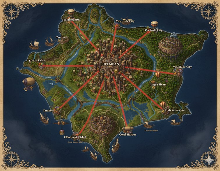
This map illustrates the island nation of Lupemban, a verdant, roughly circular landmass defined by its intricate network of rivers and dense rainforests. The coastline is varied, featuring deep inlets, wide river deltas, and sheltered bays. A massive, centrally located capital city, also named Lupemban, serves as the hub for a series of prominent red roads that radiate outwards to the coast, dividing the nation into distinct states. These roads connect the capital to major coastal cities, facilitating trade and governance. The island is dominated by extensive river systems that are clearly arteries of commerce, bustling with ships. The terrain is a mix of lush, low-lying jungles, elevated plateaus, and mountainous regions, particularly in the south. Evidence of a technologically advanced society, blending magic and steam power, is visible in the architecture of the cities and the presence of airships alongside traditional sailing vessels.
Major Cities
- Lupemban (The Capital Megacity): Located near the geographic center of the island, Lupemban is a sprawling megacity of immense scale. It is characterized by its towering, tree-like skyscrapers that pierce the jungle canopy, humming with the activity of millions of souls. As the seat of the matrilineal monarchy and the Royal Line of Eternal Drums, the city is the political, economic, and cultural heart of the nation. Its architecture is a fusion of organic forms and industrial function, with structures pulsating with drum motifs and steam-driven mechanisms. Major roads, constructed from distinctive red clay, originate here, connecting the capital to every major coastal hub and serving as the demarcating lines for the nation’s states. It is a center for high-tier gear forging, political intrigue, and the grandest ceremonies of the Tamborism faith.
- Tambori: Situated on the western coast at the mouth of a major river, Tambori is a vital riverine hub and port city. It thrives on trade, with its docks bustling with ships arriving from across the endless ocean and river vessels that navigate the inland waterways. As a major center for the nation’s councils, delegates from Tambori play a significant role in the governance of Lupemban. Its proximity to the Tanaris Delta makes it a key location for agricultural trade and the export of resources harvested from the dense western rainforests.
- Tamboriard: North of Tambori, along the northwestern coast, Tamboriard is another significant port city. It appears to be a major naval and trade outpost, facilitating commerce with northern island nations. Its strategic location at the confluence of several river channels makes it a critical node in Lupemban’s transportation network, controlling access to the northern interior. The waters around it are busy with sailing ships, indicating its importance in maritime trade.
- Vineshade City: This name appears three times along the northeastern and northern coasts, suggesting it may be a single, vast urban area or a collection of closely linked city-states under a common name. Vineshade City is nestled within the dense jungle, with one major settlement situated atop a large, flat-topped mountain or plateau. It is likely a center for the harvesting and processing of the region’s abundant magical flora, such as enchanted vines, and a hub for artisans and alchemists. Its elevated district suggests a focus on defense and possibly airship travel.
- Plateau Respite: Located on the southeastern coast, this city is built upon a high plateau overlooking the sea. Its position suggests it is a defensive stronghold and a center for industry that may harness geothermal energy from the volcanic foothills mentioned in the lore. It serves as a key port for the southeastern region, with access to both the ocean and the interior via the river system. Hot air balloons are visible nearby, indicating it is a hub for this form of travel.
- Coral Harbor: A major port city on the southern coast, Coral Harbor is sheltered within a large bay. It likely specializes in maritime trade, fishing, and perhaps interactions with underwater civilizations. Its name suggests the presence of significant coral reefs, which could be a source of unique alchemical ingredients or trade goods. The city connects the southern state to the capital via a major red road.
- Cloudpeak Citadel: Dominating the southwestern peninsula, Cloudpeak Citadel is a fortified city built into and atop a mountain range. This formidable settlement serves as a military stronghold, guarding the southwestern approach to the nation. Its high altitude and defensible position make it an ideal location for griffon aeries and airship docks, controlling the skies in this region. It is a bastion of the Pembalu’s martial heritage and a center for the training of elite forces.
Points of Interest
- Tanaris Delta: Located in the west, near the city of Tambori, this is a vast and fertile river delta. Formed by the convergence of several rivers, its rich soil supports bountiful agriculture, likely producing the mana-enriched grains that sustain the nation. The delta is a critical economic zone and a hub of riverine commerce.
- Jungle Heart: A region deep within the eastern rainforest, the Jungle Heart is likely an area of immense natural mana and biodiversity. It may be home to ancient ruins, sacred groves central to the Tamborism faith, and unique magical beasts or sentient plant collectives, such as the vine collectives mentioned in the lore. It represents the untamed, mystical core of Lupemban’s wilderness.
- Coastal Shoals: The waters off the southeastern coast are marked as Coastal Shoals. This area of shallow water and reefs could be both a navigational hazard for large ships and a rich resource for fishing and the harvesting of marine resources. It may also be the site of underwater enclaves or shipwrecks holding forgotten treasures.
Secondary Communities and Settlements
Beyond the major named cities, the map of Lupemban is dotted with numerous smaller, unnamed settlements. These communities are strategically located along the extensive river systems and coastlines, highlighting their dependence on water for transport and sustenance.
- Riverine Villages: Clusters of smaller settlements are visible all along the banks of the major rivers. These communities likely function as agricultural hubs, cultivating the fertile floodplains and river deltas. They would be responsible for producing the enchanted grains and other foodstuffs that feed the larger cities. They also serve as local waypoints for river trade, collecting goods from the immediate vicinity to be loaded onto larger barges headed for hubs like Tambori and the capital.
- Coastal Hamlets: Along the coastline, particularly in sheltered coves and bays between the major ports, are smaller fishing hamlets. These settlements would focus on harvesting marine resources from areas like the Coastal Shoals. They supply the nation with fish and other sea-based alchemical components, trading their surplus at nearby ports like Coral Harbor and Tamboriard.
- Highland Outposts: In the mountainous southern regions, especially around the Cloudpeak Citadel and Plateau Respite, there are smaller, more isolated communities. These likely function as mining outposts, extracting red clay, metals, and precious gems from the mountains. They may also serve as watchposts or monasteries, taking advantage of their defensible and secluded locations.
Trade Routes and Commerce
Lupemban’s economy is visibly driven by a complex network of trade routes that crisscross the island by land, river, and sea.
- River Commerce: The rivers are the lifeblood of domestic trade. The map shows a high volume of barge and ship traffic along every major waterway. Raw materials such as timber, mana-infused woods, and agricultural goods from the interior are transported downriver to the coastal cities. In return, manufactured products like forged gear, steam-powered tools, and alchemical dyes from the industrial centers are shipped inland to the smaller communities. The confluence of rivers directly south of the capital appears to be a particularly busy junction for this internal trade.
- Maritime Shipping: The waters surrounding Lupemban are filled with large sailing vessels and what appear to be steam-powered ships, indicating robust international trade. Ports like Tamboriard, Coral Harbor, and Vineshade City are critical for exporting Lupemban’s unique goods—such as enchanted vines, red clay gear, and alchemical resins—to the other 72 island nations. They also import resources not found on the island and serve as entry points for isekai souls arriving by sea.
- Airship and Balloon Routes: The presence of zeppelins and hot air balloons signifies a third layer of trade and travel. These air routes are likely used for high-value, low-weight goods and for rapid transport of officials, messengers, and wealthy individuals. An airship is notably present near the Tanaris Delta, suggesting a route between Tambori and the capital. Another is seen near Plateau Respite, indicating a connection along the southeastern coast. These routes would be crucial for bypassing difficult terrain and maintaining swift communication across the nation.
Natural Resource Zones and Terrain Details
The varied terrain of Lupemban provides a wealth of natural resources that fuel its industries and culture.
- Rainforests and Jungles: The vast green expanses covering most of the island’s interior are dense, humid rainforests. The Jungle Heart region is likely the most ancient and magically potent of these. These forests are the primary source of enchanted vines, rare woods for crafting staffs and scepters, and a plethora of magical flora and fauna used in alchemy and for sustenance. The canopy is thick, creating a dimly lit environment on the forest floor, ideal for the Pembalu and their enhanced low-light vision.
- River Valleys and Deltas: The low-lying areas surrounding the rivers, especially the Tanaris Delta in the west, are characterized by incredibly fertile alluvial soil. This is the agricultural heartland of the nation, dedicated to large-scale farming. These areas are prone to seasonal flooding, a natural force that the people of Lupemban likely manage and harness using the water-shaping magic of Tamborism.
- Highlands and Plateaus: The southern portion of the island is more mountainous and elevated. The region around Cloudpeak Citadel consists of rugged peaks, while the area near Plateau Respite is defined by high, flat-topped mesas. These highlands are the source of Lupemban’s mineral wealth, providing the red clay used in construction and gear-forging, as well as metals, crystals, and gems. The terrain is also naturally defensible, making it ideal for military strongholds.
- Coastal and Marine Zones: The coastline is a mix of sandy beaches, rocky cliffs, and mangrove-choked estuaries where the rivers meet the sea. The Coastal Shoals and the bay sheltering Coral Harbor are rich marine ecosystems. These zones provide not only fish but also pearls, magical corals, and other valuable resources for crafting and alchemy.