
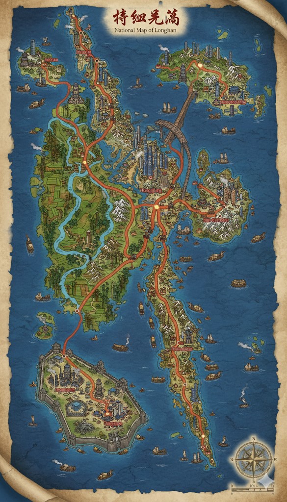
This photorealistic national map portrays the island nation of Longshan as a large, elongated landmass, rich in geographical diversity and steeped in a distinct architectural and cultural style. The nation is comprised of a main island and several smaller, yet significant, islands to the north and south. The overall impression is one of a vibrant, interconnected society where nature and a technologically advanced, magic-fueled civilization coexist. The map is rendered in an antique style, with a parchment-like background and a compass rose indicating direction, lending it the feel of a historical document from within the world of Saṃsāra.
The topography of Longshan is varied and dramatic. A spine of rugged, mist-shrouded mountains runs through the center of the main island, their peaks giving rise to numerous rivers that flow outwards to the sea. These rivers have carved fertile valleys and plains, which are depicted as verdant and extensively cultivated with terraced farms. The coastlines are irregular, featuring numerous bays, inlets, and natural harbors that have fostered the growth of coastal cities. The waters surrounding Longshan are dotted with smaller, uncharted islands and teeming with maritime traffic, from small fishing vessels to large, multi-sailed trade ships, indicating a thriving oceanic economy.
A prominent feature of the map is the extensive and well-developed road network, highlighted in a distinct red color that makes it stand out against the landscape. These roads are not mere paths but significant feats of engineering, cutting through mountains and bridging valleys. They all emanate from a central point, the capital city, and branch out to connect the disparate regions of the nation, acting as the arteries of trade, communication, and military movement. The major roads also serve as the political boundaries for the nation’s internal states.
The architecture depicted across the nation is a consistent and unique blend of traditional East Asian design and steampunk-inspired technology. Cities are characterized by towering pagoda-skyscrapers, buildings that reach incredible heights while retaining the classic curved roofs and intricate details of ancient temples. This suggests a society that has achieved vertical growth and high population density without abandoning its cultural aesthetic. The presence of bridges, aqueducts, and what appear to be steam-powered vessels further reinforces the theme of a magic-driven industrial age.
Major Cities and States
The roads radiating from the capital divide the main island into three distinct states. Each state is defined by its geography and the major coastal city that serves as its regional hub.
- Yongjing (The Capital Megacity): Located near the geographical center of the main island, Yongjing is a sprawling metropolis that serves as the political, economic, and cultural heart of Longshan. The city is a breathtaking forest of pagoda-skyscrapers that pierce the clouds, their design intricate and majestic. It is situated at the confluence of several major rivers and is the nexus of the national road network, solidifying its importance as the center of all commerce and travel. The sheer scale and density of Yongjing suggest a population in the millions, a true megacity where the ancient and the magically industrial merge.
- The State of Heiyan: Bounded by the northern road and the western coast, the state of Heiyan is a region of significant industrial and maritime importance.
- Heiyan (City): This major coastal city is situated in the northeastern part of Longshan. Its large, well-protected harbor is filled with ships of all sizes, indicating its role as a primary port for international trade. The city itself is a dense urban center, with numerous pagoda-skyscrapers and what appear to be large warehouses and industrial complexes, likely powered by the steam technologies mentioned in the lore of Saṃsāra. A massive, arched bridge connects Heiyan to the northern territories, showcasing the nation’s advanced engineering capabilities.
- The State of Lanyang: This state occupies the southern portion of the main island, defined by the southeastern road. It appears to be a region of significant agricultural and spiritual importance.
- Lanyang (City): Located on the southeastern coast, Lanyang is another major port city. While still a bustling urban center, it seems to have a more spiritual or monastic character than Heiyan. The city is surrounded by terraced farms that climb the hillsides, suggesting it is a center for food production. The architecture, while still grand, incorporates more temples and open spaces than the industrial intensity of Heiyan.
- The State of Jiangnan: The southwestern part of the nation is defined by the southwestern road. This region appears to be a mix of fertile plains and dense forests.
- Hongjiang (City): Situated on the southwestern coast, at the mouth of a major river, Hongjiang is a significant port city. It appears to be a center for both trade and resource gathering from the surrounding region.
- Qingshui (City): Located on the southern island, Qingshui is a fortified city, enclosed by massive walls. Its strategic location suggests it may be a military stronghold or a vital trade outpost guarding the southern sea lanes.
Points of Interest
Beyond the major cities, the map is rich with other points of interest that add depth and character to the nation of Longshan.
- The Great North Bridge: This immense arched bridge is a marvel of engineering, spanning a wide strait to connect the northernmost island to the main continent. Its scale suggests it is a major artery for trade and travel, capable of accommodating heavy traffic.
- River Commerce: The major rivers are depicted not just as geographical features but as vital commercial highways. They are filled with barges and smaller vessels, transporting goods between the interior and the coastal cities. Small settlements and trading posts are visible along their banks, highlighting their importance to the nation’s economy.
- Northern Territories: The smaller islands to the north, such as Beihai and Dongying, appear to be more sparsely populated but are still connected to the main road network. They may serve as fishing communities, military outposts, or locations for specialized resource extraction.
- The Southern Fortress Island: The southernmost island is dominated by the walled city of Qingshui. The island itself is rugged and mountainous, making the fortified city its most prominent feature. This island likely plays a crucial role in the defense of Longshan’s southern flank.
- Terraced Farmlands: Throughout the nation, but particularly in the valleys and coastal plains, the landscape is dominated by extensive terraced farming. This indicates a society that has mastered agriculture and is capable of sustaining a large population.
- Mountain Passes and Monasteries: The central mountain range is not an impassable barrier. The roads cut through it via high passes, and in the more remote mountain areas, small, isolated structures can be seen, possibly representing monasteries or watchtowers.
In its entirety, the map of Longshan presents a nation that is both ancient and advanced, a land of stunning natural beauty and incredible man-made (or avatar-made) wonders. It is a realm of political intrigue, bustling trade, and a deep connection to the magical energies that flow through the world of Saṃsāra.
Secondary Communities and Settlements
Beyond the sprawling megacities, the map of Longshan is dotted with numerous smaller communities, each playing a vital role in the nation’s ecosystem.
- Agricultural Hamlets: Nestled within the vast terraced farmlands, especially in the states of Jiangnan and Lanyang, are countless small hamlets and villages. These communities are not individually named on the map but are represented by clusters of smaller pagoda-style buildings. They serve as the homes for the farmers and laborers who cultivate the enchanted grains and teas for which Longshan is known. Their proximity to the major rivers suggests they use the waterways to transport their harvests to the larger cities.
- Mountain and Mining Outposts: High in the central mountain spine, several isolated settlements are visible. These are likely mining outposts, established to extract the rich veins of jade, coal (for steam power), and precious metals hinted at in the lore. Their connection to the main road network is often via smaller, winding paths, indicating the challenging nature of their work. A notable example is the town of Baiyun, situated near the northern peak, which appears to be a significant mining and lumber community.
- Monastic Retreats: Tucked away in the most remote and serene mountain locations are secluded structures that appear to be monasteries or temples. These communities are dedicated to the practices of Heitaoism or scholarly pursuits, intentionally set apart from the bustle of the cities. They likely serve as places of pilgrimage and repositories of ancient knowledge.
- Fishing Villages: The extensive coastline is peppered with small fishing villages located in sheltered coves and inlets. These communities are crucial for supplying the nation with seafood and are centers for boat building and repair. They are connected by sea to the larger ports rather than by the main road network. The northern island of Beihai, in particular, seems to be a hub for these fishing operations.
Trade Routes and Commerce
Longshan’s economy is driven by a complex network of internal and external trade routes.
- The Imperial Road Network: The primary red roads are the arteries of internal commerce. Heavily-laden caravans, likely pulled by beasts or powered by steam, would constantly travel these routes, transporting raw materials like ore and lumber from the mountain outposts to the industrial cities, and distributing finished goods like pottery, textiles, and crafted gear back to the rural communities.
- Riverine Commerce: The nation’s extensive river system forms a secondary, but equally important, trade network. The map shows numerous barges and smaller vessels navigating these waterways. They transport agricultural goods from the fertile plains to the coastal ports and carry manufactured items inland. This river traffic is vital for the economic integration of the nation’s interior.
- Maritime Trade Lanes: The seas around Longshan are bustling with activity. Major sea lanes connect the primary ports of Heiyan, Lanyang, Hongjiang, and the fortress-city of Qingshui. These ports are hubs for international trade, with large, ocean-going ships arriving from and departing to other island nations across Saṃsāra. The sheer volume of ships suggests that Longshan is a major exporter of goods such as its famous black pottery, enchanted teas, silks, and magical gear. The routes also facilitate the import of goods and the arrival of isekai souls from across the multiverse. The southern routes appear particularly heavily guarded, likely due to the proximity of uncharted waters and potential monster threats.
Natural Resource Zones and Terrain Details
The varied terrain of Longshan provides a wealth of natural resources that fuel its society.
- Agriculture (The Great Valleys): The most prominent resource zone is the vast agricultural land in the river valleys and coastal plains. The extensive terracing seen on the map is a testament to the nation’s mastery of agriculture, allowing them to maximize food production in the mountainous terrain. These areas are the breadbasket of the nation, producing not only staple foods but also valuable cash crops like tea.
- Mining (The Dragon’s Spine Mountains): The central mountain range is the primary source of mineral wealth. The rugged peaks and deep caverns are rich in jade, which is culturally and magically significant, as well as coal to power the steam-based industry, and various ores for metalworking. The terrain is treacherous, marked by steep cliffs, deep gorges, and frequent seismic activity.
- Lumber (The Northern Forests): The northern parts of the main island and the smaller northern islands are depicted with dense forests. These woodlands provide the lumber necessary for construction, shipbuilding, and crafting. The forests are likely ancient and mystically potent, possibly home to unique magical flora and fauna.
- Fisheries (The Coastal Shallows): The waters surrounding the archipelago are a rich source of fish and other seafood. The numerous fishing villages attest to the importance of this resource for both sustenance and trade. The southern coast, with its many small islands and reefs, is likely a particularly productive fishing ground.
- Terrain Nuances: The coastline of Longshan varies significantly. The eastern coast, home to Heiyan and Lanyang, features large, open bays and well-protected harbors conducive to large-scale trade. In contrast, the western coast appears more rugged and wild, with fewer major settlements. The central mountains are not a single monolithic range but a complex system of peaks and valleys, creating many isolated regions and fostering a diversity of local cultures and ecosystems. The southern fortress island is particularly stark and rocky, a natural bastion against threats from the open ocean. This combination of fertile plains, resource-rich mountains, and accessible coastlines makes Longshan a powerful and self-sufficient nation.