
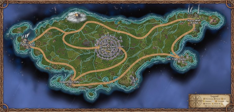
The national map of Kurgan depicts a large, verdant island of irregular shape, surrounded by a deep blue ocean with swirling currents. The coastline is varied, featuring sheltered bays, sheer cliffs, and small offshore islets. A prominent, well-developed road network, appearing as wide, paved thoroughfares, forms the primary infrastructure, connecting a central capital to major coastal cities. These roads also serve as the clear boundaries for the nation’s provinces. Numerous rivers and their tributaries flow from the island’s interior highlands towards the sea, carving paths through the rolling grasslands and pockets of forest. The landscape is dotted with the culture’s signature spiral barrows, visible as terraced, circular mounds.
Major Cities
Helix Crown City Located near the geographic center of the island, Helix Crown City is a sprawling megacity and the nation’s capital. The city is built in a series of concentric, circular tiers, mirroring the spiral motif central to Kurgan culture and faith. At its heart lies what appears to be the Grand Wind-Helix Temple and the monarch’s seat of power. The road network radiates from this central hub like the spokes of a wheel, underscoring its importance as the political, cultural, and logistical core of the nation. Its dense architecture suggests a massive population, with countless structures packed tightly within its spiraling walls.
Aerie’s Rest Situated on the northwestern coast, Aerie’s Rest is a major industrial city. Its skyline is dominated by towering structures emitting plumes of steam, indicating the presence of the wind-and-steam-driven foundries and factories mentioned in Kurgan lore. The city is nestled in a region of high cliffs and is strategically positioned near the island’s large, smoking volcano. Its name suggests it is a primary hub for aerial travel, likely housing the cliff-nest docks for glider couriers and serving as a major aerodrome for the nation’s airship and griffon traffic. The road from Helix Crown City terminates here, connecting the capital to its industrial and aerial might.
Storm-Well Citadel On the northeastern tip of the island, exposed to the open ocean, stands Storm-Well Citadel. As its name implies, this city is a heavily fortified location, built to withstand harsh weather and potential maritime threats. Its architecture is robust, featuring strong sea walls and defensive towers. The “Storm-Well” part of its name suggests a connection to harnessing the power of wind and storms, perhaps through specialized ridge-engineers who convert the potent coastal gusts into energy for the city and the nation’s power grid. It serves as the primary bastion of the northeastern province.
Tide-Trade Harbor Located on a large, sheltered bay on the southeastern coast, Tide-Trade Harbor is the nation’s principal port city. Its extensive docks and protected harbor are clearly designed to accommodate the large sailing ships and trade vessels that connect Kurgan with other island countries. The city is a bustling center of commerce, where goods from the interior, brought via the main road from Helix Crown City, are exchanged for imports from across the seas. Warehouses and merchant halls likely line the waterfront, making it a vital economic engine for the island.
Steppeheart State Positioned on the southern coast, Steppeheart State serves as the gateway to the vast inland prairies. The city appears to be a hub for the agricultural and resource-gathering activities of the surrounding copper-grass steppes. It is a major population center that connects the southern coastal region to the capital. Its location on the mouth of a significant river suggests that it also facilitates riverine commerce, with barges moving goods from the interior to its port for either local use or transfer to larger vessels at Tide-Trade Harbor.
Points of Interest
Eversea Peak In the northwestern region of the island, looming near Aerie’s Rest, is a large, active volcano named Eversea Peak. A constant plume of smoke and ash rises from its caldera. The mountain and its surrounding alpine storm columns are a significant source of raw materials, such as the azure pumice used in mana batteries, making it a site of great industrial and magical importance.
River Systems Multiple rivers trace paths across the island, flowing from the central highlands to the coasts. These waterways are crucial for irrigation, transportation, and power. The map shows evidence of commerce along these rivers, such as bridges and settlements at key junctures. They are the lifeblood of the island’s interior, supporting both agriculture and the movement of goods between smaller inland towns and the major coastal hubs.
The Spiral Barrows Visible throughout the landscape, especially in the central plains, are the iconic spiral barrows. These terraced, hollow mounds are the temples and sacred sites of the “Way of the Spiral Barrow” faith. They are not just religious centers but also integral to the civic life of the Kurgan people, used in ceremonies, for binding oaths, and as repositories of ancestral memory. Their presence across the map signifies the deep integration of faith into the nation’s geography and identity.
Terrain and Topography
The island of Kurgan presents a diverse and dynamic landscape shaped by volcanic activity and ancient meteor impacts. The topography is dominated by the formidable Eversea Peak in the northwest, an active volcano whose slopes create a significant mountainous region. From this high point, the land descends into a large, elevated central plateau, which forms the heart of the nation. This plateau is characterized by rolling hills and vast, open grasslands, and it is here that the iconic, man-made spiral barrows are most numerous, rising from the earth like terraced helixes.
Numerous rivers originate in these central highlands, flowing outward in all directions and carving valleys as they make their way to the coast. The coast itself is varied. The northwestern and northeastern shores are marked by wind-scarped basalt cliffs, offering natural defenses and ideal locations for aeries. In contrast, the southern and southeastern coasts are lower-lying, featuring wide bays, estuaries, and fertile mangrove deltas where the rivers meet the sea. Dotted across the interior are several perfectly circular inland spiral lakes, the remnants of ancient meteor craters that now serve as vital freshwater reservoirs.
Natural Resource Zones
Kurgan’s varied terrain hosts several distinct resource zones that are crucial to its economy and technological development.
- Volcanic & Geothermal Zone: The area surrounding Eversea Peak is rich in valuable minerals. It is the primary source for the azure pumice used in mana batteries, as well as obsidian and other volcanic rock. The geothermal activity also provides a powerful source of energy, likely harnessed by ridge-engineers to power the foundries of Aerie’s Rest.
- The Central Steppes: This is the agricultural heartland of Kurgan. The vast plains are covered in the nation’s unique copper-grass, which not only supports large herds of livestock and the famed Kurgan horse-clans but also has bioluminescent properties. This region is the breadbasket of the nation, producing grain and other foodstuffs that are transported to the cities.
- Timberlands: Pockets of dense forest are visible along the river valleys and on the slopes of the central highlands. These forests provide the essential timber for constructing buildings, ships, and the frameworks of airships and zeppelins.
- Coastal & Marine Resources: The extensive coastline is a source of great wealth. The waters provide abundant fish and other seafood. The mangrove deltas in the south are sites for tide-powered mills that grind mineral salts, a key ingredient in alchemy and preservation. Sheltered bays may also be used for aquaculture.
- Quarries: The hilly regions and cliff faces serve as sources for the sandstone and basalt used in the construction of Kurgan’s cities, roads, and the barrow temples themselves, ensuring the structures are infused with the resonant qualities of the native stone.
Trade Routes and Commerce
Kurgan’s commerce flows through a sophisticated, multi-layered network of trade routes that connect its resource zones to its population centers.
- Primary Roads: The major paved routes connecting Helix Crown City to the four coastal metropolises are the arteries of Kurgan’s trade. These are used for moving large quantities of goods, official government travel, and the rapid deployment of levy patrols. The quality of these roads allows for heavy, steam-driven wagons and caravans to travel efficiently.
- Riverine Commerce: The island’s rivers serve as natural highways. Barges and smaller vessels transport bulk goods like grain from the steppes, timber from the forests, and quarried stone from the highlands downriver to the coastal cities. This is a cost-effective method for moving heavy resources to the industrial centers and ports.
- Secondary Trails: Crisscrossing the plains and valleys are smaller, unpaved trails. These routes are used by local communities, nomadic horse-clans, and smaller merchants to bring their goods to local markets or to connect to the main roadways. These paths follow the natural contours of the land.
- Aerial Routes: Given the difficult terrain in some areas and the culture’s affinity for the sky, aerial routes are vital. Griffon messengers and glider couriers use the updrafts along the cliffs and mountain ranges for rapid, long-distance communication and the transport of lightweight, high-value goods. Larger airships and zeppelins handle passenger travel and cargo between the major cities, with Aerie’s Rest serving as a primary hub.
Secondary Communities
Beyond the major cities, the Kurgan countryside is populated by numerous smaller towns, villages, and settlements, each with a specific function.
- River Towns: Located at the confluence of rivers or at key crossing points, these towns serve as local hubs for trade. They often feature docks for river barges, markets for local farmers, and inns for travelers.
- Foothill Villages: Clustered around the base of the central highlands and near Eversea Peak, these villages are often mining or quarrying communities. Their populations consist of the miners, masons, and engineers who extract the raw materials needed for Kurgan’s industries.
- Steppe Encampments: While some are permanent settlements, many communities in the central steppes are semi-nomadic encampments of the horse-clans. These groups manage the vast herds of the region and follow traditional migratory paths, trading livestock, leather, and textiles at the major cities.
- Coastal Hamlets: Dotted along the coastline in smaller coves and bays are fishing hamlets. These communities are dedicated to harvesting the ocean’s bounty and often specialize in boat building, net weaving, and the salt-curing of fish for preservation and trade.