
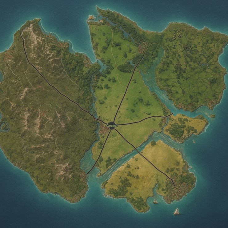
The map of Erlitou shows an island nation divided into three primary states by its major roads, all converging at a central capital located near the heart of the island. The geography of the island is highly diverse, with rugged mountains to the west, fertile plains and river systems in the north and east, and broad agricultural lowlands in the south. The surrounding seas cradle the nation’s coasts with natural harbors, mangrove estuaries, and turquoise shallows.
The capital city sits at the crossroads of Erlitou’s arterial highways, symbolizing its role as the heart of governance, culture, and commerce. From there, major roads lead outward toward coastal megacities, each situated on prominent ports that serve as hubs for trade and cultural exchange. The Erlitou River, born of tributaries in the western mountains, flows southeastward, carrying the lifeblood of trade, water, and religious significance. Smaller tributaries lace across the landscape, feeding fertile farmlands and sustaining dense populations.
Major Cities
1. Carriner (Capital Megacity, Central Heartland)
- Location: The center of the island, where all major highways converge.
- Description: Known as the “Molten Diadem’s Crucible,” Carriner is both palace-forge and urban sprawl, with tiered concentric districts radiating outward like a crucible’s rings. At its core stands the palace-forge where the Molten-Diadem matriarch adjudicates disputes and oversees innovation.
- Features:
- Forge Core Districts: Inner artisan rings where resonance valves, bronze innovations, and magical alloys are developed.
- Confluence Plaza: A civic gathering site where copper-leaf petitions are hammered for justice.
- Guild-Lattice Halls: Home to smiths, pump-keepers, and scribes that oversee state charters.
2. Jingtai (Western Coastal City)
- Location: On the western shore where mountain ridges meet the sea.
- Description: The “Mountain-Port of Bronze,” Jingtai thrives on ore extraction and smelting. Its skyline is dominated by slag chimneys and canal-fed foundries that glow by night.
- Features:
- Ore Conduit Docks: Conveyor networks that funnel processed ore directly onto trade ships.
- Resonance Chasm Mines: Canyons echoing with work chants; ore-laden caravans descend to feed Jingtai’s smelters.
- Pilgrim’s Spiral Shrine: A river-spiral crucible shrine where the faithful begin mountain treks.
3. Liusheng (Northern River City)
- Location: Along the great northern branch of the Erlitou River, near the fertile plains.
- Description: Known as the “Resonant Delta,” Liusheng is a cultural and agricultural center, powered by river currents and canal systems.
- Features:
- Grain-Terrace Markets: Storehouses and bazaars where reed-grain and river rice are exchanged.
- Water-Gong Amphitheater: Public arena built around a riverbend where chime-scribes amplify recitals.
- Floodgate Sanctuaries: Religious-engineering hybrids that double as water shrines and flood control systems.
4. Tongren (Eastern Coastal City)
- Location: On the eastern shore, where fertile plains meet coastal estuaries.
- Description: The “Harbor of Alloy Harmony,” Tongren is Erlitou’s greatest maritime hub, with sprawling shipyards and floating drydocks.
- Features:
- Bronzewind Docks: Wharf districts where Liútōng Hua couplets echo off bronze-clad ship hulls to bless voyages.
- Floating Memory Colonies: Cultural enclaves where reincarnate settlers preserve songs, cuisines, and dances from past lives.
- Tide-Stepped Foundries: Factories built directly over tidal flats, using seawater in quenching rituals.
5. Fengdu (Southern Lowland City)
- Location: At the southern coast, beyond the great farmlands and road terminus.
- Description: Called the “Granary of the Crucible,” Fengdu sits within the island’s largest agricultural plain.
- Features:
- Lotus-Silt Scribes: Canal-fed archives where humidity-reactive clay slips preserve Erlitou’s agricultural records.
- Sky-Silk Pavilions: Nurseries for steam-silk moths that supply the island’s most luxurious fabrics.
- Harvest Crucible Festivals: Dusk quenching rites where ingots are cooled and redistributed as food tokens.
Points of Interest
- Erlitou River (Central Spine): The largest river of the island, linking Carriner to Liusheng and Tongren; serves as the main artery for trade barges, ceremonial flotillas, and canal-fed foundries.
- Western Mountain Ridges: Ore-rich highlands feeding Jingtai; sacred pilgrimage paths carved into slopes mark the site of Zǐliú-Mu’s hammerfall.
- Turquoise Mangrove Estuaries (Eastern Coast): Buffer zones that protect harbors, home to fisher collectives and eel-harvesters.
- Subterranean Glow-Moss Caverns (Southern Hills): Steam-silk moth habitats used for high-value fabric production.
- Sacred Confluences: Temples where molten alloy and river water meet, marking sites of pilgrimage and judicial ritual.
Secondary Communities
Western Slag-Hollow Towns
Nestled along the foothills beneath the western mountains, these settlements house miners, smelters, and quarry workers. Villages like Huaxi Forge-Hollow and Stone-Ladle Crossing feed ore into caravans that travel to Jingtai. Their homes are built of slag-bricks glazed with turquoise patina, glowing faintly in evening fog.
Northern River Villages
The fertile north supports hamlets along tributary branches: Lotus-Fan, Nine-Reed Dock, and Hammer-Breath Ferry. Each manages irrigation sluices and rice-grain paddies. Barges ply between them daily, carrying not just food but stamped copper droplets representing collective worries offered to local shrines.
Eastern Estuary Collectives
Fishing cooperatives cluster in shallow estuary waters, such as Pearl-Tide Enclave and Eel-Shrine Jetty. These settlements manage both maritime harvests and the upkeep of tidal quenching rituals, using seawater cooled with lotus resin. They are famed for eel-oil lamps exported to Tongren.
Southern Terrace Communities
Lowland terrace-farm towns like Grain-Cross and Silt-Anchor grow reed-grain and host seasonal festivals. Apprentices from Carriner travel here for their Four-Tone Trial, since rural shrines are considered to have purer resonance tones.
Trade Routes
Great Alloy Road Network
- Radiating from Carriner, these arterial highways divide the nation into three states and connect all major coastal cities. They serve as both political boundaries and vital conduits for commerce.
- Caravans of bronze-ingot carts, steam-powered traction wagons, and river-fed aqueduct channels run along these routes.
- Roadside markets, nicknamed Cadence Stops, provide food, droplet-exchange counters, and resting crucibles for traveling artisans.
Riverine Trade Arteries
- The Erlitou River is the lifeblood of inland transport. Barges carry ore, grain, and shrine-offerings between Carriner, Liusheng, and Tongren.
- Secondary canals extend into farmlands, where smaller craft ferry silt-fertilizer and coal bundles.
- At confluence towns, trade guilds maintain “Echo Towers,” tall bronze chimneys that send resonance pulses downstream, announcing arrival schedules.
Sea Lanes
- From Tongren and Jingtai, copper-clad merchant ships embark on inter-island trade.
- Northern routes bring in frost-glass and tin, taxed heavily to discourage imbalance.
- Southern sea lanes export resonance bells, bronze alloys, and steam-silk cloth, protected by naval flotillas equipped with Quench-Veil pavilions.
Natural Resource Zones
Western Ore Belt
- Rich in copper, tin, and trace silver veins. The mountains are crisscrossed with smelter-towns and slag chutes.
- Annual “Ore Festivals” occur when newly discovered veins are blessed with molten offerings before mining begins.
Northern Grain Delta
- Fertile silt terraces provide steady harvests of reed-grain, lotus-root, and rice.
- Reed-grain is especially valued for its resilience in flood years, forming a third of the island’s food reserve.
Eastern Mangrove Reserves
- Provide sustainable charcoal, eel-fishing grounds, and pearl harvesting.
- Mangroves double as ecological shrines; guild inspectors monitor them to ensure balance between resource gathering and water purity.
Southern Steam-Silk Caverns
- Steam-silk moths thrive in glow-moss caverns beneath the southern hills. The moths spin filaments that are woven into elite fabrics worn by guildmasters and court nobility.
- Access is restricted, with apprentices undergoing resonance trials to prove worthiness before harvesting.
Central Geothermal Vents
- Found near Carriner, these vents supply both palace-forge energy and shrines.
- Smaller vents are channeled into canal boilers, powering steam-pump networks across the capital and surrounding districts.
Terrain and Landscape Details
- Western Region: Rugged and mountainous, streaked with mining scars and resonant gorges. Ore caravans move along winding cliff roads toward Jingtai.
- Northern Plains: Verdant farmlands cut by rivers, fertile and humid. Frequent fogs roll across lotus ponds, muffling village bells until they resonate through damp air.
- Eastern Estuaries: Labyrinthine mangroves and tidal flats. Trade towns perch on stilts to withstand seasonal floods.
- Southern Lowlands: Wide, sunlit terraces that shimmer gold with grain. Gentle rolling hills lead into caverns where glow-moss radiates faint green.
- Central Heartland: A mixture of river valleys, geothermal vents, and stone viaducts converging at Carriner, symbolically the crucible of both land and people.