
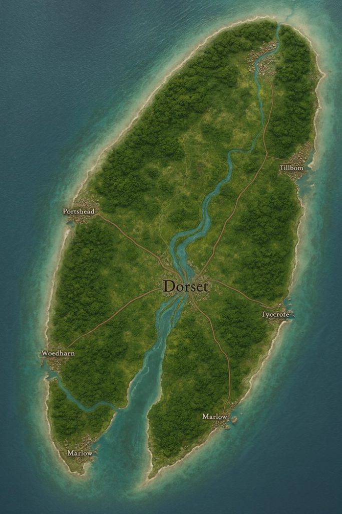
The island nation of Dorset appears elongated, with a dense green interior cut by several major rivers that flow outward toward the coast. The central hub of the nation is its capital megacity, from which a network of major roads radiates toward the coastline. These roads also serve as the defining boundaries between three major states that divide the island. Each coastal region is home to one or more major cities, and the rivers play a critical role in commerce and transportation.
Capital City
Dorset (Central Megacity)
- Located near the geographical center of the island.
- A sprawling metropolis built along the banks of the converging rivers.
- Functions as the political, cultural, and spiritual heart of the island, where the White-Spiral Line monarch presides.
- The city is also home to the largest cliff amphitheater temple of the Tri-Echo Covenant, as well as vast markets that trade goods from every coast.
- Steam-gear factories, resonance archives, and sky-docks for zeppelins and airships dominate its industrial districts.
Major Coastal Cities
Porthead (West Coast)
- Primary naval hub of Dorset.
- Known for its shipyards that construct and maintain steam-rig trawlers and zeppelins.
- Features fortified breakwaters blessed by Tri-Echo rites, making it one of the safest harbors against leviathan attacks.
- Home to a vibrant mix of immigrant enclaves that recreate past architectures in miniature, lining narrow gear-robed streets.
Woedharn (Southwest Peninsula)
- Built along tidal rivers that flow into sheltered coves.
- Famous for coral-seeded reef gardens that calm storm surges and protect the southern trade routes.
- Known for quarrywright guilds that specialize in chalk dwellings and gyroscopic keel stabilizers.
- The Spray Circuit (coming-of-age sea journey for the Tide-Hollow Kin) traditionally begins here.
Marlow (South Coast)
- A bustling mercantile city and major agricultural hub, located near sheltered plains and fertile tide-vales.
- Known for producing salt-tolerant barley and kelp-dye textiles.
- Hosts the annual Tide-Reckoning Festival, with lantern kites, sea drums, and cliff light-shows visible from across the southern sea.
- Also a key hub for ferry traffic connecting offshore islands.
Tyecroft (East Coast)
- Dorset’s cultural port, famed for amphitheater performances and triskelion pageants.
- Known for Othic Script archives carved into polished limestone, housing centuries of maritime law and ancestral oaths.
- Trade goods from foreign archipelagos often arrive here, making it the most cosmopolitan of the coastal cities.
- Houses a great sky-dock tower where griffon riders and zeppelins share space.
Tillbom (Northeast Coast)
- Built at the mouth of a major river system.
- Known for its freshwater fisheries, pearl-ink workshops, and limestone dye-vats powered by geothermal springs.
- Serves as a key inland-to-sea trade gateway, funneling agricultural goods and quarried chalk through riverborne barges.
- Also houses one of the largest inland hot-spring communal bathhouses.
Rivers and Commerce
- Central River Confluence: Several rivers merge at Dorset’s capital, making it the hub for barge-based commerce. Grain, quarried chalk, kelp-dye barrels, and pearl-ink shipments all flow through these arteries.
- Northern River System (Tillbom): Facilitates bulk transport of grain and dyed textiles to coastal ports.
- Southern Rivers (Woedharn & Marlow): Carry quarry stone, salt, and reef-garden produce inland, fueling construction and naval outfitting.
- Western Tributaries (Porthead): Supply shipyards with timber, ores, and enchanted chalk tiles for naval construction.
Points of Interest
- Tri-Echo Amphitheaters: Dotting the cliffs across the island, used for worship and oath-keeping rituals.
- Resonant Breakwaters: Engineered stone defenses at major ports, humming with protective chants against storms and leviathans.
- Reef Gardens: Coral-shaped fortifications offshore, tended by stonemasons and consecrated with tide-magic.
- Royal Cairn: Located near the capital, it houses chalk plates inscribed with the maternal lineage of the White-Spiral Line monarchs.
- Sky-Docks: Massive towers in Dorset City and Tyecroft where zeppelins, griffons, and airships dock.
- Quarryworks: Inland operations that provide chalk, flint, and limestone for construction, often blessed by resonance rites.
- Tide-Reckoning Festival Grounds: In Marlow, where the largest celebrations of Dorset’s cultural calendar take place.
Secondary Communities
Cliffhaven (Northwest Cliffs)
- A smaller community carved directly into chalk escarpments.
- Renowned for lighthouse keepers and bell-founders who maintain foghorn towers.
- Acts as a staging point for leviathan-watch patrols guarding western sea lanes.
Barrowmere (Central Highlands)
- Inland settlement near natural limestone sinkholes and freshwater springs.
- Known for producing indigo sea-clay and pearl-ink pigments.
- Houses a large amphitheater quarry, where resonance testing ensures stone is free of oath-fractures before export.
Saltmarsh (South Coast between Marlow and Woedharn)
- Located along low-lying tidal flats.
- Major salt-harvesting center; evaporation pans spread across the landscape.
- Saltmarsh guilds produce ceremonial rope bracelets for Tri-Echo rites, dyed in sea-foam hues.
Eastmere (Inland east of Tyecroft)
- Agricultural district where salt-resistant barley thrives in wind-fed irrigation channels.
- Supplies grain for both domestic needs and overseas export.
- Known for its communal bathhouses, heated by geothermal vents.
Gullspire (Northern Headland near Tillbom)
- Small but vital settlement built around a sky-dock outpost.
- Griffon riders and zeppelin crews use it as a relay station for long-haul journeys north across the archipelagos.
- Its triple-bell signal tower is a landmark for incoming trade fleets.
Trade Routes
- Central Radiating Roads: Major stone-paved roads fan out from the capital Dorset, dividing the nation into three states.
- North Road: Connects Dorset → Tillbom → Gullspire, carrying agricultural goods, pearl-ink, and chalk to the northeast port.
- East Road: Connects Dorset → Tyecroft → Eastmere, handling imported foreign goods, cultural artifacts, and luxury trade.
- South Road: Connects Dorset → Marlow → Saltmarsh, facilitating salt, textiles, and agricultural surpluses.
- West Road: Connects Dorset → Porthead → Woedharn, transporting naval materials, timber, and reef-garden harvests.
- Rivers as Trade Arteries:
- Barges ferry chalk blocks, grain, kelp dye, and pearl-ink from interior valleys to coastal shipyards.
- River docks along Tillbom and Marlow are lined with limestone warehouses carved into cliffs.
- Maritime Trade Lanes:
- Western sea routes run from Porthead to Abbeville and other island nations.
- Eastern routes carry Tyecroft’s cultural exports and grain shipments toward Dawenkou and beyond.
- Southern coastal routes transport Marlow’s salt, reef goods, and textiles.
- Sky Routes:
- Griffon riders and zeppelins connect Dorset’s sky-docks (Dorset City, Tyecroft, Gullspire).
- Racing airship corridors spiral through labyrinthine valleys, celebrated during annual tournaments.
Natural Resource Zones
Chalk Quarries (Interior & Cliffhaven)
- Dorset’s wealth rests on chalk, quarried for stone memory rites and resonance architecture.
- Exported as blocks or carved into covenant tiles.
Flint Uplands (Central Highlands)
- The central interior has fields of jagged flint shards.
- Flint sparks against stray magical currents at dusk, producing star-field light shows.
- Harvested for tool-making, spark-charms, and defensive rune wards.
Salt Flats (South Coast near Saltmarsh)
- Provide Dorset with ceremonial and trade salt.
- Over-harvesting risks weakening tidal barriers, so Tri-Echo inspectors regulate the practice.
Reef Gardens (Woedharn Coast & Southern Shoals)
- Coral-seeded fortifications absorb tidal energy and produce shell harvests.
- Stonemasons shape reefs into spirals for both protection and Tri-Echo symbolism.
Geothermal Vents (Eastern Rift-Vale)
- Hot springs feed communal bathhouses and kelp-dye vats.
- Also tapped for alchemical processes requiring constant heat.
Forested Valleys (North Interior)
- Though most of Dorset is chalk and upland, sheltered valleys support managed woodland.
- Supplies timber for shipbuilding and airship frame construction.
Terrain and Environmental Notes
- Chalk Escarpments: Sheer coastal cliffs riddled with echoing sea caves; naturally resonant amphitheater bowls dot their lengths.
- Rift-Vales: Narrow, fertile valleys sheltered from coastal winds, used for barley cultivation and livestock herding.
- Fog Moorlands (Interior): Mist-shrouded, dotted with geothermal vents. Serve as dye-production centers but are treacherous to cross without kin barometers.
- Breeze-Swept Uplands: Spark with magical discharges at dusk; locals treat these as natural omens.
- Coastal Breakwaters: Engineering marvels maintained by state taxes, humming with resonance chants that stabilize tides and block erosion.
Additional Notes
- State Boundaries: The major roads from Dorset divide the nation into three principal states. Each state has its own focus:
- North State (Tillbom & Gullspire): Agriculture, pearl-ink, griffon sky-routes.
- East State (Tyecroft & Eastmere): Culture, archives, international trade.
- South/West State (Marlow, Woedharn, Porthead, Saltmarsh): Naval power, salt, quarrywright shipyards, and reef defense.
- Cultural Patterns:
- Inland communities prize quarrywright craftsmanship.
- Coastal communities emphasize oath-keeping and Tri-Echo rites tied to the sea.
- Sky-dock towns (Tyecroft, Gullspire, Dorset City) blend griffon lore with steam-gear innovation.