
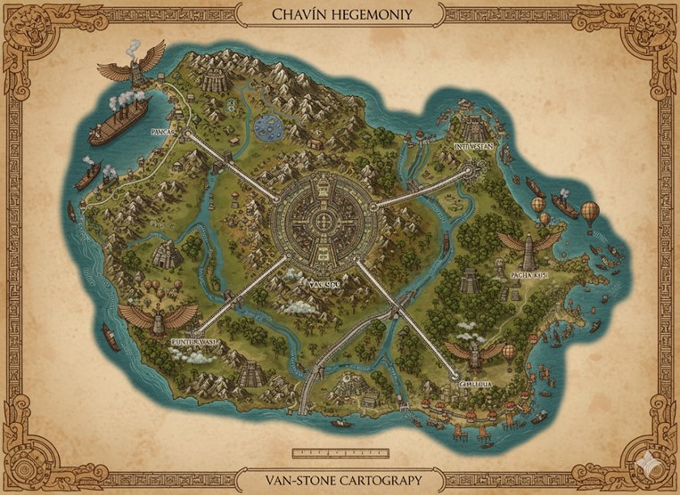
This national map of the Chavín Hegemony, titled in the border as a work of “Van-Stone Cartography,” presents a detailed topographical and political view of the island nation. The map is rendered in an aged, hand-drawn style, consistent with the culture’s focus on stone and ancient traditions. A prominent mountain range, the spine of the nation, dominates the western and central parts of the island, with dense, mist-shrouded jungles covering the eastern lowlands.
The cartography highlights a highly organized and centralized society. A massive, circular capital megacity, Van-Koru, sits at the island’s heart, acting as the nexus for a network of great stone roads that radiate outwards to the coast. These roads are marvels of engineering, cutting through mountains and jungles to connect the capital with its vital coastal ports. They also serve as the political boundaries for the nation’s primary states. The island’s major rivers are shown as vital arteries of commerce, teeming with ships and barges that supplement the road network. The map is framed with intricate, geometric patterns and stylized representations of the divine predators—the eagle and the jaguar—reinforcing the severe, monolithic, and spiritual aesthetic of the Chavín culture.
Major Cities
Van-Koru (The Labyrinthine Heart) Located at the exact center of the island and the road network, Van-Koru is the political, spiritual, and cultural heart of the Chavín Hegemony. It is a true megacity, built in a series of concentric circles around the Grand Labyrinth, the most sacred temple dedicated to the deity Lanzón. The city’s architecture is cyclopean and severe, with towering stone structures that function as both administrative centers and conduits for the Path of the Labyrinthine Eye. As the seat of the High Shaman and the ruling class of the “Transformed,” Van-Koru is where all major decisions are made and where the most profound spiritual rituals are undertaken. It is a city of echoes, stone, and reverent fear, where the hum of industry is secondary to the low, resonant chanting of the Qor-Tek priests.
Paucar (The Western Gate) Situated on the rugged western coast, Paucar is the Hegemony’s primary naval base and a heavily fortified port city. Its formidable stone seawalls are built to withstand both the crashing waves of the endless ocean and any potential invaders. Paucar is a city of discipline and vigilance, home to the shipyards that build the Hegemony’s steam-powered vessels and the barracks of its elite shaman-warriors. While trade occurs here, it is strictly regulated, with a focus on importing raw materials needed for the nation’s industry and exporting magically resonant obsidian mined from the nearby mountains.
Intiñan (The Sky-Piercing Port) Nestled in a northern bay at the foot of the highest mountain peaks, Intiñan is the main hub for the nation’s air travel. The city is famous for its massive mooring towers, where great Zeppelins and Airships are docked, and for the wide, flat plateaus that serve as launching points for Hot Air Balloons and Griffon riders. Intiñan controls the trade of rare metals and gems mined from the mountains, and its markets are filled with goods from the sky-faring merchants who brave the treacherous mountain passes. It serves as a vital link for transporting goods and personnel over the impassable terrain of the island’s northern spine.
Pacha Kusi (The Verdant Port) Located on the northeastern coast and surrounded by teeming jungle, Pacha Kusi is the center of the Hegemony’s agricultural and alchemical industries. The city’s port is constantly busy with barges moving up and down the river, bringing harvests of rare psychoactive plants, exotic woods, and potent alchemical ingredients from deep within the jungle to be processed and shipped. The air in Pacha Kusi is thick with the scent of strange flowers and the bubbling of alchemical workshops. It is a city where the untamed energy of the jungle is harnessed and refined by the rigid discipline of Chavín society.
Chullachaqui (The Southern Spire) Guarding the southeastern peninsula, Chullachaqui is a major trade port known for its unique blend of commerce and spiritualism. The city is built around a series of towering, lighthouse-like temples that guide ships through the treacherous coastal waters. It is the primary point of contact for the few outsiders permitted to trade with the Hegemony, making it the most cosmopolitan city in the nation, though still deeply xenophobic by outside standards. Chullachaqui is also the main exporter of finished goods, such as intricate jade jewelry, ceremonial staffs, and stone tablets inscribed with the Van-Stone script.
Euntiñanti (The River’s Mouth) Positioned at the mouth of the great southwestern river, Euntiñanti is a sprawling city that serves as the nexus of the island’s extensive riverine commerce. It is a city of bridges, canals, and massive stone warehouses. Goods from all over the southern and western interior flow down the river to Euntiñanti, where they are sorted, taxed, and loaded onto ocean-going vessels. The city’s population is largely composed of the hardy Kor-Runa who pilot the river barges, their deep, chanting voices a constant presence along the waterfront.
Points of Interest
The Great Stone Roads These four massive causeways are the arteries of the nation, connecting Van-Koru to the coastal cities. More than just roads, they are monuments of Chavín power and resolve, perfectly straight and paved with massive, interlocking stones. They serve as the primary conduits for legions of shaman-warriors, trade caravans, and pilgrims. The roads also function as the official borders for the nation’s internal states, dividing the island into the Northwestern State, Southwestern State, and the vast Eastern Jungle State.
The Major Rivers Two major river systems are depicted. The first originates in the northern mountains and flows east through the jungle, emptying into the sea near Pacha Kusi. The second, larger system begins in the central highlands near Van-Koru and splits, with one branch flowing southwest to Euntiñanti and the other flowing southeast past Chullachaqui. These rivers are the lifeblood of the interior, used extensively for transporting bulk goods like timber, stone, and agricultural products on large, steam-powered barges.
Temples and Labyrinths Beyond the capital, numerous smaller temples and ancient, cyclopean ruins dot the landscape, marked on the map as significant structures. These sites are often built over convergences of magical ley lines or at locations of historical or spiritual importance. Many of the more remote sites are active Labyrinths, used for the initiation rites of the Path of the Labyrinthine Eye, where aspiring shamans undertake their dangerous vision quests in isolation.
Air and Sea Commerce The map vividly illustrates the nation’s methods of trade and travel. The oceans are populated with large, steam-powered merchant ships, indicating a robust maritime trade network. In the skies, particularly in the mountainous regions, Hot Air Balloons and larger Airships are common, showcasing the Chavín’s mastery of both magic- and steam-driven transportation to overcome the challenging geography of their island home.
Secondary Communities
Beyond the major cities, the island is dotted with numerous smaller, specialized communities that form the backbone of the Hegemony’s economy and spiritual life.
- Quarry Towns: Settlements like Rumi-Nawi (Stone-Eye) are found at the base of the mountains. These austere towns are dedicated entirely to the quarrying and shaping of the massive stone blocks used for the nation’s temples, cities, and roads. The population is almost exclusively Kor-Runa, whose endurance and connection to stone make them masters of this craft.
- Highland Agricultural Villages: Nestled in high-altitude valleys are villages such as Sara-Pampa (Maize-Plain). They utilize extensive, ancient terrace farming systems to cultivate hardy staples like maize, quinoa, and potatoes. These communities are isolated and self-sufficient, living lives dictated by the seasons and ancient traditions.
- Jungle Outposts: Deep within the eastern jungles, fortified outposts like Sacha-Wasi (Jungle-House) serve as hubs for logging rare woods and harvesting alchemical and spiritual flora. These are dangerous places, protected by shaman-warriors against the predatory magical beasts that roam the forests. The most sacred of these is a single, hidden valley where a priestly caste cultivates the revered Sacred Cactus.
- River Junction Towns: At the confluence of smaller tributaries and the major rivers, towns like Yaku-Chaka (Water-Bridge) have grown. They serve as local collection points where goods from more remote areas are transferred from smaller rafts and barges onto the larger steam-powered vessels that travel the main waterways.
Expanded Trade Network
The flow of goods and people is not limited to the great roads and rivers. A more complex network ensures the entire nation is interconnected.
- Lesser River Routes: An intricate network of smaller rivers and streams is navigable by specialized shallow-draft barges and rafts. These routes are crucial for connecting the deep jungle outposts and highland valleys to the major river arteries, allowing for the transport of timber, herbs, and agricultural goods.
- The Sky-Paths: High-altitude trade is conducted via “Sky-Paths”—designated routes through the treacherous mountain passes. These are traversed almost exclusively by Griffon riders carrying high-value, low-weight cargo like messages, rare gems, and alchemical formulas, and by the large Airships that move bulkier goods between highland mining communities and the hub city of Intiñan.
- Ancient Tunnel Roads: A secret network of subterranean tunnels, known only to the initiated Transformed and high-ranking Kor-Runa, connects key temples, military strongholds, and the capital of Van-Koru. These Labyrinthine passages allow for the swift, unseen movement of shaman-warriors and sacred relics, bypassing any surface threats.
- Coastal Shipping Lanes: A constant stream of smaller, durable steam-ships and traditional reed boats hug the coastline, facilitating trade between the major ports and smaller fishing villages that are not connected to the main roads. This coastal traffic is essential for distributing food and supplies along the nation’s periphery.
Natural Resource Zones
The Hegemony’s wealth and power are derived from the unique and potent resources found across the island.
- The Obsidian Fields: Located in the volcanic and geothermally active mountains of the northwest, these fields are the primary source of the magically resonant volcanic glass that is a key Chavín export. The land here is harsh and broken, often shrouded in volcanic steam.
- The Jade Veins: The central highlands surrounding Van-Koru are riddled with veins of precious, spiritually significant jade. The locations of these mines are a state secret, guarded fiercely by the theocracy and worked by trusted artisans.
- The Ironwood Forest: A specific region within the northeastern jungle is famed for its Ironwood trees, whose timber is as dense as metal and resonates strongly with the magic of endurance. This wood is used for the hulls of elite naval vessels and the ceremonial staffs of the Transformed.
- The Sunken Coast Mangroves: The swampy river deltas of the southwest are home to a unique ecosystem of mangrove forests. These areas provide not only vital protection from ocean storms but also yield rare alchemical reagents from their bark and roots, as well as pearls from the giant oysters that live among them.
Detailed Terrain Features
The island’s landscape is as much a character in the nation’s story as its people.
- The Silent Fang Peaks: This is the name given to the primary mountain range that forms the island’s spine. These are geologically young, jagged peaks that soar to heights where the air is thin and cold. The range is notorious for unpredictable, violent storms and is considered the physical manifestation of Lanzón’s untamable power.
- The Whispering Jungle: The vast expanse of rainforest in the east is known as the Whispering Jungle. Its canopy is so dense that the forest floor is in a perpetual twilight. The name comes from the constant, rustling sound of the wind through the leaves, which locals believe to be the disembodied voices of the forest’s innumerable spirits. The jungle is a living labyrinth, full of ancient, vine-choked ruins and dangerous, chimeric beasts.
- The Cloud-Veil Valleys: The high-altitude valleys where most Chavín villages are located are often shielded from the outside world by a near-permanent layer of thick clouds and mist. This “Cloud-Veil” creates a humid, temperate microclimate ideal for terrace farming and contributes to the culture’s deep sense of isolation and mystery.
- Geothermal Vents and Pools: The volcanic activity in the western mountains creates numerous geothermal vents and hot springs. These sites are considered sacred, representing the living breath of the mountain. The Kor-Runa use the naturally heated caverns and pools as communal hatcheries for their eggs, a practice that is central to their life cycle.