
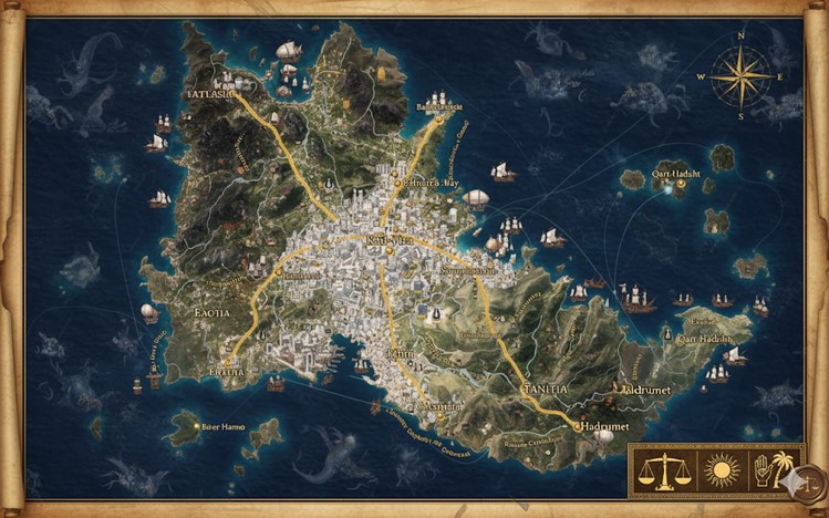
The island nation of Carthage is a vast and diverse landmass, dominated by a central capital megacity with a sprawling urban core. From this central hub, a network of major roads extends outwards, connecting it to various coastal cities and dividing the nation into distinct states. The landscape is characterized by a mix of rugged mountains, fertile plains, and extensive coastlines, all of which are depicted in great detail on the map. The nation’s geography is not only a testament to its natural beauty but also a reflection of its strategic importance as a hub for maritime trade and commerce.
The map highlights the nation’s well-developed infrastructure, with roads and rivers serving as vital arteries for transportation and trade. The presence of numerous ships and airships along the coastlines and waterways underscores the nation’s thriving economy and its role as a major player in regional and international trade. The inclusion of various points of interest, such as ancient ruins, lighthouses, and fortified outposts, adds depth and historical context to the map, inviting exploration and discovery.
Major Cities
- Kad-Vira: The capital and largest city of Carthage, Kad-Vira is a sprawling megacity located in the heart of the island. It serves as the nation’s political, economic, and cultural center, with a dense urban core and extensive suburban areas. The city is a hub of activity, with numerous trade routes and transportation networks converging within its borders. Its strategic location and well-developed infrastructure make it a vital center for commerce and governance.
- Atlasia: Situated in the northern part of the island, Atlasia is a major coastal city known for its bustling port and strategic military importance. It is a key center for naval operations and maritime trade, with a well-fortified harbor and a strong naval presence. The city’s location on the coast makes it a vital gateway for trade and a critical defensive outpost.
- Baotia: Located in the western part of the island, Baotia is a major agricultural and industrial center. The city is surrounded by fertile plains and rich natural resources, making it a hub for farming, mining, and manufacturing. Its strategic location on a major river and its proximity to key trade routes make it an important center for commerce and economic development.
- Tanifia: Situated in the southern part of the island, Tanifia is a major cultural and religious center. The city is home to numerous temples, monuments, and historical sites, making it a popular destination for pilgrims and tourists. Its rich cultural heritage and vibrant arts scene make it a hub of creative expression and intellectual discourse.
Points of Interest
- The Great Harbor: A vast, deep-water bay that serves as the main port for the capital city of Kad-Vira. It is a bustling hub of maritime activity, with numerous ships and airships constantly arriving and departing. The harbor is protected by towering cliffs and a series of fortified outposts, making it a secure and strategic location for trade and naval operations.
- The Atlasian Mountains: A rugged mountain range that dominates the northern part of the island. The mountains are rich in mineral resources, with numerous mines and quarries scattered throughout the region. They are also home to several ancient ruins and historical sites, making them a popular destination for adventurers and historians.
- The River Hanno: A major river that flows through the heart of the island, connecting the capital city of Kad-Vira to the coastal city of Baotia. The river is a vital artery for trade and transportation, with numerous barges and ships navigating its waters. It is also a source of irrigation for the surrounding farmlands, making it a critical resource for the nation’s agricultural sector.
- The Sunken City of Seren: The ruins of an ancient city that was submerged by a cataclysmic event centuries ago. The city is located off the coast of Tanifia and is a popular destination for underwater exploration and archaeological research. The ruins are said to hold valuable treasures and ancient artifacts, attracting adventurers and treasure hunters from across the nation.
- The Lighthouse of Hadrumet: A towering lighthouse located on the southeastern coast of the island. The lighthouse serves as a beacon for ships navigating the treacherous waters of the region, guiding them safely to port. It is a symbol of the nation’s maritime heritage and its commitment to safe and efficient trade.
Terrain Details
The island of Carthage is a land of dramatic contrasts. The northwest is dominated by the rugged and imposing Atlasian Mountains. These are not gentle, rolling hills but sharp, jagged peaks with deep valleys, suggesting a geologically active history. The peaks are high enough to capture atmospheric moisture, feeding the numerous streams that cascade down their slopes. This region is likely difficult to traverse except through established passes and roads, making control of these routes vital.
To the west and south of the central megacity, Kad-Vira, the terrain softens into the expansive Plains of Baotia. This region is a vast, fertile breadbasket, characterized by wide-open fields, gentle slopes, and the broad, meandering path of the River Hanno. The soil here appears dark and rich, ideal for large-scale agriculture.
The southeastern region of Tanifia is a mix of rolling hills, coastal plains, and dense woodlands. The coastline here is more varied than elsewhere, featuring dramatic white cliffs, sheltered coves, and the large delta of the River Asdrubal. This geography makes it ideal for numerous smaller ports and fishing villages. The interior hills are covered in what appear to be ancient, dense forests.
Off the main island, numerous smaller islands and archipelagos dot the surrounding seas. The islands to the northeast, labeled Qart-Hadasht, appear rocky and volcanic, while the islands to the southeast near Hadrumet are greener and seem more temperate. The waters immediately surrounding the main harbor are depicted as calm, a sign of Baal-Tanit’s favor, but further out, the presence of monstrous sea beasts indicates that the open ocean is treacherous and wild, making established and protected trade routes essential for survival.
Secondary Communities
Beyond the major state capitals, several secondary communities are visible on the map, each serving a specific purpose within the nation’s economy and defense.
- Belmur’s Way: Located north of Kad-Vira, this appears to be a major fortified town or citadel built along the primary road leading into the Atlasian Mountains. Its strategic position suggests it serves as a military garrison and a tollgate, controlling the flow of traffic and resources from the northern mining districts.
- Barnahus: Situated at the foothills of the Atlasian Mountains in the state of Baotia, this community is likely a large mining and lumber town. It sits at the terminus of a mountain road and near a river, positioning it as a collection point for raw timber and ore before they are transported toward the capital.
- Eretna: A significant town in southern Baotia, located on the River Hanno. Its position on the river and road between Kad-Vira and the western coast suggests it’s a vital agricultural hub and river port, where grain and other foodstuffs from the Plains of Baotia are loaded onto barges for shipment.
- Gishto: Found in the southern hills of Tanifia, this town is nestled deep within a forested region and situated on the River Asdrubal. It is likely a center for valuable timber, exotic woods, and perhaps luxury goods like dyes or spices harvested from the surrounding forests.
- Hadrumet: While a major city, its role appears to be that of a crucial southern port and lighthouse station. Positioned on the southeastern tip of the island, it is the first and last point of contact for ships braving the southern sea routes, making it a critical naval outpost and a center for ship repair and resupply.
- Baecart: A town on the largest of the Qart-Hadasht islands. Its fortified appearance and harbor suggest it is a forward naval base and a center for fishing or harvesting rare aquatic resources from the surrounding archipelago.
Trade Routes
Carthage is crisscrossed by a network of vital trade routes by land, river, and sea, facilitating the flow of goods that is the nation’s lifeblood.
- The Northern Ore Road: The major road running from Kad-Vira north through Belmur’s Way and into the Atlasian Mountains. This route is essential for transporting iron, copper, silver, and precious metals from the mountain mines to the forges and markets of the capital.
- The Hanno River Route: A critical waterway for commerce. Barges and riverboats constantly move along the River Hanno, carrying grain, livestock, and produce from the agricultural heartland of Baotia, with towns like Eretna serving as key loading docks. This food supply is crucial for feeding the massive population of Kad-Vira.
- The Southern Spice & Timber Route: The River Asdrubal and the road running through Gishto facilitate the transport of high-quality timber, resins, and other valuable forest products from the Tanifian woodlands to the capital and the port of Hadrumet for export.
- The Coastal Maritime Loop: A heavily trafficked sea route connects the major coastal cities. Ships transport finished goods, textiles, and weapons from Kad-Vira to Atlasia and Hadrumet. In return, Atlasia sends naval supplies and imported northern goods, while Hadrumet ships luxury items and goods from southern trade partners.
- The Qart-Hadasht Run: A naval-patrolled sea lane connecting the mainland to the Qart-Hadasht islands. This route is likely used for supplying the outpost at Baecart and transporting whatever unique resources—perhaps rare fish, obsidian, or alchemical reagents—are harvested from the volcanic islands.
- Airship Commerce: Numerous airships are depicted, particularly around the major cities. They likely represent a premium mode of transport for high-value, low-weight goods (like important documents, precious gems, or powerful alchemical components) and for wealthy or important individuals who wish to travel quickly and avoid the dangers of the roads or seas.
Natural Resource Zones
The prosperity of Carthage is built upon the exploitation of its rich and varied natural resources.
- Atlasian Mineral Belt: The entire Atlasian Mountain range is a zone rich in mineral wealth. The map indicates numerous mining operations. This region is the primary source of the nation’s iron for weapons and ships, copper for tools and wiring, and the gold and silver that fuel its powerful economy.
- Baotian Breadbasket: The vast, fertile plains surrounding the River Hanno are the nation’s agricultural heartland. This zone produces the massive quantities of grain, wine (from vineyards), olives, and other crops necessary to sustain the population and for export.
- Tanifian Old-Growth Forests: The dense forests in the state of Tanifia are a key resource for timber. The ancient cedar and oak trees are essential for building Carthage’s formidable navy and merchant fleets. The deeper woods likely also provide rare alchemical ingredients, valuable animal pelts, and exotic woods for luxury goods.
- Coastal Fisheries: The entire coastline is a massive resource for fishing. Different regions likely specialize in different catches. The calmer waters of the Great Harbor and southern coves might be used for aquaculture, while the deeper waters off the northern coast are harvested by fleets for large deep-sea fish.
- Hadrumet Pearl Beds: The sheltered waters and islands near Hadrumet in the southeast could plausibly be home to rich pearl diving grounds, providing a key luxury export.
- The Sunken City of Seren: Located off the coast of Tanifia, this is a unique resource zone. While dangerous, adventurers and state-sanctioned salvagers likely recover ancient artifacts, rare metals, and magical items from these underwater ruins, representing a high-risk, high-reward enterprise.