
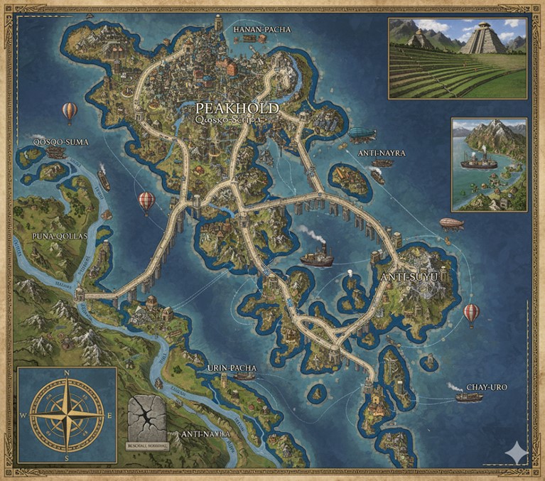
This national map of the island nation of Andean depicts a large archipelago characterized by a central landmass and numerous surrounding islands of varying sizes. The geography is dominated by a mountainous and varied terrain, with significant bodies of water separating the landmasses. An intricate network of roads and bridges, depicted as stone causeways, connects the islands, indicating a high level of engineering and interconnectedness. Major rivers flow from the interior of the larger landmasses to the sea, and numerous ships, including steamships, hot air balloons, and zeppelins, illustrate active commerce and travel throughout the nation. The map is divided into several states, with their boundaries clearly delineated by the major road networks. A compass rose in the lower-left corner indicates orientation, and inset images provide more detailed views of the nation’s characteristic terraced agriculture, a coastal city, and a significant architectural structure.
Major Cities
- Peakhold (Qosqo-Suma): Located near the center of the map on the largest island, Peakhold is the capital megacity of Andean. It is the central hub from which all major road networks radiate, connecting it to the coastal regions and other major cities. The depiction shows a densely populated urban area built at a high elevation, consistent with its name. The city is situated at the confluence of several land routes and appears to be the primary political and commercial center of the nation. The label “Qosqo-Suma” is also associated with this location, which is noted in the lore as a terraced metropolis of over 10 million inhabitants.
- Hanan-Pacha: Situated in the northern part of the central island, Hanan-Pacha is a significant city connected directly to Peakhold by a major road. Its location suggests it may be a key center for the northern territories of Andean.
- Anti-Nayra: This name appears in two separate locations on the eastern side of the map, suggesting it could be a state or a region with multiple significant settlements rather than a single city. One major coastal city is located in the northeastern part of the archipelago, and another is situated on a large island to the south. Both are connected by the main road system.
- Anti-Suyu: Located on a large eastern island, Anti-Suyu is a major city connected by an extensive network of bridges and roads. Its position indicates it is a significant hub for the eastern part of the nation.
- Chay-Uro: Situated on an island in the southeastern corner of the map, Chay-Uro is a coastal city and a terminus for one of the major road arteries. Its location suggests it is an important port for maritime trade.
- Urin Pacha: This city is located on the southern part of the main central island, connected to the road network.
- Puna-Qollas: Located on the western side of the main island, Puna-Qollas is a significant city connected by road to the central capital. It appears to be situated near the headwaters of a major river system.
Points of Interest
- Rivers: The map shows several major rivers flowing from the interior highlands to the coast. The longest river system appears to originate near Puna-Qollas and flows westward, with several tributaries. Other significant rivers are shown in the southern and western regions. The presence of numerous ships on the rivers indicates they are vital arteries for commerce and transportation. The rivers are named with labels such as “Apurima,” “Urubam,” “Vilcanot,” “Maranon,” and “Mantaro.”
- States: The major roads serve as the boundaries for at least three states. The names on the map that likely correspond to these states are Hanan-Pacha, Anti-Nayra, Anti-Suyu, Urin Pacha, and Puna-Qollas, which appear to be both city and regional names.
- Rockfall Memorial: In the lower left quadrant of the map, there is a symbol of a cracked mountain with the label “Rockfall Memorial.” This marks the location of the historical event detailed in the lore, serving as a significant cultural and historical landmark.
- Inset Images:
- The top-right inset displays a large, terraced pyramid-like structure in a lush, mountainous environment, representative of the architectural style and agricultural practices of Andean.
- The middle-right inset provides a closer view of a coastal settlement nestled at the base of steep, snow-capped mountains, with steamships in the harbor. This highlights the nation’s maritime capabilities and its settlement patterns in the rugged terrain.
- Commerce and Travel: The map is bustling with activity. Steamships of various sizes are depicted on the open seas and rivers, indicating a thriving maritime trade. Hot air balloons and a large zeppelin are shown in the skies, representing the use of air travel. This variety of transportation methods underscores the steampunk and high-magic technological level of the nation.
This national map of Andean provides a comprehensive overview of its geography, infrastructure, and economic activities. The terrain is largely mountainous, particularly across the larger central island and the eastern landmasses, with peaks, valleys, and terraced slopes. Rivers carve through these landscapes, creating fertile basins and pathways for inland commerce. The surrounding ocean features numerous smaller islands and a deep blue hue that suggests vast depths. The intricate network of stone bridges and causeways not only connects major cities but also extends to smaller settlements, demonstrating a highly integrated infrastructure across the archipelago.
Secondary Communities
Beyond the major cities like Peakhold, Hanan-Pacha, Anti-Nayra, Anti-Suyu, Chay-Uro, Urin Pacha, and Puna-Qollas, the map reveals a scattering of smaller towns and villages. These communities are typically found:
- Along River Banks: Numerous smaller settlements are visible along the major rivers such as the Apurima, Urubam, Vilcanot, Maranon, and Mantaro. These communities likely rely on the rivers for irrigation, fishing, and as transportation routes for local goods.
- In Terraced Valleys: Many communities are nestled within the valleys between mountain ranges, often characterized by the distinct terraced agriculture shown in the inset images. These are likely agricultural hubs, supporting the larger urban centers with food production.
- Coastal Outposts: Smaller coastal towns dot the various islands, serving as fishing villages, minor ports, or strategic lookout points.
- Highland Settlements: Some settlements appear to be perched precariously on mountain slopes or within high-altitude plateaus, indicating communities adapted to the rugged highland environment. These might be mining communities or remote religious outposts.
Trade Routes
The map distinctly illustrates a dynamic and interconnected trade network, utilizing a combination of land, sea, and air routes:
- Road Networks (Land/Bridge Routes): The extensive system of stone roads and bridges forms the backbone of Andean’s internal trade. These routes connect Peakhold, the central capital, to all major cities and numerous secondary communities.
- Goods like stone-crafted items, alchemical remedies, and steam-powered machinery from urban centers would travel outwards.
- Agricultural produce, raw minerals, and unique goods from specialized highland or valley communities would be transported to the cities for consumption or export.
- The roads also facilitate the movement of griffon-riding couriers, which are mentioned in the lore as part of the trade and communication network.
- Riverine Trade: The rivers are clearly marked with numerous steamships, indicating significant internal commerce.
- Rivers like the Apurima, Urubam, and Mantaro would carry goods between inland agricultural or mining centers and coastal ports, linking diverse regions.
- Logs, processed materials, and food items would be transported efficiently via these waterways.
- Maritime Trade Routes (Oceanic): Steamships are shown traversing the open waters between the various islands and along the coastlines.
- These routes are crucial for connecting the 73 island countries of Saṃsāra, facilitating exports from Andean such as stone goods, steam-powered devices, and alchemical remedies.
- Imports of exotic materials or goods from other nations would arrive via these sea lanes.
- Aerial Trade Routes: Hot air balloons and a large zeppelin are visible, indicating the use of airships for long-distance and potentially high-value cargo transport.
- These would connect major cities and bypass difficult land or sea routes, especially across mountainous regions or open ocean.
- Such routes would be used for express deliveries, military movements, or luxury goods.
Natural Resource Zones
Based on the terrain and existing lore, several natural resource zones can be inferred:
- Mountainous Regions (Central & Eastern Islands): These areas are likely rich in stone, precious metals, and minerals. Given the Qosqo-Pacha’s obsidian-like skin and the emphasis on stonecraft and mining in their culture, volcanic rock, obsidian, jade, and other ores (copper, silver, gold, electrum, platinum, rhodium for coinage and gear) would be abundant. Mountain ley lines, crucial for magic flow, are also concentrated here.
- Terraced Valleys and River Basins: These fertile areas are prime for agricultural production. The terraced fields, visible in the inset, would yield bountiful harvests of various crops, sustained by magical irrigation and steam-powered farming techniques. These are the “harvest seeds” Intayra tends.
- Geothermal and Volcanic Areas: The lore mentions geothermal springs and volcanic activity as sources for steam. These zones would provide elemental fire and water for steam production, driving the nation’s industrial age. They also provide unique minerals and perhaps specialized alchemical ingredients.
- Forests/Jungles (Lower Elevations and Remote Areas): Though less prominent on this map, the lore mentions “forgotten ruins dot remote jungles at lower elevations.” These areas would likely offer timber, medicinal herbs, and exotic flora/fauna, potentially guarded by unique monsters.
- Coastal and Underwater Regions: The coastlines and hinted “underwater extensions with domed settlements” would provide marine resources such as fish, pearls, and unique aquatic alchemical ingredients.
Additional Information About the Terrain
- High Magic Flow: The map visually reinforces the concept of “high magic” by depicting a landscape that appears shaped by magical forces. The lushness of the valleys alongside the rugged mountains suggests a powerful, life-sustaining magic presence.
- Interconnected Waterways: The numerous rivers and their tributaries, along with the extensive system of bridges, demonstrate a masterful integration of natural waterways into the nation’s infrastructure. This suggests a significant control over water flow, likely enhanced by earth and water magic.
- Architectural Integration: The cities, especially Peakhold, are shown integrated into the mountainous landscape, reflecting the Qosqo-Pacha’s stone-shaping abilities and adaptation to their environment.
- Varied Elevations: The visual contrast between snow-capped peaks and verdant valleys, along with coastal plains, highlights the significant changes in elevation across Andean, contributing to diverse ecosystems and resource distribution.
- Archipelagic Nature: The fragmented landmass emphasizes the importance of maritime and aerial travel for national unity and trade, making the sophisticated bridge and shipping networks essential for the function of the nation.