
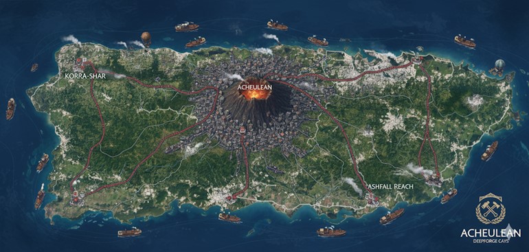
This national map of Acheulean depicts a large, verdant island continent characterized by a dominant, centrally located active volcano. The island is surrounded by a deep blue ocean teeming with the maritime trade that fuels the nation’s economy. The landscape is a mix of lush forests and open plains, with visible signs of civilization and industry integrated into the natural environment.
A complex network of major roads, rendered as distinct red pathways, originates from a massive central megacity built around the base of the volcano. These arteries of commerce and travel extend outwards to connect the industrial heartland with significant coastal cities, effectively dividing the island into several large administrative regions or states. The visual representation underscores a society that is highly organized, technologically capable with its steam-powered vessels and airships, and deeply connected to the formidable volcanic power at its core.
Major Cities
Acheulean (Capital Megacity of Sar-Kwe) Located at the geographic center of the island, the capital megacity is a sprawling urban expanse built in concentric circles around the base of the Great Fire Mountain. While the official name of the capital is Sar-Kwe, it is often referred to simply as Acheulean, as it is the undisputed heart of the nation. The city is a marvel of megalithic engineering, with structures carved directly into the volcano’s slopes and reinforced with dark metal and glowing Va-Shar runes. The air hums with the constant thrum of steam engines and industrial forges. Sar-Kwe serves as the seat of the matrilineal monarchy, the center of governance, and the primary hub for the nation’s economic and military power. The Grand Emberforge, the most sacred temple to the deity Korrath, is situated here, drawing immense power from the volcanic ley lines. All major roads originate from Sar-Kwe, cementing its role as the nexus of all national travel and trade.
Korra-Shar Situated on the rugged northwestern coast, Korra-Shar is a major port city and industrial center. Its name, translating roughly to “Korrath’s Blade” or “Korrath’s Edge,” reflects its strategic importance as a naval base and a primary point of export for Acheulean’s renowned metalwork and weaponry. The city is built into the dark basalt cliffs overlooking the ocean, with massive steam-powered lifts and cranes moving goods from the city’s workshops down to the bustling docks. Korra-Shar is known for its skilled shipwrights, who construct the nation’s formidable fleet of steamships, and for its specialized forges that produce the high-quality alchemical firearms and steam constructs traded across the world of Saṃsāra.
Ashfall Reach Located on the southeastern coast, Ashfall Reach is a city steeped in history and solemn purpose. It is built near the site of the ancient city of Valthar, which was destroyed in the legendary Ashfall. This historical weight shapes the city’s character; it is both a thriving commercial port and a place of remembrance. The architecture incorporates fragments of cooled lava and polished ash-glass from the historical eruption. Ashfall Reach serves as a cautionary hub, where the teachings of Korrath on balance and the dangers of hubris are most keenly felt. It is a major center for trade in raw materials, particularly the unique obsidian and other volcanic minerals harvested from the surrounding lands, which bear the lingering magical resonance of the Ashfall.
Points of Interest
The Great Fire Mountain This active volcano dominates the center of the map and the heart of the nation. It is not merely a geological feature but the spiritual and magical core of Acheulean. The Kwe-Sar believe the volcano to be the greatest of Korrath’s forges, and its volcanic ley lines are the source of power for their pyromancy and steam-powered industry. Its constant, gentle plume of smoke is a reminder of the immense power a an ever-present symbol of the balance between creation and destruction.
The Road Network The major roads depicted are more than simple trade routes; they are feats of engineering, fortified and maintained by the state to ensure the swift movement of goods and armies. Paved with a mixture of crushed basalt and magically treated materials, they are built to withstand the island’s seismic activity. These roads also serve as the formal boundaries for the nation’s internal states, delineating territories and administrative responsibilities.
The Trade Fleets The waters surrounding Acheulean are filled with numerous steamships, representing the nation’s significant role in global commerce. These vessels, constructed in ports like Korra-Shar, transport raw materials and finished goods, including steam engines, metalwork, and alchemical firearms, to the other 72 island countries. The presence of these fleets signifies the nation’s self-sufficiency and economic might.
Airships and Zeppelins Visible in the skies are hot air balloons and larger airships. These represent a common mode of transport for passengers and high-value cargo, especially for traversing the island’s rugged interior. They are powered by a combination of steam and levitation magic, reflecting the seamless integration of magic and industry in Acheulean society. Racing events featuring these airships are popular and prestigious.
The Deepforge Cays The emblem in the map’s corner mentions the “Deepforge Cays.” This likely refers to a chain of smaller islands or a specific coastal region off the main island mass, possibly near Ashfall Reach. These cays could be home to specialized, semi-aquatic Emberforges that utilize tidal steam or underwater volcanic vents, representing a unique and geographically distinct aspect of Acheulean’s industrial and religious landscape.
This map of Acheulean, a dynamic and industrially advanced island nation, showcases a strategic integration of urban centers, trade networks, and natural resources, all shaped by its unique volcanic terrain. The detailed layout reflects the Kwe-Sar’s pragmatic culture and their deep connection to the land, utilizing its raw power for their steam-driven society.
Secondary Communities
Beyond the major cities, Acheulean is dotted with numerous secondary communities, each playing a vital role in the national infrastructure:
- Forge-Villages (e.g., Ember-Thane, Cinder-Hold): Clustered near smaller volcanic vents and along the major road networks, these villages are dedicated industrial hubs. They house specialized forges producing specific metals, alloys, or components for the larger factories in Sar-Kwe or Korra-Shar. Emberforges in these villages are smaller, known as Ash Hearths, serving both as places of worship and communal workshops. Their populations are primarily skilled artisans, miners, and Firetenders.
- Highland Enclaves (e.g., Sky-Claw Aeries, Cloud-Forge): Perched in the higher, more rugged mountainous regions, often accessible only by smaller roads, airship, or Griffon, these enclaves are home to communities that specialize in high-altitude mining or crafting with rare, magically resonant minerals found in the upper volcanic slopes. They also serve as strategic defensive outposts and waystations for airship travel.
- Savanna Settlements (e.g., Dust-Ward, Grass-Spire): Located in the vast grasslands to the east, these are primarily nomadic or semi-nomadic communities focused on managing megafauna herds for resources like hide, meat, and specialized monster parts. They use mobile Ash Hearths and are highly skilled in tracking and survival, often trading these unique resources for Acheulean’s metal goods and steam technology.
- Coastal Outposts (e.g., Tide-Smith, Salt-Anvil): Smaller fishing and harvesting villages found along the less-developed coastlines. They provide unique marine resources, such as specialized sea monsters, to the larger cities and often operate small-scale tidal steam generators for their local needs. They are crucial for coastal defense and early warning systems against oceanic threats.
Trade Routes
The intricate network of trade routes across Acheulean reflects a highly organized and efficient distribution system:
- Primary Road Network (Red Lines): These are the backbone of Acheulean’s internal commerce, radiating from Sar-Kwe and connecting all major cities and significant Forge-Villages. They are heavily fortified and patrolled, designed for high-volume transport of raw materials to industrial centers and finished goods outwards. Steam-powered cargo haulers and armored carriages are common sights. These roads are often built over stable geological formations, utilizing Kwe-Va chants for structural reinforcement against seismic activity.
- Secondary Roads (Thinner, Lighter Paths): Branching off the main arteries, these roads connect the smaller Highland Enclaves and some Savanna Settlements to the primary network. While less fortified, they are still maintained and crucial for bringing specialized resources from remote areas to the larger markets. Travel on these roads is often slower, with smaller steam-wagons or pack animals being common.
- Naval Trade Routes (Depicted by Steamships): Acheulean maintains a dominant maritime presence. Trade routes extend from Korra-Shar and Ashfall Reach to other island nations within Saṃsāra, as well as along Acheulean’s own coastline. Steamships transport heavy industrial exports like engines, metal ingots, and alchemical firearms, and return with exotic goods, food, and resources not native to Acheulean. Coastal outposts serve as vital resupply points.
- Aerial Trade Routes (Depicted by Airships/Balloons): For rapid transport of high-value or time-sensitive goods, airships and hot air balloons utilize established aerial corridors. These routes often connect directly between major city-states or Highland Enclaves, bypassing arduous ground travel over rugged terrain. They are also essential for surveying uncharted smaller islands that frequently appear and disappear.
Natural Resource Zones
Acheulean’s landscape is rich in the resources vital for its unique industrial and magical economy:
- Volcanic Belt (Western and Central Regions): This dominant feature is a massive source of geothermal energy, powering steam engines and forges. It yields rich deposits of obsidian, basalt, and rare mineral ores, often infused with magical properties due to their proximity to ley lines. Specific areas are renowned for deposits of heat-resistant metals and crystalline structures used in magical gear.
- Deep Mineral-Rich Cave Systems: Beneath the mountainous regions, these extensive cave networks are mined for valuable metals, gems, and unique subterranean monster parts. Lithic Resonance is crucial for Kwe-Sar miners navigating these complex, often unstable, environments. Megacities also exist within some of these cave systems, leveraging the natural fortifications and resources.
- Eastern Savannas: These vast grasslands are home to specialized megafauna, providing hides, bones, and other biological materials. Medicinal herbs and fire-resistant timber are also harvested here. Nomadic Kwe-Sar communities manage these resources, employing ancient tracking skills and specialized steam-powered vehicles for harvesting and transport.
- Coastal Waters: The surrounding ocean provides a diverse range of marine life, including unique monster species whose parts are valuable alchemical ingredients or components for steam constructs. Coastal communities specialize in fishing and the harvesting of magical corals and sea minerals.
- Magical Ley Lines: While not a visible “zone” on the map, the entire island is permeated by these powerful conduits of magical energy, which are particularly strong around the volcano and within mineral-rich geological formations. These lines are meticulously mapped and channeled by Firetenders to power Emberforges, magical defenses, and industry.
Additional Terrain Information
- Basalt Cliffs and Plateaus: The coastlines and western regions are characterized by towering basalt cliffs and elevated plateaus, creating natural defenses and challenging terrain for land-based travel. These formations are often integrated into Kwe-Sar architecture.
- Obsidian Fields: Vast stretches of cooled lava form glittering black obsidian fields, particularly around the central volcano. These areas are sacred and serve as primary sources for the Kwe-Sar’s living bodies and for crafting their tools and weapons.
- Geothermal Vents and Hot Springs: Steam vents are a common sight, releasing plumes of vapor into the air. These are not only harnessed for industrial power but are also considered sacred sites, used for rituals of purification and tempering. Hot springs offer respite and natural warmth in the otherwise rugged environment.
- Fire-Resistant Flora: The vegetation across the island, particularly in the savannas and lower volcanic slopes, has adapted to the frequent seismic and volcanic activity, featuring hardy, fire-resistant trees and resilient grasslands.
- Dynamic Island Edges: Consistent with the broader Saṃsāra lore, the map implies areas where smaller islands might appear or disappear, particularly on the less-charted edges. This adds an element of unpredictable dynamism to the surrounding waters, encouraging exploration and vigilance.