
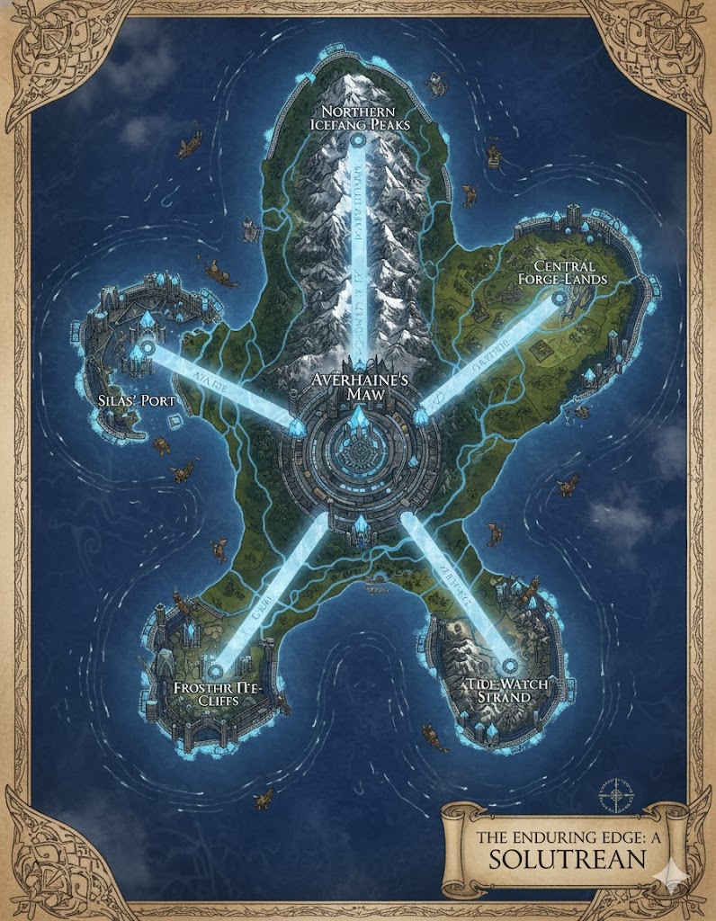
The national map of Solutrean depicts a sprawling, rugged island of approximately 300,000,000 acres. The geography is dominated by a central glacial massif that feeds the island’s primary waterways. The three Imperial Stone-Ways (major roads) radiate from the central capital, acting as the formal administrative borders between the nation’s three states.
The Three Administrative States
The major roads serve as the legal boundaries for the provinces:
- Vureas-North: The region between the North and East roads. This is the “State of the White Silence,” encompassing the northern tundra and high icefields where enchanted ice is harvested.
- Averhaine-Central: The region between the North and West roads. This province contains the temperate valleys, ancient stone quarries, and the bulk of the nation’s agricultural production.
- Edge-Coast (South): The vast region between the West and East roads. This state focuses on deep-water naval defense, maritime trade, and the crafting of long-range navigation gear.
Major Cities of Solutrean
1. The High Spire (Central Capital)
- Location: Built upon a massive granite pedestal at the island’s center, overlooking the source of the twin glacial rivers.
- Description: A fortress-city of obsidian and enchanted ice. It is the seat of the Thalmyric Queen and hosts the Stone-Ice Grand Sanctuary.
- Role: The administrative and spiritual heart. It serves as the primary “Memory-Lock,” holding the most sacred of the nation’s Tide-Scroll archives.
2. Port of the Fractured Shell (Western Anchor)
- Location: Built into the limestone cliffs of the western coast.
- Description: A city of “Vertical Harbors,” where sea-vessels are raised into cliffside docks using massive pulleys and water-shaping magic.
- Role: The primary gateway for trade with the island of Andean. It is the center of maritime law and the crafting of heavy naval tools.
3. Frost-Haven (Northern Anchor)
- Location: The northernmost city, situated on the edge of the permanent ice-shelf.
- Description: Constructed primarily of reinforced ice and whalebone, Frost-Haven is partially submerged to maintain temperature stability.
- Role: The center for Icecraft and the primary refinery for the “Enchanted Ice” used in Solutrean architecture across the nation.
4. The Iron-Shore (Eastern Anchor)
- Location: Located on the rugged eastern coast, where the mountains meet a high-energy sea.
- Description: Known for its volcanic basalt architecture and massive seawalls. The city is defined by the sound of rhythmic hammer-strikes from its toolmaking guilds.
- Role: The industrial hub of Solutrean, specializing in the forging of high-durability stone-working tools and naval hardware.
Points of Interest and Commerce
- The Twin Glacial Veins (Major Rivers): These rivers flow from the central mountains to the eastern and western coasts. They are the primary corridors for Ice-Sled Barges—flat-bottomed vessels that use the cold river currents to transport raw stone and lumber to the ports.
- The Imperial Stone-Ways (Roads): Paved with interlocking stone slabs and inscribed with Kairuth runes for stability, these roads are designed to remain clear of snow even in the harshest winters. They are the lifeblood of terrestrial trade.
- The Pillar of Veyra-Tel: An ancient, 400-foot-tall natural ice pillar in the northern tundra. It is a site of pilgrimage where young Thalmyric go to witness the aurora, believed to be the “Breath of Averhaine.”
- The Great Stone Quarry: Located in the central valley, this massive excavation is where the “Soul-Granite” for the nation’s temples is harvested. It is treated as a sacred site of “Shaping.”
- The Whispering Caverns: A network of flooded caves on the southern coast. Thalmyric scouts use these caves for “Vibration Training,” learning to detect distant ships through the resonance of the water.
This map illustrates a nation that has mastered the cold, turning a harsh environment into a perfectly shaped tool of survival and power. Every road and river is a calculated edge in the design of the Solutrean identity.
The geography of Solutrean is a testament to the “Enduring Edge,” where the 300,000,000 acres of land are carved into a functional masterpiece of ice, stone, and water. The terrain is not merely lived upon; it is “shaped” to serve the strategic and cultural needs of the 81 million inhabitants.
Secondary Communities: The Specialized Outposts
Beyond the four anchor megacities, the Solutrean landscape is dotted with Tier 2 and Tier 3 communities that act as the nation’s “support joints”:
- The Sledge-Towns (High Icefields): Located along the slopes of the central glacial massif. These are semi-nomadic communities of Thalmyric ice-harvesters who live in “Glow-Domes” made of translucent ice. They monitor the health of the glaciers and pre-carve the massive blocks of enchanted ice before they are sent down-river.
- Flint-Knapper Hamlets (Central Valleys): Small, industrious villages clustered around the ancient stone quarries. These communities are the heart of the nation’s toolmaking tradition, where even the children practice the “sacred strike” to create the razor-sharp blades used in Solutrean surgery and warfare.
- Grotto-Holds (Southern Cliffs): Submerged or semi-flooded communities built into the limestone sea caves of the south. These serve as the primary residence for the Thalmyric Navy families, allowing them to remain in constant contact with the “bone-resonance” of the ocean.
- The Peat-Vigil Outposts (Northern Tundra): Isolated clusters of stone huts where “Fuel-Keepers” harvest the rare, magically-enriched peat from beneath the permafrost. These outposts are vital for providing the heat necessary for the smithies in the Iron-Shore.
Trade Routes: The Logic of the Edge
Commerce in Solutrean follows the most efficient “cut” through the terrain, utilizing the Kairuth navigational principles:
- The Imperial Stone-Ways (The Fixed Veins): These prominent roads are the arteries of the nation. They are elevated above the snowline and kept clear by “Frost-Wick” enchantments that draw heat from the ground. Heavy llama-caravans and mechanical stone-drays move along these routes, transporting heavy ores and refined tools.
- The Glacial Sluices (The Flowing Veins): The twin rivers are engineered with “Ice-Locks.” During the summer thaw, Ice-Sled Barges use the high-velocity meltwater to transport bulk goods. In winter, the rivers freeze into “Glass Highways,” where wind-sailed sleds travel at immense speeds between the capital and the coast.
- The Tunnel-Paths: Beneath the central massif lies a network of geothermal tunnels. These are used primarily by elite messengers and the Thalmyric royalty to move across the island during the most violent seasonal snowstorms.
Natural Resource Zones: The Three Pillars
The monarchy partitions the island into zones based on the Path of the Shaped Ice philosophy:
- The “Clear-Cut” Forests (Temperate Center): Vast stands of cold-hardy timber. This wood is “stress-cured” by leaving it in glacial melt for a year, making it as strong as stone and ideal for the frames of Solutrean warships.
- The Blue-Vein Quarries: Deep pits in the central highlands that produce Soul-Granite. This stone vibrates when struck with a specific harmonic frequency, allowing it to be used in the construction of resonant “Voice-Towers” for long-distance communication.
- The Brine-Flats (Northwest): High-salinity coastal basins where salt is harvested not just for food, but as a stabilizing agent for the Enchanted Ice used in building.
Terrain and Geological Features
- The Massif of Averhaine: The central mountain range is a wall of obsidian and granite. It acts as a weather-shield, trapping the moisture of the sea winds to create the glacial rivers while keeping the central valleys temperate.
- The Razor-Shoals: Surrounding the southern coast are thousands of needle-like rock pillars. Only Thalmyric pilots using their “Dermal Vibration Sensing” can safely navigate these waters, making the southern ports virtually impregnable to foreign navies.
- The Aurora-Plateau: A high, flat expanse in the north where the magical “Curtain of Light” is strongest. This area is used for the Memory Trials, as the atmospheric mana here is said to make the Tide-Scroll glyphs glow with ancestral truths.
The map of Solutrean shows a nation that has rejected the chaos of nature. To a Solutrean, a mountain is a block of stone waiting for a chisel, and a river is a blade waiting for a hilt.