
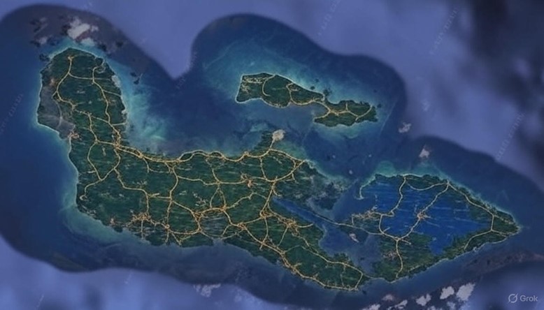
The map of the island nation of Hohokam depicts a sprawling archipelago with a central landmass flanked by smaller islands to the north and east, surrounded by deep blue waters that transition to turquoise near the shores. The terrain varies across the island, featuring dense green forests, arid desert plateaus, and marshy lowlands, with rugged mountains rising in the eastern uplands. A network of roads radiates from a central capital megacity located near the heart of the main island, connecting to major coastal cities. These major roads also serve as boundaries delineating at least three distinct states within the nation. Major rivers wind through the landscape, their courses marked by commerce activity along their banks, reflecting the island’s reliance on water for trade and sustenance.
The central capital megacity is a sprawling urban center with towering structures built from stone and turquoise-inlaid materials, its layout designed around a vast canal hub that feeds into the surrounding regions. The roads extending from this city are wide, paved with dust-road causeways, and lined with lantern-lit relay towers, facilitating travel and communication. Three prominent states are defined by these roads: the northern state, encompassing the arid plateaus and copper-green mountains; the eastern state, covering the marshy lowlands and crater lakes; and the southern state, dominated by river valleys and terraced cities.
Major rivers carve through the island, their waters managed by an intricate system of canals and spill-gates. Commerce thrives along these rivers, with bustling markets where goods such as maize, clay pottery, and turquoise artifacts are exchanged. Steam-powered barges and airships hover above, transporting trade items between cities, while hot air balloons and griffons add to the dynamic movement of commerce.
Major Cities and Information
- Kanathara (Central Capital Megacity)
- Location: Near the center of the main island, surrounded by a network of canals and terraced parks.
- Description: The political and cultural heart of Hohokam, Kanathara is a megacity with skyscrapers crafted from polished stone and horn, illuminated by magic-powered lanterns. The Royal Spill-Gate Registry resides here, overseeing water distribution, and the city hosts the grand Keystone Sanctum, a temple complex with massive bronze weirs and echo galleries.
- Population: Estimated at several million souls, including a significant population of Kokorut water-engineers and gate-sages.
- Significance: As the seat of the monarchy, it is the hub of trade, governance, and religious ritual, with markets bustling with goods from across the island.
- Aru-Kanath Port (Northern Coastal City)
- Location: On the northern coast of the main island, near the copper-green mountains.
- Description: A major port city built on stepped terraces overlooking the ocean, its harbor filled with steam-powered ships and airships. The city is renowned for its turquoise mines and artisan workshops that craft flow-staves and resonance chimes.
- Population: Approximately 1.2 million, with a mix of Kokorut builders and human traders.
- Significance: A key trade hub for exporting irrigation machinery and importing desert silks, it also hosts the Valley of Shattered Gates, a historical site tied to the myth of Aru-Kanath.
- Talutara Delta (Eastern Coastal City)
- Location: On the eastern coast, nestled among reed-choked marshes and crater lakes.
- Description: This city features floating platforms and underwater population centers, connected by canals that flow into the sea. Its architecture includes horn-counterweighted spill-gates and luminescent flow-robes worn by its inhabitants.
- Population: Around 900,000, predominantly water-monks and hydromancers of the Flow Gate Covenant.
- Significance: A spiritual center with multiple Keystone Sanctums, it is famous for festival immersions in sacred crater lakes and the production of ceramic wing-sleds.
- Sluicehaven (Southern Coastal City)
- Location: On the southern coast, adjacent to a wide river valley.
- Description: A terraced city with a bustling waterfront, Sluicehaven is known for its aqueduct skylines and steam-powered factories. The city’s markets are alive with the trade of maize and alchemical goods.
- Population: Approximately 1.5 million, including a large Kokorut population and multi-avatar households.
- Significance: A commercial powerhouse, it serves as a gateway for ships sailing the endless ocean and hosts racing events with hot air balloons and airships navigating labyrinthine courses.
Points of Interest
- Fifth Spillway: Located in the northern state near Aru-Kanath Port, this historical canal site is where Katu-ro, the Horn-Canal Wanderer, restored balance to the water flow. The spindle stone remains a pilgrimage site, its grooves still resonating with twin echoes, and it is adorned with offerings of obsidian-polished horns and song-sticks.
- Crater Lakes: Found in the eastern state near Talutara Delta, these sacred meteoric water bodies are used for festival immersions. The lakes are surrounded by collapsible diversion nets and are considered untouchable by the canal system, preserving their ritual purity.
- Kanath’s Shifting Spill-Gate: Situated in the central region near Kanathara, this ancient basin and gate bar, rediscovered by Aru-Kanath, is a symbol of the Flow Gate Covenant. Engineers listen for the heartbeat beneath the stone, and the site is marked by turquoise chips embedded in the gate structure.
- Eastern Uplands Copper Mines: Located in the northern state, these turquoise-veined mountains are a source of precious materials for Hohokam’s artisans. Monsoon storms carve temporary rivers here, which artisans net to support mining operations.
- Southern River Markets: Along the major rivers in the southern state near Sluicehaven, these vibrant commerce zones feature steam-powered barges unloading goods and Kokorut traders haggling with rhythmic precision in Sa hó tam. The markets are lined with dust-road causeways and lantern-lit stalls.
The map reflects Hohokam’s rich tapestry of geography, infrastructure, and culture, with its roads, rivers, and cities illustrating a society deeply intertwined with water management and magical industry.
The terrain of Hohokam unfolds across a diverse palette shaped by ancient geological forces and the ceaseless interplay of water and stone, where high desert plateaus rise like sun-baked shields in the north, their surfaces cracked into vast, wind-sculpted expanses that trap seasonal heat and release it in shimmering waves by midday. These plateaus give way to ribbon canyons that snake through the landscape, narrow fissures etched by flash floods that carve ochre walls veined with faint turquoise streaks, their depths echoing with the distant rumble of subterranean springs. Salt-fringed basins dot the interior, shallow depressions where evaporated floodwaters leave crystalline crusts that crunch under hoof or boot, and mirage fish—illusory glimmers born of refracted light—dance above the parched ground, luring unwary travelers toward illusory oases. To the east, copper-green mountains thrust upward in jagged spines, their slopes cloaked in sparse thornbrush and monsoon-fed gullies that swell into temporary rivers during storm seasons, the air thick with the metallic tang of exposed ore and the faint ozone hum of gathering clouds. Central river valleys form the verdant spine of the island, broad troughs where silt-laden waters from the uplands deposit fertile layers, supporting stepped terraces that climb from the floodplains like frozen waves, each level irrigated by feeder ditches that gleam with reflected sunlight. The western littoral stretches into reed-choked marshes, humid labyrinths of tangled fronds and brackish pools where the ocean’s breath mingles with inland flows, creating a perpetual mist that clings to the skin and muffles sounds into a soft, watery hush. Scattered throughout are uncharted smaller islands, some mere rocky outcrops emerging from the foam like the backs of submerged beasts, others verdant specks ringed by coral barriers that harbor bioluminescent kelp forests visible only at dusk.
Natural resource zones delineate the island’s wealth, each tied intrinsically to the terrain’s whims and the disciplined hand of canal stewardship. In the northern plateaus and canyons, copper and turquoise dominate, with veins snaking through the mountains like frozen rivers of green and blue, mined by teams of Kokorut laborers who descend via rope ladders into shadowed adits, their horns etched with daily yield tallies. These zones yield not only raw ore for crafting flow-staves and resonance chimes but also ochre clay from basin floors, prized for its plasticity in molding canal bricks that withstand seasonal heaving. Eastern marshes and crater lakes cradle unique botanicals, wild lily tubers and humidity-loving reeds harvested from the shallows, their fibrous stalks woven into collapsible diversion nets or distilled into alchemical essences that enhance hydromantic chants. The lakes themselves, fed by meteoric falls, accumulate rare mineral salts that precipitate as iridescent crusts, collected during low-water festivals for use in polishing horn crests or infusing cooling sashes. Southern river valleys bloom with agricultural bounty, maize fields terraced along the waterways in geometric precision, their golden stalks swaying under steam-pulse irrigation that draws from elemental fire and water to generate environmentally friendly vapor flows. Here, quarry faces expose limestone aggregates for public works, while hidden jungle fringes harbor forgotten timber groves, their hardwoods felled sparingly for aqueduct arches and zeppelin frames. Western littorals teem with maritime yields, salt pans evaporated from tidal creeks producing mineral blocks for trade, alongside reed beds that supply thatching for low-roofed marsh dwellings and fibrous cords for pulley systems in mechanical power transmission.
Secondary communities cluster in the interstices of this terrain, smaller settlements that pulse with the rhythm of local flows and serve as vital nodes in the nation’s water tapestry. In the northern plateaus, the outpost of Dustveil Hamlet perches on a canyon rim, a cluster of adobe hovels reinforced with horn keystones, where mason-mages apprentice in etching lineage scrolls onto salvaged canal tiles; its inhabitants, mostly tier-1 artisans, maintain relay towers that blink lantern signals across the arid expanse, guiding nomad caravans through salt basins. Further east along the mountain flanks lies Echo Basin Village, nestled in a veined hollow where copper dust colors the air, home to a guild of surveyor families who chart monsoon gullies with resonance staves, their roundwork lecture courts ringing with the recitation of gradient formulae under starlit skies. In the central valleys, Terraceford is a linear sprawl along a feeder ditch, its reed-mat homes elevated on stilts to evade minor floods, populated by multi-avatar households that blend Isekai souls from distant realms into communal labor rotations, their markets doubling as subtle hydromancy hubs where haggling rhythms settle silt in nearby plots. The eastern marshes host Reedwhisper Enclave, a floating assemblage of lashed platforms anchored by spill-gate chains, where water-monks of the Flow Gate Covenant conduct dawn algae scrapings and train initiates in twin-tone resonance, the air alive with the hollow notes of flow-staves summoning inspection crews from hidden galleries. Southern river bends shelter Maizegate Thorp, a fortified hamlet of terraced parks and dust-road causeways, guarded by Kokorut sentries in luminous cooling sashes, its youth memorizing district gradients while elders oversee steam-powered threshers that process harvests into export bales. On the western littoral, Saltfringe Hamlet emerges from the reeds like a half-submerged mosaic, its turquoise-pigment banners fluttering above courtyard gates, where clay-breath artisans inscribe Canalis Script on waxed bark scrolls, trading in evaporated salts for imported maize-star dyes.
Trade routes weave through this mosaic, binding communities in a web of measured exchange that mirrors the canal lattice itself. Major roads, those wide causeways of compacted earth and stone radiating from Kanathara, form the skeletal framework, their surfaces rutted by wagon trains hauled by steam-geared oxen or levitation-magic airships that skim low over the plateaus, laden with turquoise ingots bound for coastal forges. These roads double as state boundaries, the northern artery—flanked by copper-green sentinels—separating the arid uplands from central valleys, while the eastern thoroughfare threads through marsh mists to delineate lowlands from terraced heartlands, and the southern spine hugs river curves to partition floodplains from littoral fringes. Secondary paths branch off like feeder ditches, narrower trails of packed talus that wind through ribbon canyons, patrolled by hoof-anchored Kokorut guards who detect humidity shifts to preempt rockslides; these connect Dustveil Hamlet to Aru-Kanath Port, ferrying ochre clay in reed-wrapped bundles via griffon-back relays that soar over basin mirages. Riverine trade pulses along the major waterways, where steam-barges—propelled by magic-combined elemental flows—glide downstream from Terraceford’s granaries to Sluicehaven’s waterfronts, their decks stacked with maize sacks and ceramic wing-sleds, while upstream polers navigate against the current using horn-echo faults to trigger controlled cascades from canyon walls. Maritime lanes skirt the coasts, zeppelins and hot air balloons tracing the turquoise shallows to link Talutara Delta’s floating platforms with Reedwhisper Enclave, exchanging lily tubers for marsh salts in mid-air transfers that draw crowds for their daring precision. Overland balloon races carve ephemeral routes through southern labyrinths, days-long spectacles where competitors roar through terraced gaps, wagering electrum on whose wind-levitated craft first crests the valley rims, inadvertently scouting new branchways for settlement quests. Nomad caravans, resentful of water tariffs yet essential to the flow, traverse uncharted margins with collapsible net-carts, bartering frontier lore—tales of appearing islands rich in unmined turquoise—for tax reductions, their paths skirting the eastern uplands where monsoon nets capture storm runoff for resale as sacred immersion vials.
Beyond these, the terrain harbors subtler features that infuse daily life with quiet wonder and peril. Crater lakes in the east, untouched by canal diversions, shimmer with unmixing meteoric waters that glow faintly at equinox, drawing pilgrims for immersion rites where dew collects on dry stone as a manifest sign of Talutara’s favor. Ribbon canyons conceal forgotten ruins, vine-choked remnants of pre-soul-arrival civilizations with angular gate keys half-buried in silt, explored by tier-3 surveyors who draft contour diagrams by lantern light. Salt basins occasionally birth temporary salt-fringe blooms, fleeting meadows of crystal flowers that chime like flow-bells in the breeze, harvested for horn-polishing rituals before dissolving back to dust. Western marshes hide underwater population centers, bubble-domed habitats where pressure waves from Sa hó tam chants open submerged locks, allowing reed divers to emerge with baskets of bioluminescent kelp used in luminescent flow-robes. In the southern valleys, terraced parks double as communal oases, their calibrated weirs pouring springwater jars during link-span inspections, fostering harmonic balance that manifests as hairline cracks sealing unassisted overnight. The northern plateaus’ relay towers, tall spires of horn and bronze, amplify twin echoes across link-spans, coordinating gate-sage releases from afar, their bases ringed by apprentice schools where pupils measure real flow rates in feeder ditches. Scattered uncharted isles flicker into existence offshore, some vanishing after a season, whispered to be Talutara’s tests for patient reclaimers who restore branchways to earn lifetime reprieves from rent taxes. Throughout, the terrain’s magic ebbs and flows like weather, thin-water resonances stirring in spoken Sa hó tam to thin silt or condense mist, ensuring that every furrow, every vein, every basin contributes to the pulse between drought and flood that defines Hohokam’s enduring creed.