
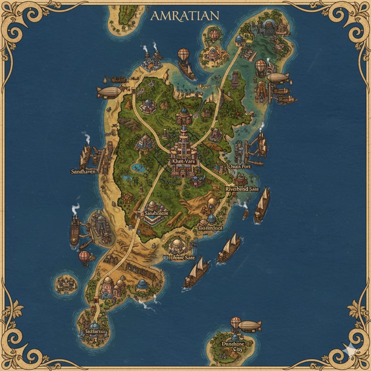
This national map of Amratian depicts a large, primary island continent with several smaller surrounding islands, all set within a vast ocean. The cartography is ornate, with a decorative border and a title banner at the top. The island’s geography showcases a distinct environmental duality. The central and northeastern regions are lush and green, dominated by the Great Khet River Valley. This fertile heartland gradually gives way to arid, golden deserts—the Serene Dunes—that comprise the western and southern parts of the continent.
A network of major paved roads originates from the central capital, Khet-Vara, branching out to connect the nation’s key cities. These roads serve as arteries for trade and travel and also form the political boundaries for the nation’s internal states. The map is detailed with illustrations of cities, airships, and seafaring vessels, indicating a technologically advanced society powered by steam and magic.
Major Cities
- Khet-Vara: The capital and heart of the Amratian nation, Khet-Vara is a sprawling megacity located in the center of the island, nestled within the fertile Great Khet River Valley. As the seat of the Matriarchal Monarchy, its architecture is dominated by immense, terraced ziggurats that serve as governmental palaces and administrative centers. The city is a vibrant hub of culture, where the traditions of the “River Folk” and “Sand Folk” intersect. It is the primary nexus for all major trade routes, with roads extending to every corner of the nation and its skies filled with hot air balloons, zeppelins, and airships.
- Sandhaven: Situated on the western coast, Sandhaven is a major industrial port city and a bastion of the “Sand Folk” culture. Its skyline is defined by large, steam-powered factories, shipyards, and drilling platforms that delve into the subterranean caverns. The city is a center for steamcraft and geomantic engineering, exporting sand-crafted goods and advanced steam-powered devices across Saṃsāra. Massive steamships are docked in its harbor, and airships are moored to tall towers, highlighting its importance in global trade.
- Oasis Fort: Located in the northeastern quadrant of the island, Oasis Fort is a strategic settlement built around a significant oasis. It serves as a military stronghold and a vital trade post connecting the northern territories. Its architecture is fortified, designed to protect the precious water source and the trade routes that pass through it. This city is a key center for the Sandwhisperers and those who traverse the Serene Dunes.
- Riverbend Sate: A large city built along a wide curve of the Great Khet River, southeast of the capital. It is a primary agricultural center, home to the “River Folk” who cultivate the magically-infused silt deposited by the river’s floods. The city is characterized by open-air markets, sprawling plantations, and numerous docks for the river barges and trade ships that ply the inland waterways, transporting grain, textiles, and other goods.
- Sandhome: South of Khet-Vara, at the edge of the Serene Dunes, lies Sandhome. This city serves as a major entrance to one of the vast subterranean networks where many of the “Sand Folk” live. The visible surface structures are large, dome-like buildings that are likely the tops of grand Sandshrines and access points to the cool, expansive city carved from the rock below. It is a major center for the faith of Amratianism.
- Raiderspool: Positioned on the eastern coast, Raiderspool is a bustling port with a more rugged character. Its name suggests a history of maritime conflict or a haven for privateers. It is a key commercial hub for sea trade, with numerous ships in its harbor. The city’s economy is likely driven by fishing, shipping, and the trade of goods from both the river valley and the nearby deserts.
- Itchme Sate: Located in the southern desert region, Itchme Sate is an important settlement that appears to be focused on resource extraction. Its unique name may derive from a local mineral or alchemical component found in the area. The city is connected by a major road and is likely a significant mining or alchemical production center, contributing to the nation’s industrial strength.
- Seatown: A prominent coastal city on the southern tip of the main island. Seatown is a major maritime port focused on ocean-going trade and fishing. Its strategic location makes it the primary point of departure for ships sailing to the southern islands, including Dunehone City, and beyond into the wider world.
- Dunehone City: This significant city is located on a large island off the southeastern coast of the mainland. Completely surrounded by the ocean and defined by its desert environment, Dunehone City is a remote but important cultural and spiritual center. It is likely a place for advanced sandcraft, a retreat for devout followers of Amratianism, and a self-reliant community that has mastered survival in its isolated, dune-covered landscape.
Points of Interest
- The Great Khet River: This massive river system is the lifeblood of the nation. It originates in the central highlands near Khet-Vara and flows outwards towards the eastern coast. The map shows heavy commercial traffic on the river, with numerous trade ships and barges, indicating its critical role in the Amratian economy for transporting agricultural goods from the fertile valley.
- Major Road Network: The roads are significant feats of engineering, cutting across diverse terrains from lush valleys to harsh deserts. They are the primary means of land-based transport for caravans and travelers, connecting the isolated desert communities with the populous river cities and coastal ports. As stated, these roads also serve as the demarcations for the nation’s states.
- Air Travel: The prevalence of hot air balloons, large zeppelins, and more advanced airships across the map signifies that air travel is a common and vital mode of transportation. These vessels are used for trade, travel, and military purposes, allowing for rapid movement across the vast and difficult landscapes of the island nation.
- Coastal and Island Settlements: In addition to the major cities, the map shows numerous smaller settlements along the coasts and on the smaller islands. These communities are likely focused on fishing, shipbuilding, and coastal defense, forming a protective and economic network around the main continent.
This map of Amratian offers a detailed view of its diverse terrain, ranging from lush river valleys to sprawling deserts, interspersed with industrial zones and ancient ruins. The primary island is a mosaic of biomes, reflecting the nation’s dual cultural identity. The Great Khet River dominates the central and northeastern regions, forming a vibrant, fertile corridor that stands in stark contrast to the vast, arid Serene Dunes extending across the west and south. The coastline is varied, featuring sheltered bays, rocky outcrops, and sandy beaches, indicating a rich maritime environment. The presence of smaller, uncharted islands further emphasizes the expansive nature of Saṃsāra’s oceans.
Secondary Communities
Beyond the major megacities and urban centers, several secondary communities contribute to the rich tapestry of Amratian life and economy:
- Dune-Edge Settlements (e.g., near Sandhaven and Sandhome): These smaller towns are positioned where the fertile river valley transitions into the desert or at the fringes of the deep dunes. They act as staging points for desert expeditions, small trading posts, and communities for specialized sand-miners or geomancers. Many of these would likely be subterranean extensions of surface dwellings, burrowing into the cooler earth.
- Oasis Villages (e.g., scattered across the Serene Dunes): Dotted throughout the arid regions, these villages are sustained by hidden magical aquifers and serve as crucial rest stops and water sources for travelers and trade caravans. They cultivate specialized desert crops, herd hardy beasts, and often host smaller Sandshrines for local worship.
- Riverine Hamlets (e.g., along the Great Khet River): Numerous small farming communities and fishing villages line the banks of the Great Khet River. These hamlets are characterized by simple mud-brick homes and extensive terraced fields, contributing significantly to Amratian’s agricultural output. They are interconnected by smaller tributaries and dirt paths leading to the main riverine cities.
- Coastal Outposts (e.g., along the varied coastline): Along Amratian’s extensive coastline, particularly on the less developed western and southern shores, are small fishing villages, lighthouses, and defensive garrisons. These outposts monitor maritime traffic, harvest sea resources, and provide essential services for the many ships sailing the endless ocean.
- Floating Platforms/Cities (e.g., offshore in various locations): While not explicitly drawn as megacities, the map’s context implies the existence of smaller floating platforms or nascent floating cities in strategic offshore locations. These could be specialized fishing hubs, naval patrols, or experimental airship docking stations, utilizing levitation magic to remain aloft.
Trade Routes
Amratian’s trade network is robust and multifaceted, reflecting its diverse environments and industries.
- Central Road Network: Radiating from Khet-Vara, the well-maintained major roads connect all significant inland and coastal cities. These are heavily trafficked by steam-powered land caravans, merchant wagons, and individual travelers, carrying manufactured goods, raw materials, and agricultural produce. The roads that delineate the state boundaries are particularly well-maintained due to their strategic importance.
- River Commerce: The Great Khet River serves as a major internal trade artery. Numerous barges, flat-bottomed boats, and smaller steam-powered vessels navigate its waters, transporting bulk goods such as grain, textiles, and building materials between Khet-Vara, Riverbend Sate, and other riverine communities before ultimately reaching the eastern coastal ports for wider distribution.
- Maritime Routes: The endless ocean surrounding Amratian is crisscrossed by established shipping lanes. Large steamships and sail-and-steam hybrid vessels transport goods between Amratian’s coastal cities (Sandhaven, Raiderspool, Seatown, Oasis Fort’s port) and other island nations of Saṃsāra. Exotic goods, metals, specialized monster parts, and alchemical ingredients are common imports, while Amratian exports include sand-crafted items, steam engines, agricultural surpluses, and unique alchemical potions. The smaller islands, like the one hosting Dunehone City, are connected to the mainland via these sea lanes.
- Aerial Routes: The skies above Amratian are busy with hot air balloons, zeppelins, and airships. These provide faster, albeit sometimes more expensive, transport for valuable cargo, dignitaries, and rapid communication between distant cities and even to other island nations. They often follow invisible magical currents or known wind patterns, bypassing challenging terrestrial terrain.
Natural Resource Zones
The map implicitly, and through lore, highlights several key natural resource zones crucial to Amratian’s self-sufficiency and industrial might:
- The Great Khet River Valley (Fertile Lands): This region is Amratian’s agricultural breadbasket. Its magically-infused silt, deposited by predictable floods, supports extensive farms, plantations, and orchards. Key resources here include staple crops (grains, fruits, vegetables), fiber plants (for textiles), and specialized herbs for Zaf-Khet magic and alchemy.
- The Serene Dunes (Sand and Minerals): The vast desert holds immense mineral wealth beneath its surface. Rich deposits of silica for glassmaking, various metallic ores (iron, copper, gold, silver), and unique magically resonant crystals are found here, primarily extracted through subterranean mining operations. The sand itself is a critical resource for sand-crafting, geomancy, and as a component in steam-powered filtration systems. Hidden oases also provide precious water sources, often with unique flora and fauna.
- Coastal Waters (Marine Resources): The seas around Amratian are abundant with marine life. Fishing fleets harvest a variety of fish, crustaceans, and other aquatic creatures for food and alchemical ingredients. Certain rare pearls or sea-borne magical reagents might also be found in deeper waters or specific coastal areas.
- Subterranean Aquifers (Water and Elemental Magic): Deep beneath both the river valley and the desert lie extensive magical aquifers. These not only feed the Great Khet River and the scattered oases but also serve as sources of elemental water for steam production. These aquifers are also potent ley line conduits, supplying the raw magical energy for geomancy and steam generation.
Additional Terrain Information
- Mountainous Spine (Central-North): The presence of the Great Khet River suggests an elevated source, implying a mountainous or hilly spine running through the central-northern part of the island. These highlands would be less populated but potentially rich in minerals and contain the headwaters of the river, perhaps dotted with smaller settlements or secluded Sandshrines.
- Rocky Coastlines: While some parts of the coast are sandy, there are likely stretches of rugged, rocky shores, particularly where the land meets deeper ocean currents. These areas might host natural sea caves, some of which could be inhabited or used for smuggling.
- Hidden Oases and Caves: Beyond the explicitly drawn cities, the desert is riddled with countless smaller, hidden oases and extensive cave systems. These are not only sources of water and shelter but also contain ancient ruins, forgotten lore, and unique monstrous ecosystems that have evolved within these secluded environments. Many of these caves are likely interconnected with the subterranean cities.
- Dense Jungles/Forests (North and East): While the river valley is fertile, the map also implies areas of denser, magically-fed jungles or forests, particularly in the northern and eastern regions that receive more rainfall or are fed by numerous smaller streams. These areas would be home to unique flora and fauna, and potentially forgotten ruins from older civilizations, as mentioned in the lore.
- Floating Islands/Platforms: The lore mentions floating cities. While not explicitly drawn as such on this national map (which focuses on landmasses), it is plausible that smaller, specialized floating platforms or temporary aerial settlements exist, leveraging levitation magic. These could be nomadic trade hubs or specialized magical research stations.
This expanded view of Amratian paints a picture of a dynamic, self-sufficient, and magically vibrant nation, intricately woven into its unique and challenging environment.