
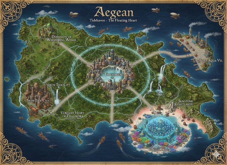
This national map of Aegean depicts a large, verdant island continent set within a vast ocean, rendered in a detailed, photorealistic fantasy style. The map is framed with an ornate, golden border and titled in elegant script. The geography is diverse, featuring lush forests, rolling hills, mountain ranges, and sandy coastlines. The overall aesthetic combines natural beauty with a magical, steampunk-industrial feel, evidenced by the presence of levitating structures, airships, and steam-powered vessels. Major roads radiate from a central capital, dividing the nation into distinct regions and connecting to other significant urban centers.
Major Cities
- Tidehaven – The Floating Heart: Dominating the center of the map is the capital megacity of Tidehaven. It is a breathtaking feat of magic and engineering, a massive city built upon a levitating island that floats within a shimmering, turquoise ring of magical energy. The city itself is densely packed with tall, elegant spires and grand buildings, reflecting the Renaissance-era elegance of the Thal-Ae culture. This is the seat of the Apsaran monarchy and the location of the Grand Tidetower, the primary temple of Aegeanism. The roads connecting the capital to the rest of the nation begin at the edge of this magical ring, emphasizing its central and elevated importance.
- Port Aqua-Vel: Located on the easternmost peninsula, Port Aqua-Vel is Aegean’s premier coastal trading hub. The illustration shows a sprawling port with extensive docks, warehouses, and numerous steamships and sailing vessels, highlighting its critical role in the nation’s economy. The city’s architecture is built to withstand the sea, with sturdy stone structures and lighthouses guiding ships into the harbor. As a gateway for international trade, Port Aqua-Vel is a melting pot where avatars from across Saṃsāra’s 73 island nations might be found.
- Iron-Tide City: Situated on the western side of the island, Iron-Tide City is the industrial heartland of Aegean. The city is depicted with a more rugged, functional architecture, characterized by the presence of gears, steam vents, and metalwork. This is where the fusion of elemental fire and water magic is harnessed to create the steam that powers the nation’s industry, from its airships to its levitation-driven mills. The city is strategically located along a major river, allowing for the easy transport of raw materials and manufactured goods.
- Coralia Major: Off the southern coast, nestled in the Sunstone Coastlands, is the underwater metropolis of Coralia Major. The city is shown enclosed within a massive, translucent dome built amidst a vibrant coral reef. Bioluminescent light emanates from within, illuminating the fantastical structures grown from living coral. This city is a prime example of the unique Coral Metropolises mentioned in Aegean lore, a magically sustained environment where Apsarans and other aquatic-adapted avatars thrive. It represents the nation’s mastery over the sea and its deep connection to Thalindra’s domain.
Points of Interest and Regions
The major roads serve as the boundaries for the nation’s primary states or provinces:
- Dominion of Whispering Winds: This lush, green region makes up the northern part of the island. It is characterized by rolling hills and dense forests, with several airships and zeppelins visible in the sky. This area is likely the center of Aegean’s aeromantic practices and air travel, home to griffon eyries and the shipyards that construct the nation’s majestic air fleets.
- Verdant Heart of Thalindra: Encompassing the vast southwestern jungle, this region is the wildest and most untamed part of Aegean. The map shows dense forests and waterfalls cascading from cliffs, consistent with the lore of inland jungles teeming with magical beasts and forgotten ruins. This area would be a place of high adventure, where avatars might explore ancient mysteries or test their skills against Saṃsāra’s unique monsters.
- Sunstone Coastlands: The southeastern portion of the island is known as the Sunstone Coastlands. It features beautiful pink and white sand beaches, clear turquoise waters, and a more arid, sunny climate. This region is a center for fishing, coastal trade, and is home to the underwater city of Coralia Major. Its picturesque shores are dotted with smaller Tidetowers and fishing villages.
- Rivers and Commerce: Several major rivers flow from the island’s interior to the sea, serving as vital arteries for trade and travel. The map depicts numerous ships navigating these waterways, transporting goods between the industrial Iron-Tide City, the agricultural heartlands, and the coastal ports, demonstrating a vibrant and active internal economy.
Terrain and Natural Resources
Beyond the major regions, the terrain of Aegean is rich with specific features and valuable resources that fuel its magical and industrial economy.
- The Ironback Range: West of Tidehaven, this rugged mountain range is the primary source of the nation’s mineral wealth. The foothills around Orestone Quarry are rich in iron, copper, and silver, which are transported downriver to the foundries of Iron-Tide City. Deeper within the mountains, veins of rare magical alloys like Orichalcum and Mithral are sought by master smiths for crafting high-tier gear.
- The Whispering Woods: The vast forests of the northern Dominion are known as the Whispering Woods. They are a crucial source of Luminwood, a magically resonant timber that is both lightweight and incredibly strong, making it ideal for the construction of airship frames and the hulls of enchanted sea vessels.
- The Great Falls of Thalindra: The massive waterfalls that cascade from the cliffs of the Verdant Heart are a major geographical landmark and a site of immense natural power. The mists here are perpetually charged with raw water and wind magic, making it a sacred place for Wavekeepers. The jungle basin below is a treasure trove of alchemical flora, yielding rare reagents for potions and enchantments.
- The Sunstone Shallows: The vibrant coral reefs and clear waters of the southeastern coast are known as the Sunstone Shallows. This zone is the exclusive source of Aura Pearls and living Sun-Coral, both of which are powerful conduits for hydromantic magic and are highly prized exports.
- The Sky-Kraken Deeps: The dark, deep waters off the northeastern coast are a notorious hazard zone. This area is known as the Sky-Kraken Deeps, a place where massive sea monsters and the dreaded sky-kraken are known to hunt, making both sea and low-altitude air travel exceptionally dangerous and requiring skilled naval escorts.
Secondary Communities
While the major cities dominate the landscape, a network of smaller towns and settlements forms the backbone of the nation.
- Aeridor Perch: Nestled high in the cliffs of the northern Wind-Shear Peaks, Aeridor Perch is a bustling town dedicated to air travel. Its platforms and magically-carved hangars service the nation’s griffon riders and zeppelin crews. It’s a key stop for lumber transport from the Whispering Woods and a training ground for the elite Aegean Sky-Guard.
- Mistfall Sanctuary: Located in a secluded basin near the Great Falls of Thalindra, this settlement is less a town and more a monastic sanctuary. It is home to an enclave of Wavekeepers, alchemists, and lore masters who study the potent magic and unique ecosystem of the Verdant Heart. It is a place of serene wisdom and a vital source of powerful alchemical recipes.
- Pearlwater: A picturesque town on the Sunstone Coast, Pearlwater is famous for its idyllic pink-sand beaches and its pearl-diving industry. It serves as a luxury resort destination for wealthy merchants and a primary supplier of food and goods to the nearby underwater city of Coralia Major, with which it shares a deep cultural bond.
- Orestone Quarry: This hardy mining town in the foothills of the Ironback Range is the starting point for much of Aegean’s industrial might. Its residents work the rich veins of the mountains, sending a constant stream of raw ore down the river to be forged into the steam engines and alloy plates that define Iron-Tide City.
Major Trade Routes
The lifeblood of Aegean flows along its well-established trade routes, which connect its cities and resources by land, sea, and air.
- The Saltwind Road (Land): This is the primary land route connecting the capital, Tidehaven, to the bustling port of Port Aqua-Vel. Heavily patrolled and well-maintained, this road sees constant traffic from merchant caravans carrying finished goods, imported luxuries, and food supplies.
- The Cog & Steam Trail (Land): This rugged western road connects Tidehaven to Iron-Tide City. It is primarily used for transporting refined metals, complex machinery, and steam-powered components from the industrial heartland to the capital and other markets.
- The Coastal Current (Sea): The most trafficked sea lane is a coastal route that links Port Aqua-Vel, the town of Pearlwater, and the river deltas of the west. Fleets of steamships and merchant vessels constantly ply these waters, trading everything from raw minerals and lumber to pearls and textiles.
- The Sky-Tide Zephyr (Air): This is the premier air route for high-speed travel and the transport of high-value, low-weight cargo. It forms a triangle connecting Tidehaven, Aeridor Perch, and Port Aqua-Vel. Travel is by luxury zeppelin or swift-glider, offering a breathtaking but expensive way to traverse the nation above the dangers of the land and sea.