
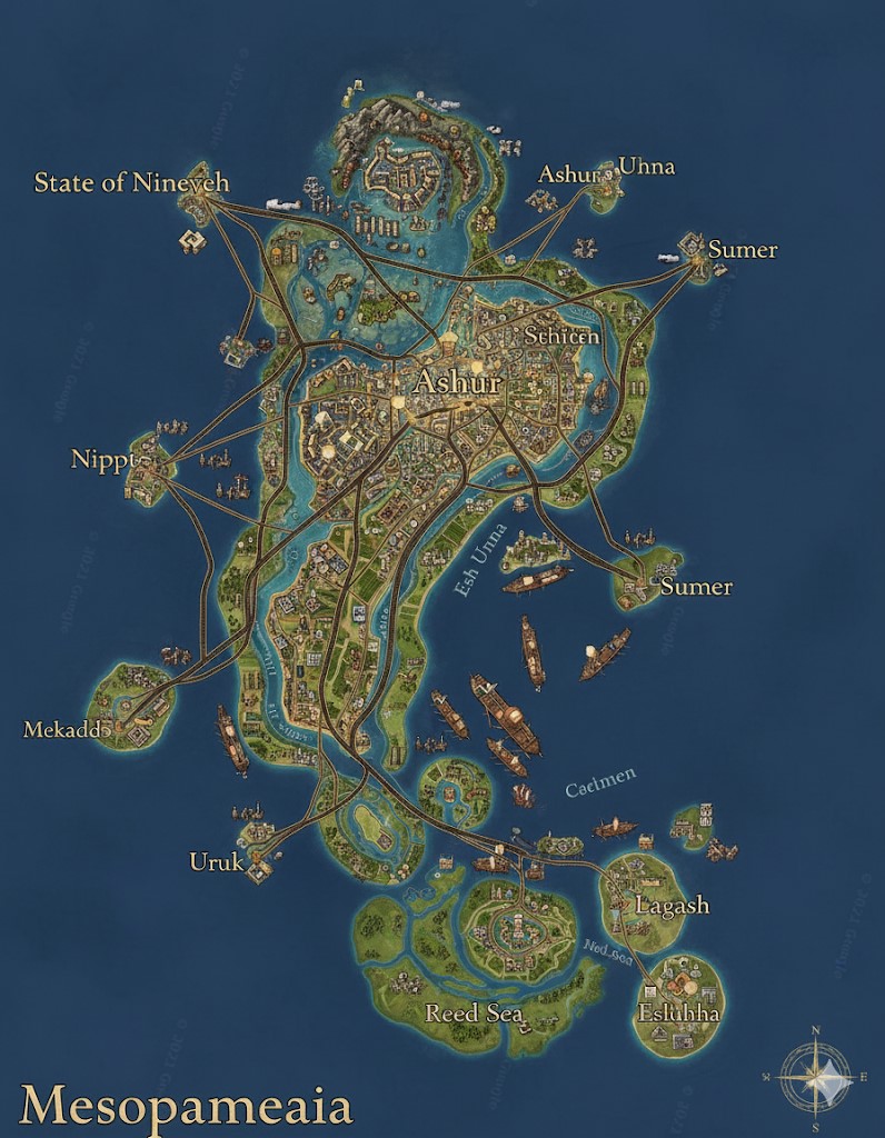
This is a national map of the island nation of Mesopotamia, a continent characterized by its vast, fertile river valleys and bustling, orderly civilization. The map showcases a land shaped by two great rivers, a network of advanced infrastructure, and a society built on the principles of law and commerce.
Geographic and Political Overview
The continent is dominated by the courses of its two great life-giving rivers, the Esh and the Unna. These rivers flow from the north, converging in the southern part of the island to form a massive freshwater marshland known as the Reed Sea before meeting the ocean. The land is incredibly fertile, crisscrossed by a meticulous and extensive network of canals that support widespread agriculture.
The nation is politically divided into several states, with major roads serving as the boundaries. From the central capital of Ashur, three great highways radiate outwards, defining the borders of the State of Nineveh to the northwest, the State of Uruk to the southwest, and the State of Sumer to the east. These roads are feats of engineering, forming the primary arteries for trade and travel across the continent. The waterways are equally vital, with the map depicting heavy commercial traffic of steam-powered vessels and barges, indicating that the rivers are the lifeblood of Mesopotamian commerce.
Major Cities
The map highlights several major urban centers, each with a distinct role within the nation’s structure.
- Ashur (The Capital Megacity): Located at the heart of the nation and the confluence of its major road and river networks, Ashur is the administrative, legal, and commercial core of Mesopotamia. As a sprawling megacity, it is home to the Scribe-Queen’s ziggurat palace, the highest courts of the Measured Path, the Grand Library, and the central guilds for scribes, architects, and merchants. Its position ensures it controls the flow of goods, information, and law throughout the entire nation.
- Nineveh: The capital of the northwestern state that bears its name. Situated near the Northern Uplands, Nineveh is a vital industrial and administrative hub. It likely processes the stone and metal extracted from the nearby mountains, feeding the nation’s workshops and construction projects. It serves as a major gateway for overland trade and controls access to the northern territories.
- Sumer: A major eastern coastal city and the primary port for the State of Sumer. It is a bustling center of maritime trade, its harbors filled with ships from across the world of Saṃsāra. Sumer is the main point of export for the agricultural bounty of the eastern river valley and the finely crafted goods produced in the nation’s interior.
- Nippur: A significant western port city. Nippur acts as the primary maritime gateway for the western river valley. It is a center for trade and likely houses a large naval presence to protect Mesopotamian shipping interests. Its markets are known for their exotic goods brought in by sea.
- Mekadd: A southwestern coastal city located on the road between Nippur and Uruk. Mekadd serves as another key port, likely specializing in the export of agricultural products from the rich Clay Plains and facilitating trade along the western coast.
- Uruk: The capital of the southwestern State of Uruk. It is a large and influential city that governs the fertile lands of the south. Uruk is a center for education and law, second only to Ashur, and is a critical hub for managing the vast agricultural output of the southern plains before it is shipped out via the coastal ports.
- Lagash: Located within the marshy delta of the Reed Sea, Lagash is a unique city whose economy is built around the resources of the massive swamp. It is the primary producer of reeds used for papermaking and construction, and its people are masters of navigating the intricate waterways of the delta.
- Eridu: The southernmost port city on the map, situated on the edge of the Reed Sea where it meets the ocean. Eridu is a vital center for fishing and pearl diving, and it serves as the primary trade link with any southern island nations or uncharted territories.
Points of Interest
- The Twin Rivers (Esh and Unna): These are the foundational elements of the nation. The map shows them as wide, navigable arteries teeming with steamships and barges, underscoring their importance not just for irrigation but as the primary highways for heavy commerce.
- The Reed Sea: A vast freshwater marshland in the south. This unique environment is a critical natural resource, providing the raw materials for papyrus (the medium for the ‘Shur-Unna’ script) and building materials for lighter structures. It is a region of immense biological diversity and home to communities who have adapted to a life on the water.
- The Great Highways: The three major roads originating from Ashur. They are depicted as prominent, well-maintained thoroughfares, suggesting a high level of engineering and a society that values efficient, orderly transportation. They are more than just roads; they are symbols of the central government’s reach and the unifying structure of its law.
- Canal Network: While the major rivers are prominent, a closer look reveals a dense, grid-like pattern of smaller waterways, especially in the fertile valleys. This is the continent-spanning canal and irrigation system mentioned in the lore, a testament to the Mesopotamians’ ability to impose order upon nature to create predictable prosperity.
Terrain and Natural Resource Zones
The nation of Mesopotamia can be divided into distinct geographic zones, each providing critical resources that fuel the civilization’s orderly existence.
- The Northern Uplands: Encompassing the northern reaches of the State of Nineveh, this region’s terrain is characterized by dry, rocky hills and low mountains. This is the primary mining and quarrying district of the nation. The uplands are rich in high-quality stone for monumental construction and the copper and tin that, when alloyed, form the basis of their metalworking industry. The city of Nineveh acts as the administrative hub for these resource-extraction operations.
- The Twin River Valleys: This is the vast, fertile heartland of Mesopotamia. The terrain is exceptionally flat, composed of rich alluvial soil and clay deposited over millennia by the seasonal floods of the Esh and Unna rivers. This zone is the nation’s breadbasket, dedicated to the large-scale, organized cultivation of grain and other crops. The land is also a source of abundant clay, a resource as valuable as gold in this society. The finest clay is used for the sacred legal tablets of the Ki-Unna script, while the rest is mass-produced into the bricks that form their cities.
- The Reed Sea: The terrain of the southern delta is a massive freshwater marshland, a labyrinth of shallow waterways, reed beds, and small, marshy islands. This region’s most vital resource is the towering reeds that grow in abundance. These are harvested and processed in cities like Lagash to create the papyrus used for the everyday Shur-Unna script, as well as materials for thatch, light construction, and boat-making. The marshes also support a thriving fishing industry and are home to unique flora and fauna used in alchemical preparations.
Secondary Communities
While the great cities dominate the map, the nation’s prosperity is built upon a foundation of countless smaller settlements.
- Farming Communes: The entirety of the Twin River Valleys is dotted with thousands of smaller, unnamed farming villages and communes. These settlements are meticulously planned, typically organized in grid patterns along the life-giving irrigation canals. They are the primary producers of the nation’s food surplus and are administered from the larger regional cities.
- River Waypoints: Situated along the banks of the Esh and Unna between the major cities are numerous smaller river towns. These settlements serve as crucial waypoints for the heavy barge traffic, functioning as local markets, repair depots for steam vessels, and ferry crossings for local travel.
- Mining and Quarry Outposts: The Northern Uplands are sparsely populated, but they host specialized and hardy communities dedicated to resource extraction. These outposts are rugged, functional settlements, often built directly into the hillsides, focused entirely on the mining of stone and ore which is then transported downriver.
- Coastal Fishing Hamlets: Sprinkled along the coastline, particularly between the major port cities and around the Reed Sea, are small fishing hamlets. These communities supply fresh and preserved fish to the nation’s markets and often act as the first line of coastal defense and observation.
Trade Routes and Commercial Flow
Trade in Mesopotamia is a highly organized and constant flow, mirroring the controlled flow of their rivers.
- Riverine Superhighways: The Esh and Unna rivers are the main arteries for the bulk transport of goods. A steady stream of steam-powered barges moves downriver, carrying heavy cargo like stone, metal ore, grain, and clay bricks from the resource zones to the major cities for processing and export. The upriver traffic consists of lighter, more valuable cargo: imported goods, refined metals, textiles, and official missives being distributed from the coastal ports and the capital.
- The Great Highways (Land Routes): The three major roads radiating from Ashur are used for high-speed and high-value transport. Large, steam-powered cargo haulers and swifter passenger vehicles travel these routes. They are primarily used to transport finished artisan goods, official personnel, legal documents (clay tablets), and military cohorts. Trade along these roads is faster but more expensive than river travel, reserved for goods where speed is paramount.
- Maritime Trade Routes: The coastal cities of Sumer, Nippur, Mekadd, and Eridu are the nation’s windows to the wider world of Saṃsāra. From these bustling ports, Mesopotamian ships export their greatest surpluses: vast quantities of grain, expertly crafted textiles, and their most unique product—magically-bound legal contracts crafted by the Scribe-priests for international corporations and other nations. In return, they import resources the island lacks, such as dense hardwoods, exotic spices, rare alchemical reagents, and specialized magical crystals required for their more advanced industries.
- The Canal Network (Local Commerce): This intricate web of smaller waterways functions as a local trade network. Small, shallow-draft barges and boats move goods on a micro-level, transporting produce from a specific farming commune to a nearby river town’s market, or moving raw clay from a riverside quarry to a local brickmaker. This network ensures that every part of the civilization is connected to the greater economic machine.