
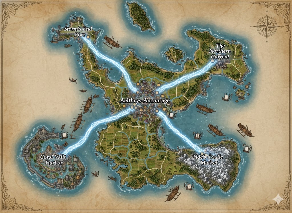
The national map of Stillbay illustrates a massive island territory of approximately 155,100,000 acres, where the land is sculpted into a series of protective curves and fortified bays. Radiating from the geographic center are the three Royal Currents (primary trade roads), which serve as the formal administrative boundaries for the nation’s three constituent states.
The Three Administrative States
The major roads act as the legal and geographic dividers of the realm:
- Aelth-Shade (North): The region between the Northern and Eastern Royal Currents. This state is defined by deep fog banks and forested highlands that provide the timber for the Royal Navy.
- Vhall-Rise (West): The region between the Northern and Western Royal Currents. This is the agricultural and academic heartland, containing the most prestigious Vhallic universities and terraced rice paddies.
- The Brine-Reach (South): The vast southern expanse between the Western and Eastern Royal Currents. It is a region of jagged reefs and volcanic ridges, serving as the nation’s primary source of obsidian and mineral wealth.
Major Cities of Stillbay
1. Oakhaven (The Central Capital)
- Location: Situated at the absolute center of the island, where the three Royal Currents converge at the mouth of the Great River.
- Description: Known as the “Anchor of the North,” this megacity is built in concentric rings resembling a giant nautilus shell. It houses the Stone of Many Echoes and the matrilineal royal palace.
- Role: The administrative hub and seat of the monarchy. All national taxation and land-leasing records are stored in the palace’s vault.
2. Port of the Silver Tide (Northern Anchor)
- Location: Built into a deep, crescent-shaped natural harbor on the northern coast.
- Description: A city characterized by “Glow-Docks” lined with bioluminescent coral. The architecture is designed to resist the heavy autumn storms.
- Role: The primary naval shipyard and the main port for exporting highland timber.
3. Shell-Watch (Western Anchor)
- Location: Located on the edge of the western lagoons, protected by a series of massive artificial tide-walls.
- Description: A city of elegant white stone and gem-inlaid bridges. It is the center of the Stillbay jewelry and luxury textile trade.
- Role: The cultural capital and center for the Tidebound Covenant’s high-ritual processions.
4. Reef-Fort (Eastern Anchor)
- Location: A fortified city built directly onto a volcanic basalt ridge overlooking the eastern reefs.
- Description: Rugged and practical, its buildings are carved directly into the dark rock. It features massive lantern-braziers that act as beacons for the fleet.
- Role: The industrial powerhouse and primary defensive bastion against eastern sea threats.
Points of Interest and Commerce
- The Vhallic Arteries (Major Rivers): Two massive rivers flow from the central highlands to the sea. These are the primary corridors for Shell-Barges—low-draft vessels that transport grains and obsidian. Commerce here is regulated by the “Water-Keepers,” who use Vhallic chants to synchronize barge traffic.
- The Royal Currents (Roads): These are not merely dirt paths but paved embankments of crushed shell and volcanic lime. They are wide enough for four heavy caravans to pass abreast and are lined with “Mercy-Shrines” dedicated to Aelthrys.
- The Bioluminescent Lagoons: Located near Shell-Watch, these waters contain unique lifeforms that glow according to the moon’s phases. This is a primary resource zone for alchemical ingredients.
- The Obsidian Ridge: A volcanic formation in the south where the nation’s rarest minerals are harvested. The “Shadow-Miners” here use specialized Ka’thirn breather masks to navigate the sulfurous vents.
- The Great Tide-Wall: A monumental engineering feat protecting the southwestern coast. It is etched with Talcarve runes that reinforce the stone against the crushing pressure of the sea.
This map portrays a nation that is “anchored” in its environment, using the natural curves of the island to create a society that is both a fortress and a work of art.
The geography of Stillbay is a masterwork of “Functional Elegance,” where the island’s 155,100,000 acres are carved into a strategic layout of shell-shaped harbors and terraced highlands. The terrain is defined by the Tidebound Covenant’s philosophy: the land is a vessel, and the people are its crew.
Secondary Communities: The Specialized Outposts
While the four megacities anchor the nation, the spaces between the Royal Currents are populated by vital Tier 2 and Tier 3 communities:
- The Silt-Step Villages (Vhall-Rise): Located along the banks of the western rivers, these communities manage the vast terraced rice paddies and freshwater oyster beds. They are known for their “Flood-Festivals,” where they use Vhallic paired half-tones to coordinate the opening of irrigation sluices.
- Whale-Bone Hamlets (Aelth-Shade Highlands): Clustered near the northern timberlines, these Ka’thirn outposts focus on “Stress-Curing” wood in high-altitude lagoons. Their architecture consists of stilted lodges built into the steep slopes, connected by intricate rope-bridge networks.
- Basalt-Hollows (The Brine-Reach): These are subterranean or cliff-face mining towns in the southern volcanic ridges. The inhabitants are experts in Coral-Crafting and extracting obsidian. These towns are unique for being largely nocturnal, with life revolving around the bioluminescent moss that grows in the mines.
- Lagoon-Watch Posts: Small, fortified towers situated on the outermost jagged reefs. They house Wave-Keepers who monitor the “bone-resonance” of the sea to provide early warning for incoming storms or hostile vessels.
Trade Routes: The Veins of Memory
Commerce in Stillbay flows through a highly regulated network that prioritizes both speed and ritual:
- The Royal Currents (Land): These primary roads are treated as sacred ground. Tolls collected here fund the “Memory-Anchoring” magic that prevents the shell-paved roads from eroding. Large Ka’thirn caravans use “Dray-Sleds” pulled by domesticated reef-beasts to move heavy minerals from the south to Oakhaven.
- The High-Tide Sluices (River): The major rivers act as liquid highways. During “Spring-Tides,” the water level rises enough for deep-draft merchants to reach the capital. Shell-Barges move in rhythmic “Vhallic Convoys,” where the lead captain sets a chant that synchronizes the rowing or sail-trimming of the entire fleet.
- The Cliff-Paths: Secondary routes that wind along the jagged coastal edges. These are narrow, dangerous paths used primarily by Ka’thirn messengers who utilize their short-burst leaping and climbing abilities to bypass longer road segments.
Natural Resource Zones: The Bounty of Aelthrys
The monarchy maintains strict control over these zones to ensure long-term stability:
- The Kelp-Forest Preserves: Massive underwater forests on the western coast. These are harvested for the fibers used in Stillbay’s shimmering fabrics and for medicinal sea-plants used in “Coastal Remedies” for joint stiffness.
- The Glass-Sand Flats: Located in the north, these beaches yield a specific type of silica used to create the “Frost-Crystals” embedded in Stillbay’s streetlamps and navigational beacons.
- The Obsidian Flutes: A section of the southern volcanic ridge where the wind blowing through hollow basalt tubes creates a constant musical hum. This obsidian is prized for its resonance and is used to forge the Ceremonial Armor of the Royal Guard.
Terrain and Geological Features
- The Spine of the Deep: A central mountain range that feeds the island’s rivers. It is a wall of dark basalt and granite that acts as a weather-break, ensuring the central capital of Oakhaven remains sheltered from the harshest oceanic winds.
- The Bioluminescent Shoals: A shallow shelf surrounding the southern coast. At night, the water here glows indigo and seafoam green, reflecting the colors of the Tidebound Covenant. This area is a natural defensive barrier, as the light reveals any vessel attempting a “silent” approach.
- The Whispering Estuaries: Where the Great River meets the sea near the capital. The interplay of saltwater and freshwater creates a constant mist, which the Ka’thirn orators use to project their voices further using Memory Resonance magic.
The map reveals a nation that does not fight the sea, but flows with it. Every secondary community and trade route is positioned to take advantage of the cycles of the moon, ensuring that Stillbay remains an unbroken kingdom of tide and stone.