
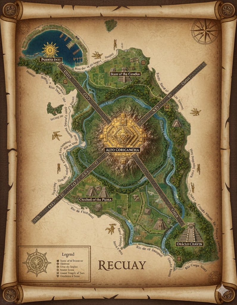
The national map of Recuay depicts a rugged, high-altitude island nation of approximately 480,000,000 acres. The geography is dominated by the Cajamarca Cordillera, a massive central mountain range that bisects the island. The civilization is defined by its verticality, with cities built into cliff faces and connected by a sophisticated network of Great Stone Ways.
The Three Administrative States
The major roads radiating from the center serve as the borders for the nation’s primary provinces:
- Chavín-North: The region between the North and West roads. It is characterized by high-altitude tundra (puna) and is the center of the nation’s spiritual stone-carving traditions.
- Yauyos-East: The area between the North and East roads. This state contains the most fertile “Sun-Valleys” and the primary agricultural terraces that feed the megacities.
- Wari-South: The vast region between the East and West roads, focusing on maritime trade, coastal fishing, and the defense of the southern archipelago.
Major Cities of Recuay
1. Pashash (The Central Capital)
- Location: Built directly into the highest peak of the central cordillera, overlooking the “Sacred Confluence” of the island’s three major rivers.
- Description: A vertical megacity of white granite and burnished copper. Houses are built in “honeycomb” clusters connected by hanging bridges and massive stone staircases.
- Role: The seat of the Recuay High Council. It is the center of governance and the location of the Great Obelisk, which acts as a focal point for the nation’s magical communication.
2. Port of Gallinazo (Western Anchor)
- Location: Situated on the edge of a sheer cliff dropping into the western ocean.
- Description: Known for its “Lift-Docks,” where goods are raised from sea level via massive water-powered pulleys. The city is famous for its ceramic export warehouses.
- Role: The primary gateway for trade with the island of Pueblo. It specializes in the export of high-altitude minerals and luxury medicinal herbs.
3. Vicús-on-Sea (Northern Anchor)
- Location: A coastal city built where the northern river creates a wide, sandy delta.
- Description: Unlike the mountain cities, Vicús features sprawling low-rise adobe architecture and vast “Sun-Courtyards” used for drying colorful textiles.
- Role: The center of the textile industry and gold-smithing. It is the wealthiest city per capita due to its proximity to the northern gold veins.
4. Salinar-Delta (Eastern Anchor)
- Location: Located at the mouth of the eastern river, surrounded by dense tropical mangroves.
- Description: A city built on stilts and stone pylons. It is the only major city with a significant “Water-Market” where commerce is conducted entirely via reed boats.
- Role: The hub for agricultural distribution and the primary shipyard for the Recuay fishing fleets.
Points of Interest and Commerce
- The Three Life-Veins (Major Rivers): These rivers originate from the glaciers surrounding Pashash. They are the primary corridors for Stone-Barges—heavy, magically-buoyant rafts that transport raw building materials and agricultural products from the high valleys to the coast.
- The Great Stone Ways (Roads): These are not merely paths but engineered feats of masonry. They are wide enough for four llama-drawn caravans to pass abreast and are lined with Tambos (rest houses) every ten miles.
- The Terraces of Wiracocha: A massive archaeological and agricultural zone in the eastern state. These stone-walled terraces climb over 2,000 feet up a single mountainside, producing the specialized “High-Mana Corn” used in religious rituals.
- The Singing Canyons: A natural geological feature in the south where the wind passing through basalt pillars creates haunting melodies. The Recuay believe these are the voices of ancestors and have built numerous small shrines within the caves.
- The Copper-Gate Bridge: A massive suspension bridge on the Western Road that spans a 500-foot deep chasm. It is a vital trade link and is considered one of the wonders of Saṃsāra’s engineering.
This map represents a nation that has conquered the vertical world, turning steep cliffs into homes and thin mountain air into a source of spiritual and economic power.
The national map of Recuay is a blueprint of vertical mastery, where the 480,000,000 acres of territory are managed through a series of “Ecological Tiers.” The civilization thrives by exploiting the specific resources found at different altitudes, connected by a logistical network that defies the rugged terrain.
Secondary Communities: The High-Altitude Outposts
While the “Anchors” manage the coast and the capital manages the state, smaller communities act as specialized organs of production:
- Puna-Hamlets: Located in the vast, treeless grasslands (puna) above 12,000 feet. These are populated by hereditary Llama-Pastors who manage the massive herds of pack animals required for the “Great Stone Ways.” These communities are built with thick, low-profile stone walls to withstand the piercing mountain winds.
- The Mining-Cliffs: Semi-subterranean towns built directly into the copper and silver veins of the Cajamarca Cordillera. These communities use water-powered “Crush-Mills” driven by glacial melt to process raw ore before it is sent to Pashash.
- The Saffron-Valleys: Small, secluded villages in the “Rain-Shadow” of the mountains. They specialize in the cultivation of rare, magically-conductive dyes and medicinal herbs that only grow in the thin air and intense ultraviolet light of the high peaks.
- Tambo-Stations: Though primarily rest stops, these have evolved into small trade hubs. They serve as “Neutral Markets” where coastal traders exchange salt and dried fish for the tubers and metalwork of the mountain dwellers.
Trade Routes: The Stone and the Sky
Commerce in Recuay is a constant cycle of ascent and descent, managed by two primary systems:
- The Great Stone Ways (The Terrestrial Veins): These are the prominent roads seen on the map. They are paved with interlocking granite slabs and utilize “Zig-Zag” switchbacks to climb the steepest slopes. Caravans of hundreds of llamas, each carrying roughly 60 lbs of goods, move in rhythmic lines between the coast and the capital.
- The Glacial Flumes (The Water-Ways): During the thaw season, the Recuay use the major rivers as high-speed chutes. Log-Rafts carrying heavy timber or stone blocks are guided downstream by “Current-Callers”—Tier 3 avatars who use minor hydro-magic to prevent the rafts from shattering against the canyon walls.
- The Bridge-Network: Because the terrain is riddled with deep chasms, the trade routes rely on Fiber-Suspension Bridges. These are considered sacred structures; the “Weaving of the Bridge” is a communal ritual performed annually to ensure the safety of the trade route.
Natural Resource Zones: The Vertical Treasury
The terrain is partitioned by altitude, with each zone providing a specific “Line Item” for the national ledger:
- The Glacial Cap (The Water Source): The peaks above 16,000 feet are the “Vaults of Life.” The Recuay protect these areas fiercely, as they provide the elemental water that powers the flumes and irrigates the lower terraces.
- The Copper Belt: A middle-altitude zone surrounding Pashash. This area is rich in malachite and azurite, providing the “Burnished Copper” that characterizes Recuay’s architecture and high-tier armor.
- The Maize-Steps: The eastern slopes of the range, where the humid air from the sea meets the mountains. This creates a “Cloud Forest” environment perfect for the stone-walled agricultural terraces that produce the nation’s caloric surplus.
Terrain and Geological Features
- The Razor-Ridges: The central mountain range features “Knife-Edge” ridges that provide natural defensive barriers between the three states. Only the Great Stone Ways provide passage through these walls.
- The Sun-Sinks: Large, circular depressions in the high plateau that act as natural “Heat-Traps.” The Recuay have converted these into amphitheaters and communal kiva-like spaces for spiritual gatherings.
- The Mangrove-Fringe: The eastern coast is a maze of saltwater forests. This provides the “Flexible Wood” used for the scaffolding and bridge-frames that support the vertical stone cities.
The map of Recuay illustrates a nation that does not see mountains as obstacles, but as the very foundation of their wealth. Every cliff is a potential home, and every river is a potential highway.