
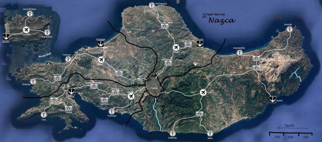
Based on the map of the Island Nation of Nazca, here is a detailed analysis of its geography, political structure, and infrastructure for future reference:
1. Political and State Boundaries
The map is divided into four distinct administrative states defined by prominent black boundary lines that intersect at the central capital. These states are situated around the central hub of Tiame.
- Northern State: Contains the highland cities of Chachapoyas and Tingo Maria.
- Eastern State: A large territory including the major coastal hubs of Huancavelica, Trujillo, Tumbes, Surquillo, and the isolated eastern port of Iquitos.
- Southern State: Encompasses the southern coastline with cities such as Mollendo, Talara, Ica, and Puno.
- Western State: Includes the dense urban corridor leading toward the Mycale Strait, featuring cities like Callao, Huánuco, Lima, and Sullana.
2. Infrastructure and Transportation
Nazca features a highly organized, hub-and-spoke military road system (shown in white) that prioritizes connectivity between the interior and the coast.
- Central Hub: All primary military roads originate from the central megacity, Tiame.
- Road Network: The roads connect major industrial and residential centers, ensuring rapid transit across the arid Great Pampa.
- Airfields and Ports: The map identifies several strategic nodes:
- Airports: Located at Chorrillos, Callao, Chiclayo, Puno, and Miraflores.
- Sea Ports: Major maritime hubs are established at Ayabaca, Chimbote, Samos, Cusco, and Iquitos.
3. Major Cities and Landmarks
- Capital City: Tiame, located near the center of the island.
- Highland/Interior Cities: Notable inland cities include Machu Picchu, Puerto Maldonado, Abancay, Cajamarca, and Huancayo.
- Coastal Cities: The perimeter is heavily populated, with Surquillo in the far north-east and Lima in the south-west.
- Island/Peninsula: There is a separated landmass to the northwest, connected via the Mycale Strait, containing the cities of Cerro de Pasco, Chorrillos, Buena Vista, and Ayabaca.
4. Geographic Features
- Terrain: The interior is characterized by the Great Pampa, a high-altitude desert and scrubland where the geoglyphs are located.
- Hydrology: Two major river systems are visible (shown in light blue). One flows south from Tiame toward the coast near Mollendo, while another system is located in the far eastern region near Iquitos.
- Orientation: The map includes a compass rose indicating North is toward the right of the image, and a scale bar representing 300 units of measurement.
The map of Nazca depicts a nation of geometric precision, where the infrastructure is a physical manifestation of the Path of the Unbroken Line. The 614,560,000-acre territory is organized into a highly efficient “Great Work” designed to channel magic and maintain cosmic order.
Secondary Communities and Settlement Logic
Beyond the primary hubs like the capital Tiame, Nazca is dotted with specialized communities that serve as “nodes” within the national pattern.
- Observatory Communities: Settlements like Cajamarca and Abancay are built around Observatories of the Unbroken Line. These serve as centers for study, stargazing, and lithomancy, where Pattern-Walkers interpret the shifts in causality.
- Highland Enclaves: Interior cities such as Machu Picchu and Huancayo are located in the high-altitude regions of the Great Pampa. These communities are populated by Qillqaruna who specialize in deep-pattern meditation and the maintenance of ancient geoglyphs.
- Transit Hubs: Smaller municipalities marked with a circled ‘T’, such as Huánuco and Barranco, serve as essential maintenance stops for the military road network, ensuring the “Unbroken Line” of logistics is never severed.
Trade and Military Routes
The transportation network of Nazca is a hub-and-spoke system radiating from the Glyphed Throne in Tiame.
- The Military Roads: These primary white thoroughfares are engineered with absolute precision. They connect the industrial and residential centers of the four states (Northern, Eastern, Southern, and Western), facilitating the rapid movement of magical-steam industrial components.
- The Mycale Strait Corridor: A critical trade route connects the western mainland to the northwestern peninsula, linking cities like Lima and Sullana to the maritime hubs of Ayabaca and Chorrillos.
- Aerial and Maritime Hubs: Strategic nodes like Callao (Airfield) and Chimbote (Seaport) act as the nation’s “lungs,” breathing in foreign resources and breathing out refined Qillqan-inscribed technology.
- River Commerce: Major river systems, such as the one flowing south from Tiame toward Mollendo, are used as liquid conduits for moving heavy raw materials from the interior to the coastal forges.
Natural Resource Zones and Terrain
The Nazcan landscape is characterized by its arid beauty and the sacred “writing” etched into its surface.
- The Great Pampa: This expansive, high-altitude desert serves as the nation’s primary “magical battery”. The massive geoglyphs etched into the stony floor are not decorative; they are acts of magical engineering that stabilize the climate and channel arcane energy.
- The Eastern River Basin: The area surrounding Iquitos represents a rare zone of increased hydration and unique geological deposits, likely providing the minerals required for lithomancy and high-tier glyph inscription.
- Coastal Minerals: The rugged coastlines provide the ores used by Glyph-Wrights to create the metal circuits that power Nazcan industry.
- Arid Adaptation: The terrain’s heat and bright light are perfectly suited to the Qillqaruna, who utilize their exceptional vision and stamina to monitor the vast, sun-drenched plains of the Pampa.
Defensive and Magical Geography
The terrain is fortified by Geomantic Manipulation.
- Geoglyph Barriers: Large-scale inscriptions can create permanent defensive barriers or “mazes” of distorted space, protecting the heartland from foreign chaos.
- Scent and Light Markers: Qillqaruna use the soft glow of their skin patterns and localized glyphs to signal across the Pampa, creating a silent, luminous communication network that mirrors the stars above.