
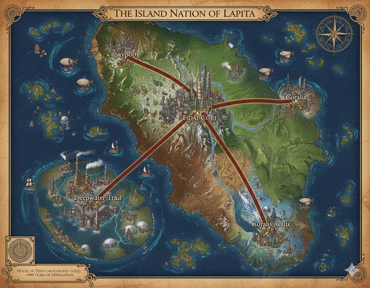
This map, titled “The Island Nation of Lapita,” is rendered in a detailed, antique cartographic style, complete with a compass rose and an ornate border. It showcases a large primary continent surrounded by numerous smaller islands and archipelagos, all set within a vast ocean. The cartouche in the lower-left corner bears the seal of the “House of Tides Cartograph Guild” and notes “Over 9000 Years of Exploration,” grounding the map within the nation’s deep history. The landscape is teeming with activity, including numerous airships, sailing vessels, and settlements, illustrating a vibrant and interconnected society.
Prominently featured are major arterial roads, depicted as thick, red-lined routes that originate from a central megacity. These roads traverse diverse biomes—including verdant northern highlands, arid central plains, and lush eastern coastlines—before terminating at other major cities. These routes also function as the political boundaries for the nation’s internal states. Major rivers are shown winding through the landmasses, busy with the traffic of commerce ships that connect inland areas to the coastal ports.
Major Cities and Locations
Tidal Core Located near the geographic center of the main continent, Tidal Core is the nation’s capital and largest megacity. It is depicted as a sprawling metropolis dominated by colossal skyscrapers that pierce the clouds, showcasing advanced magical and steam-powered engineering. As the central hub of the nation’s transportation network, all major roads emanate from this city, connecting it to the key coastal centers of power and trade. Its position at the heart of the nation signifies its role as the seat of governance for the House of Tides and the epicenter of Lapita’s political, economic, and cultural life. The city is nestled at the edge of a mountainous region, overlooking a vast, drier plain to the south.
Skyport Situated in the verdant, mountainous region of the northern coast, Skyport lives up to its name. The city is a major hub for aerial travel, with numerous airships and zeppelins visible in the skies around it. The road from Tidal Core cuts directly through the northern highlands to reach this city, suggesting a vital connection for trade and transport. Its strategic location likely makes it a center for griffon riders and airship fleets, controlling the northern skies and trade routes.
Coralis Nestled on the eastern coast, Coralis is a major port city in a lush, tropical-looking environment, characterized by waterfalls and vibrant green landscapes. The city itself appears to be a significant center for maritime commerce, with ships active in its harbor. The “Coralis Route” extends south from the main road, linking the primary city of Coralis to another substantial coastal settlement, indicating a highly developed and populated eastern seaboard. The city’s name suggests its proximity to rich coral reefs, making it a likely center for the Marisal population and for trade in aquatic resources.
Deepwater Trail Located on a large archipelago to the southwest of the main continent, Deepwater Trail is depicted as a heavily industrialized zone. The islands are dense with factories, smoking chimneys, and intricate networks of pipes, all indicative of massive steam-powered industry. The presence of large, domed underwater structures connected to the surface islands suggests significant underwater population centers and manufacturing facilities. This area serves as a vital industrial heartland, likely responsible for crafting the gear, vessels, and alchemical goods that fuel Lapita’s economy and exploration efforts. The route leading here from Tidal Core is named the “Deepwater Trail,” emphasizing the importance of this industrial complex.
Points of Interest
- Transportation Networks: The map clearly illustrates a tripartite transportation system. The prominent red roads show a well-developed terrestrial network for overland caravans and travel. The abundance of sailing ships in every corner of the map points to a robust maritime trade economy connecting the islands. Finally, the sky is filled with hot air balloons, zeppelins, and other airships, signifying that aerial transport is commonplace for travel and commerce between the nation’s high-altitude and remote locations.
- Unnamed Settlements: Beyond the major named cities, the map is dotted with smaller towns, villages, and structures along the coasts, rivers, and even in the more remote wilderness areas. This indicates a high population density and that the entirety of the nation is settled, not just the major urban centers.
- Diverse Biomes: The cartography showcases a world of immense environmental diversity. There are towering green mountains in the north, arid badlands in the south-central region, dense jungles along the eastern coast, and scattered islands with unique topographies. This variety of landscapes provides a wide range of resources and challenges for the inhabitants of Lapita.
Secondary Communities
Beyond the major metropolises, the map of Lapita reveals a nation teeming with smaller, secondary settlements that form the backbone of its society.
- River Towns: Along the major rivers, particularly the one flowing east to the Coralis Route, are numerous smaller towns and hamlets. These communities likely thrive on riverine trade, fishing, and agriculture, taking advantage of the fertile floodplains. They serve as vital rest stops and local markets for goods being transported between the coast and the interior.
- Coastal Villages: The entire coastline is dotted with fishing villages and small port towns, especially concentrated along the eastern seaboard. These settlements specialize in shipbuilding, fishing, and harvesting aquatic resources like enchanted kelp and coral. They are the first point of contact for many smaller trading vessels and are essential for maintaining the nation’s maritime dominance.
- Industrial Outposts: The archipelago housing Deepwater Trail is surrounded by smaller islands that feature specialized industrial facilities. These are likely company towns dedicated to a single purpose, such as ore processing, steam-power generation, or alchemical refinement, supporting the massive manufacturing efforts of the main complex.
- Highland Strongholds: Nestled in the northern mountains near Skyport are isolated structures that appear to be mining outposts, fortified monasteries, or griffon aeries. These communities are hardy and self-sufficient, focused on extracting resources from the mountains and maintaining control over the strategic northern passes.
Trade and Commerce Routes
Lapita’s economy is sustained by a complex network of trade routes utilizing land, sea, and air.
- Overland Roads: The main roads serve as the primary arteries for heavy goods.
- The Skyport Road: Transports minerals, timber, and griffon-related goods south to Tidal Core and returns with finished products and food supplies.
- The Coralis-Tidal Core Road: A bustling route carrying seafood, agricultural products, and imported goods inland from the coast, while manufactured items from the capital flow outwards.
- The Deepwater Trail: This vital road is used to transport raw materials and food to the industrial heartland and to bring finished gear, alchemical firearms, and steam-powered machinery to Tidal Core for national distribution.
- Maritime Routes: The ocean is Lapita’s lifeblood, with several key sea lanes.
- The Coastal Run: A busy shipping lane connecting the chain of cities and villages along the eastern coast. It facilitates local trade in food, textiles, and everyday goods.
- The Industrial Artery: A heavy-traffic route for massive cargo ships moving between Deepwater Trail and the major ports of Coralis and Skyport. This is the primary route for the export of Lapita’s manufactured goods and the import of bulk raw materials.
- The Explorer’s Passage: Routes leading from all major ports into the uncharted waters, used by sanctioned exploratory fleets seeking new islands, resources, and ancient ruins.
- Aerial Routes: The skies are filled with airships on routes that mirror the roads, specializing in rapid transport for passengers, mail, and high-value, low-weight cargo such as precious metals, magical components, and political envoys. Skyport serves as the primary hub for all national and international air travel.
Natural Resource Zones
The nation’s diverse biomes provide a wealth of resources that fuel its magical and steam-powered industry.
- Northern Highlands: This region is a primary source of minerals and precious ores extracted through extensive mining operations. The vast, old-growth forests provide high-quality magical timber used in shipbuilding and construction. The high altitudes are also home to rare alchemical herbs and are the natural habitat of the griffons used in transport and racing.
- Eastern Coastlands: The lush, tropical environment around Coralis is the nation’s breadbasket, supporting large-scale agriculture and aquaculture. The waters are rich with enchanted coral reefs and kelp forests, providing key components for Marisal construction and magical gear. The powerful rivers in this zone are likely harnessed for hydro-magical energy.
- Central Plains and Badlands: While seemingly arid, this region is the primary source of stone and clay for construction and pottery. The unique geological conditions make it rich in magical sands (essential for tempering gear) and other alchemical minerals that form in dry environments.
- Southwestern Archipelago: These volcanic islands are a hub of geothermal activity, providing a near-limitless source of energy for Deepwater Trail’s steam forges. The deep waters surrounding the archipelago are harvested for rare aquatic creatures, abyssal crystals, and unique metals found only near volcanic sea vents.
Terrain and Topography
The physical landscape of Lapita is as varied as its culture, shaping the lives of its inhabitants.
- The Central Spine: A formidable mountain range runs down the center of the continent, acting as a natural barrier and influencing weather patterns. Tidal Core is built directly into the foothills of this range, giving it a defensible, commanding position.
- River Deltas: The rivers flowing to the eastern coast have created wide, fertile deltas. This flat, marshy terrain is ideal for agriculture and is the location of many smaller farming and fishing communities that support the larger cities.
- Sheer Cliffs and Fjords: The southern coastline and parts of the northern highlands are characterized by dramatic cliffs and deep fjords. While breathtaking, this rugged terrain makes sea access difficult except in specific, well-defended ports.
- Volcanic Archipelago: The southwestern islands are geologically active, with smoking volcanoes and black sand beaches. The very terrain here is a resource, providing heat, energy, and unique minerals essential to the nation’s industrial power.