
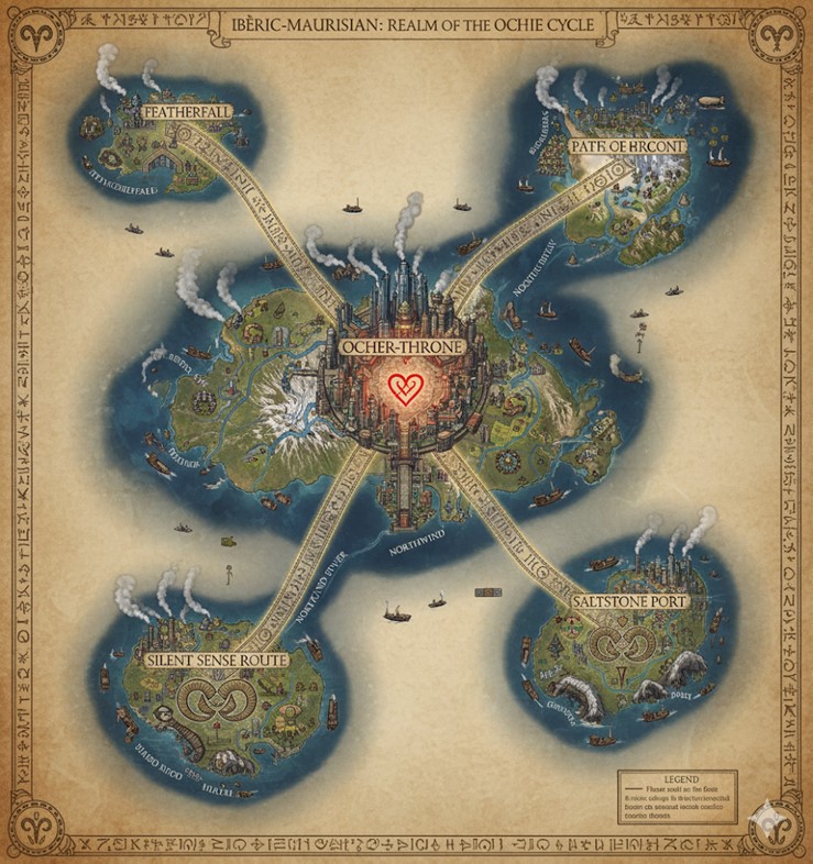
This national map, titled “Ibēric-Maurusian: Realm of the Ochre Cycle,” depicts the island nation as a cluster of five major landmasses set in a vast ocean. The overall aesthetic is that of an aged parchment, with intricate details and labels written in the Mauresque Glyphic Script, which also forms an elaborate border around the entire map. The geography is characterized by a large, central main island dominated by a snow-capped mountain, from which four smaller, significant islands are arrayed in a rough “X” pattern.
The nation is a hub of activity. Numerous ships, including both traditional sailing vessels and steam-powered craft, traverse the waterways between the islands, indicating a robust system of maritime trade and commerce. In the skies, hot air balloons and zeppelins can be seen, suggesting that air travel is also a common mode of transport. The entire map is rendered with a high level of detail, showing forests, mountain ranges, rivers, and settlements.
Four great roads, inscribed with glyphs, emanate from the central capital city, radiating outwards to the four corners of the central island and serving as the primary arteries for land-based travel. These roads also act as the political boundaries for the nation’s major states or provinces.
Major Cities and Regions
Ocher-Throne Located at the absolute heart of the central island and the nation itself, Ocher-Throne is a sprawling megacity of immense scale. It is a marvel of magi-steam industrial engineering, with countless skyscrapers and towering structures packed densely together. Plumes of steam rise from the city, indicating the constant industry that powers the nation. At its very center, a massive, glowing red heart is depicted, representing the Heart-Stone, the sacred artifact that contains the Grinding Shadow and serves as the foundation of the nation and the First Throne. All major roads and rivers converge on or originate from Ocher-Throne, cementing its status as the political, economic, and spiritual nucleus of Ibero-Maurusian. The city is built on and around the slopes of the great central mountain, the highest peak of the Khenifra’s Spine range.
Featherfall Situated on the large island to the northwest, Featherfall appears to be a significant city, though smaller than the capital. Like Ocher-Throne, it is an industrial center, with plumes of steam indicating the presence of steam-powered factories. Its position on the coast of the island suggests it is also a port city. The region is labeled “Austere” and “Riverfall,” and a major river flows near the city, likely providing power and a route for commerce to the island’s interior. A major trade route, the “Riverfall” road, connects Ocher-Throne to the coast facing Featherfall.
Patr of Hrcont This major city occupies the northeastern island. The region is dominated by hills and forests and is labeled “North-East Way.” The city itself is another industrial hub, built along the coast and featuring prominent smokestacks. It is a crucial node in the nation’s trade network, connected to the capital via the “North-East Way” road and a busy sea lane filled with ships.
Saltstone Port Located on the southeastern island, Saltstone Port is, as its name implies, a major maritime center. The city is nestled in a coastal region characterized by rugged, cliff-lined shores and mesas. The large number of ships in the surrounding waters highlights its importance as a port for trade and travel. It appears to be the primary connection point for the southern regions of the nation, linked to Ocher-Throne by the “Northwind” road.
Silent Sense Route The southwestern island is dominated by a region known as the Silent Sense Route. Unlike the other islands, a single major city is not explicitly named. Instead, the area is defined by a massive, serpentine stone formation that coils around the island, resembling a great serpent. This geological feature is likely a site of great spiritual or cultural importance. Several smaller settlements are visible along the coast and within the serpent’s coils. The region is connected to the capital by the road labeled “Northwind and River.” This area’s unique name and geography suggest it may be a place of pilgrimage or have a special connection to the Mechta’s “earth-sense.”
Points of Interest
- The Four Great Roads: Radiating from Ocher-Throne, these massive, glyph-inscribed causeways are the primary land routes. They are named for the regions they traverse: Riverfall (northwest), North-East Way (northeast), Northwind (southeast), and Northwind and River (southwest). They also serve as the formal boundaries between the nation’s states.
- Khenifra’s Spine: This is the name of the formidable, Atlas-like mountain range that dominates the central island. The highest, snow-capped peak rises from the center of Ocher-Throne itself, symbolizing the mountain where the Mechta hero Khenifra retrieved the Heart-Stone.
- Major Rivers: Several large rivers originate in the Khenifra’s Spine range and flow outwards to the coasts. The map shows these rivers are navigable, with numerous vessels using them to transport goods from the interior to the coastal cities and vice versa, forming a critical part of the nation’s commerce.
- The Heart-Stone: Visually represented as a glowing, anatomical heart at the center of Ocher-Throne, this is the nation’s most sacred and important artifact. Its central placement on the map underscores its importance to the stability and identity of the Ibero-Maurusian people.
- Mauresque Glyphic Script: All labels on the map, from the title and city names to the legend and decorative border, are rendered in the elegant Mauresque Glyphic Script. This reinforces the deep connection between the nation’s identity and its rediscovered ancient language.
- Legend: A legend in the bottom right corner, written in the flowing script, provides a key to the map, though the specific details are represented by glyphs. It appears to denote features such as cities, rivers, and possibly different types of terrain or resources.
Secondary Communities & Settlements
Beyond the five major named population centers, the map is dotted with numerous smaller communities, each serving a specific role in the nation’s ecosystem.
- Coastal & Fishing Villages: Along the jagged coastlines of every major island, small clusters of buildings can be seen. These are likely self-sufficient fishing villages that provide a steady supply of seafood to the inland cities. They serve as the first link in the nation’s food chain and as local hubs for coastal trade, using smaller vessels to move goods between nearby settlements before they reach the major ports.
- River Towns: Several smaller towns are situated along the banks of the major rivers flowing from the central mountain. These settlements are positioned to take advantage of the fresh water and fertile land in the river valleys. They likely function as agricultural centers, farming communities, and inland trading posts, using the rivers as highways to ship produce and raw materials to the larger cities.
- Waystations & Mining Outposts: While not explicitly drawn, the presence of the Four Great Roads and the mountainous terrain implies the existence of smaller communities dedicated to supporting this infrastructure. Fortified waystations would exist along the roads to protect travelers and trade caravans. In the foothills of the Khenifra’s Spine, numerous mining outposts would be established, dedicated to extracting the mineral and magical resources that fuel the nation’s steam-powered industry.
- Monastic & Spiritual Enclaves: On the southwestern island of the Silent Sense Route, the settlements appear smaller and more isolated. Positioned within the protective coils of the great serpent rock formation, these communities may be monastic enclaves or spiritual retreats for adherents of the Path of the Ochre Cycle, dedicated to studying the “earth-sense” and communing with the primal spirit of the land.
Trade Routes & Economic Flow
The lifeblood of the nation is its constant flow of commerce, which moves through distinct, interconnected routes.
- Primary Maritime Routes: The heaviest concentration of large ships is seen on the direct sea lanes connecting Ocher-Throne‘s coastal access points with Featherfall, Patr of Hrcont, and Saltstone Port. These are the main arteries for bulk cargo—transporting raw materials like timber, ore, and stone to the capital, and distributing manufactured goods back to the outer territories.
- Coastal Trade Network: A web of smaller routes, plied by smaller vessels, connects the numerous coastal villages to their regional hubs. This allows for the efficient collection of local goods like fish, salt, and agricultural products, which are then consolidated at the major ports for national distribution.
- Aerial Transit Corridors: The airships, zeppelins, and hot air balloons follow direct, high-altitude paths between the major cities. Given the slower speed of sea travel, these aerial routes are likely reserved for high-priority cargo, official government and military transport, wealthy merchants, and urgent communications, representing the pinnacle of Ibero-Maurusian transport technology.
Natural Resource Zones & Terrain
Each island and region possesses a distinct terrain that dictates its primary economic output and contribution to the nation.
- Khenifra’s Spine (Central Island): The terrain here is dominated by the extremely rugged, high-altitude Khenifra’s Spine mountain range. This area is the nation’s primary source of minerals, precious metals, and raw magical components. Its steep, rocky slopes are rich with ore veins and stone quarries, providing the essential materials for the magi-steam industry. The terrain is largely unsuitable for major agriculture, making the capital dependent on the other islands for food.
- Riverfall Valley (Northwestern Island): This island is characterized by the most prominent and fertile river valley on the map. The terrain is lush and green, with wide plains surrounding the river. This region serves as the agricultural heartland of Ibero-Maurusian, producing the vast quantities of grain, livestock, and produce required to feed the nation’s 137 million citizens.
- The Verdant Hills (Northeastern Island): The landscape around Patr of Hrcont is defined by rolling hills covered in dense forests. This makes the region the center of the nation’s timber and lumber industry. The vast forests provide the wood necessary for constructing buildings, ships, and the intricate components of steam-powered machinery. The hilly terrain would also be suitable for raising livestock like mountain goats or sheep.
- The Arid Mesas (Southeastern Island): The region around Saltstone Port appears more arid, featuring high coastal cliffs and flat-topped mesas. As its name suggests, this area is likely the primary source of salt, harvested from coastal flats or mined from stone deposits. The unique geology could also make it a source for specific types of high-quality sandstone or clay used in construction and crafting.
- The Serpentine Wilds (Southwestern Island): The terrain of the Silent Sense Route is rocky and wild, dominated by the colossal, coiling rock formation. This island seems less exploited for industrial resources and is likely maintained as a protected natural or spiritual zone. Its resources would be more subtle—rare herbs, unique fauna, or sites of potent magical resonance, carefully managed by the communities that inhabit the island.