
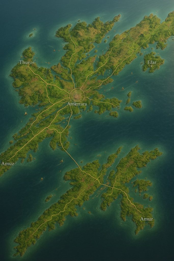
The island nation of Gerzean stretches across a sprawling archipelago of rugged peninsulas and inland valleys. The landmass is cut by multiple rivers running from inland plateaus to the sea, forming fertile deltas and supporting commerce. Roads radiate from the central capital megacity of Amentara, cutting across the island and dividing it into at least three major states. Coastal cities anchor the road network, each thriving on distinct aspects of Gerzean culture and trade.
The coasts are deeply indented with bays, fjords, and natural harbors. Smaller islands scatter offshore, many dotted with villages or left wild, serving as fishing grounds or ritual sites tied to the Path of the Coiled Reed. Green belts of farmland hug the rivers, while stepped pyramids, reed-temple complexes, and steam forges mark city centers.
Major Cities
1. Amentara (Capital Megacity)
- Location: Near the geographic center of the island, where rivers converge.
- Role: Political, cultural, and religious capital; home of the House of Amentet.
- Features:
- Massive stepped pyramid temples dedicated to Gerzara.
- Steam-powered aqueducts channel water into factories and markets.
- Central hub for riverine commerce, with ports extending along artificial canals.
- Universities and libraries house bark-scroll records, giving bonuses for Mind’s Eye research.
- Population: ~5 million, the largest in the nation.
2. Thuros (Western Coast)
- Location: Western peninsula, a major coastal port city.
- Role: Primary trade hub linking Gerzean to other island nations.
- Features:
- Harbors with floating reed markets, anchored by enchanted stone.
- Shipyards constructing steam-powered vessels and zeppelins.
- Known for fishing fleets and salt exports.
- Festivals here often celebrate the uncoiling of reeds, tied to seasonal fertility rites.
- Population: ~2.4 million.
3. Efar (Eastern Coast)
- Location: Eastern peninsula, projecting into the sea with sheltered inlets.
- Role: Commercial and industrial powerhouse, fueled by nearby river systems.
- Features:
- Large steam factories producing alchemical firearms and reed-based gear.
- Strong religious presence with temple-pyramids that guard major deltas.
- Commerce centers around pigment palettes and pottery for magical conduits.
- Known for chanting competitions in Kherzean, drawing avatars from across Saṃsāra.
- Population: ~3.1 million.
4. Amuz (Southern Peninsula)
- Location: Sprawling southern coastal city connected by wide road networks.
- Role: Agricultural and ritual heartland, supplying grain, reeds, and clay.
- Features:
- Vast irrigated fields and reed-beds feeding the nation’s food and mana supplies.
- Burial complexes and funerary reed-wrapping rites are strongest here.
- Houses workshops for pottery conduits that amplify chants by up to 25%.
- A key staging ground for quests into jungle interiors and unsafe areas.
- Population: ~2.7 million.
Points of Interest
- Major Rivers:
- The Serpent’s Flow: A winding river from the highlands to Amentara; main artery for river commerce.
- The Silver Current: Eastern river feeding Efar’s factories, often glowing faintly under magical ebbs.
- The Coiled Waterway: Southern river delta supporting Amuz’s agricultural output.
- Commerce:
- River barges transport pottery, clay vessels, alchemical reagents, and mana reeds.
- Roads act as state boundaries, splitting Gerzean into three regions: the Western Trade State, the Central Sacred Basin, and the Eastern Forge State.
- Religious Monuments:
- Stepped clay pyramids line the rivers near Amentara and Efar.
- Rural shrines of coiled reeds double as safe areas, tripling AC under temple wards.
- Secondary Settlements:
- Inland river towns host crafts guilds producing enchanted textiles and vine-woven gear.
- Offshore islets support monster-integrated enclaves, where non-people civilizations thrive under alliances.
- Natural Landmarks:
- Volcanic Fringes in the southeast: ash fields marking deathly areas where AC nullifies.
- Jungle Ruins in the south: forgotten proto-Gerzean temples overgrown with bioluminescent flora.
- Floating Market Lagoons: anchored by magic reeds, hosting international trade fairs.
Secondary Communities
While the megacity of Amentara and the major coastal cities dominate Gerzean’s identity, the island is woven together by hundreds of secondary communities that specialize in resources, craftsmanship, and cultural traditions.
- River Delta Towns:
Settlements such as Kherun (north of Amentara) and Mazura (south of Efar) thrive on irrigated farmlands. These towns are renowned for pottery workshops, where vessels are crafted both for daily use and as conduits for magical storage. They serve as critical waypoints for barge traffic, offering inns and libraries where Mind’s Eye users gain advantages when cross-referencing artifacts. - Highland Villages:
Perched along ridgelines, towns like Luthen and Sameret harvest timber, stone, and wild reeds. Their location makes them adept at monitoring unsafe zones—highlands often blur into magical ebbs where monsters roam. These villages double as scouting posts, relaying threats toward the capital. - Coastal Fishing Hamlets:
On the scattered islets around Gerzean’s coasts, communities like Bharu and Zeren support fleets of reed and clay-hulled boats. They supply salted fish and seaweed for both mundane diets and alchemical reagents, while also participating in reed-wrapping rituals for funerary practices. - Cave Settlements:
Beneath the central plateau, subterranean communities like Dothren have carved vast chambers lit by mana crystals. These centers specialize in fermentation vats producing mana-brews used in roleplayed meals for HP restoration. They also attract avatars with Isekai knowledge of subterranean engineering.
Trade Routes
Gerzean’s prosperity rests on its interwoven network of land roads, rivers, and coastal shipping lanes.
- Road System:
The radial highways from Amentara mark boundaries between three states—the Western Trade State, the Central Sacred Basin, and the Eastern Forge State. Each highway is lined with toll shrines, where priests of the Path of the Coiled Reed bless travelers with safe passage while collecting taxes. - River Routes:
- The Serpent’s Flow carries barges of grain and reeds into Amentara’s central markets.
- The Silver Current delivers ore and pigments from the eastern uplands to Efar’s factories.
- The Coiled Waterway sustains southern Amuz with fertile silt, enabling vast exports of rice and clay vessels.
Riverine commerce is so essential that gestalt-linked ferrymen share senses across miles to coordinate movements and avoid collisions during magical ebbs.
- Maritime Lanes:
Trade ships sail from Thuros and Efar to connect Gerzean with the other island nations of Saṃsāra. Floating reed-markers ward off unsafe currents, while griffon riders patrol overhead. Amuz’s southern ports act as staging grounds for international zeppelin routes.
Natural Resource Zones
Gerzean’s wealth is tied to zones of concentrated resources, each with both mundane and magical significance.
- Agricultural Plains:
The southern and central valleys around Amentara and Amuz are vast fields of rice, reeds, and legumes. These plains not only feed the nation but also produce mana-rich reeds used in belts, staffs, and conduits. - Clay and Pigment Quarries:
Along the eastern plateau near Efar, deposits of colored clays and minerals support Gerzean’s palette industry—used in ritual grinding to amplify chants. These pigments are key trade goods and religious offerings. - Forested Highlands:
The western interior supports dense forests of vine-wrapped trees. Timber harvested here feeds steam factories and shipyards in Thuros. The forests are also home to monster civilizations, integrated into trade by supplying rare alchemical saps. - Mana Crystal Caves:
Beneath the central plateau, natural caverns glow with embedded crystals. These sites are heavily guarded, as they provide material for Mind’s Eye enhancements and planar communication conduits. - Volcanic Ash Fields:
In the southeast fringes, dormant volcanic vents create deathly zones where AC is nullified. Despite danger, these areas are mined for obsidian and basalt, materials prized for reinforcing clay structures.
Terrain Notes
- Rivers and Deltas: Gerzean’s geography is defined by its rivers, which carve fertile basins before splitting into labyrinthine deltas rich in reeds and fish. These areas are also spiritual centers, believed to be where Gerzara first coiled reeds from mud.
- Jagged Coastlines: The nation’s perimeter is broken into countless peninsulas and coves, making it ideal for harbors but difficult for invaders to navigate. Coastal reefs are enchanted to shift slightly with magical tides, deterring enemy fleets.
- Jungles of the South: Dense, humid jungles conceal forgotten temples with proto-Kherzean glyphs. Many quests originate here, requiring adventurers to uncover relics or confront monster gestalts.
- Floating Markets: Certain lagoons in the west and south are stabilized with woven reed platforms. These floating cities are seasonal, appearing during festivals where trade flourishes under magical wards that triple AC.