
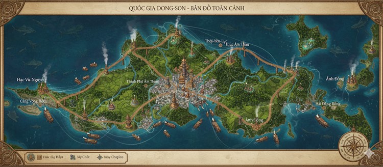
The map, titled “QUỐC GIA DONG-SON – BẢN ĐỒ TOÀN CẢNH” (Dong-Son Nation – Panoramic Map), depicts a large, primary island surrounded by a turquoise sea and several smaller isles. The nation’s geography is a blend of lush, green forests, terraced agricultural plains, and rugged hills, all interconnected by a network of major rivers and well-defined roads. The overall aesthetic is that of a magically-driven industrial society, where towering bronze structures coexist with the natural landscape. A massive, centralized capital city serves as the hub from which all major infrastructure radiates, emphasizing a highly organized and centralized governance structure. The seas are teeming with both marine life and numerous steam-powered merchant vessels, highlighting the nation’s reliance on maritime trade and commerce.
Major Cities
The nation is anchored by a central megacity and several vital coastal ports, each connected by a robust road network.
- Thành Phố Âm Thanh (The Resonant City) Located at the very heart of the island, Thành Phố Âm Thanh is the capital and a sprawling megacity. It is depicted as the industrial, political, and cultural core of Dong Son. The city is a dense collection of towering, bronze-colored skyscrapers and structures that resemble massive temple gongs or bells, with smoke billowing from countless chimneys, indicating constant forge and factory activity. Its central position allows it to function as the primary node for the nation’s road and river systems, reinforcing its dominance. All major roads originate from its towering gates, connecting it directly to the coastal hubs.
- Cảng Vọng Hồi (Echoing Harbor) Situated on the far western coast, Cảng Vọng Hồi is a major port city. The road from the capital runs directly to it, traversing vast agricultural plains. The harbor is bustling with ships, signifying its role as a primary center for maritime trade and the import/export of goods produced in the western territories and the capital. The city itself appears to be a mix of industrial port facilities and urban settlements nestled against the coast.
- Thủy-Yên-Lục (The Jade Water City) This northern coastal city is strategically positioned on a peninsula, connected to the mainland by a long, impressive bridge that spans a wide strait. Its location suggests it serves as the nation’s primary northern naval base or trading post. The surrounding area is heavily forested, and the city seems to be a gateway to the northern territories and the open sea beyond.
- Hải Đăng Rồng (Dragon Lighthouse Port) Located on the southeastern tip of the island, Hải Đăng Rồng is another crucial coastal city. Its name suggests the presence of a significant lighthouse, guiding the heavy ship traffic seen in the southern waters. The city is nestled in a bay, protected by a peninsula and a smaller island, making it an ideal natural harbor. It serves as the main commercial hub for the eastern part of the nation.
States and Regions
The major roads branching from the capital form the boundaries of the nation’s primary states or provinces.
- Hạc-Vũ-Nguyên (The Crane Dance Plain) This is the western state of Dong Son, stretching from the capital to the coast and encompassing the port city of Cảng Vọng Hồi. The map shows this region is dominated by vast, green, terraced fields, likely for agriculture, indicating it is the nation’s primary food source. Several rivers wind through these plains.
- Thác Âm Than (The Resonant Waterfall) The northern state, containing the city of Thủy-Yên-Lục. This region appears more rugged and forested than the western plains. Its geography is defined by hills and dense woods, suggesting it could be a source of timber, resonant bamboo, and other natural resources.
- Ánh Đồng (The Bronze Light) This large eastern state covers the entire southeastern portion of the main island and includes the port of Hải Đăng Rồng. The terrain is a mix of forests, hills, and coastal areas, with several smaller settlements visible. This state also appears to administer the smaller islands located off the eastern coast, which have their own small towns and outposts.
Points of Interest
- River Network and Commerce: A sophisticated network of rivers flows from the island’s central highlands to the sea. These waterways are not merely natural features; they are vital commercial arteries. The map depicts dozens of steam-powered vessels navigating the rivers, transporting goods between the inland regions, the capital, and the coastal ports.
- Infrastructure: The nation boasts impressive feats of engineering. The roads are paved and well-maintained, forming a clear and efficient transportation grid. The long bridge leading to Thủy-Yên-Lục is a standout example, showcasing the architectural and metallurgical prowess of the Dong Son people.
- Smaller Settlements: Beyond the major cities, numerous smaller towns and industrial outposts are scattered across the landscape. These settlements are typically situated along rivers or roads, often featuring the same tall, bronze structures seen in the capital, acting as smaller hubs for local industry, resource gathering, or agriculture.
- The Archipelago: Dong Son is not a single landmass but an archipelago. Several smaller islands lie to the east and northeast. Some are large enough to support settlements and are connected by sea routes, playing a role in the nation’s economy and defense.
Secondary Communities and Settlements
Beyond the major cities, the island is dotted with numerous smaller, yet vital, secondary communities that form the backbone of the nation’s economy and social structure.
- River Towns: Positioned along the major river networks, these towns are crucial hubs for inland transport. They serve as local trading posts where goods from the surrounding areas are collected before being loaded onto barges for shipment to the capital or coastal ports. Many of these settlements are built around large, drum-powered waterwheels, which power local forges, mills, and irrigation systems.
- Agricultural Hubs: Located throughout the vast western plains of Hạc-Vũ-Nguyên, these settlements are centers for the region’s agricultural output. They consist of communal storage silos, processing facilities for rice and alchemic reeds, and local markets. Their architecture, while smaller in scale, mimics the resonant bronze-gong style of the capital.
- Forge-Steads and Mining Outposts: Nestled in the hills and forests of the northern state, Thác Âm Than, these communities are focused on resource extraction. They are built near mine entrances for copper and tin ore or in clearings where resonant bamboo is harvested. These outposts are often shrouded in steam and smoke from the preliminary smelting forges that reduce the ore’s weight before transport.
- Coastal Fishing Villages: Along the less-developed stretches of the coast, particularly in the eastern state of Ánh Đồng, are smaller fishing villages. They supply fresh seafood to the nation and are also involved in harvesting phosphorescent algae and other marine resources from the spiral delta marshes.
Trade and Commerce Routes
Dong Son’s prosperity is built on a highly efficient, multi-layered network of trade routes that facilitate the constant flow of goods and people.
- Land Routes:
- The Great Bronze Roads: The three main highways radiating from Thành Phố Âm Thanh are more than just roads; they are masterworks of civic engineering. Paved with resonant stone blocks tuned to the nation’s foundational rhythm, they allow for the rapid movement of industrial goods, military units, and official traffic.
- Local Paths: While not explicitly detailed, a network of smaller paths and roads can be inferred, connecting the agricultural hubs, mining outposts, and river towns to the Great Bronze Roads, ensuring no community is truly isolated.
- Maritime & River Routes:
- River Arteries: The rivers are the primary conduits for bulk transport. Raw materials like timber, ore, and quarried stone are floated downriver on large, steam-powered barges to the industrial centers. In return, manufactured goods and processed foods are shipped back upriver to the inland communities.
- Coastal Shipping Lanes: A constant stream of merchant vessels travels the coastal waters, connecting the major ports of Cảng Vọng Hồi, Thủy-Yên-Lục, and Hải Đăng Rồng. This route allows for rapid redistribution of goods around the island without needing to go through the capital.
- International Trade Corridors: The heavy ship traffic moving away from the main ports indicates extensive international trade. Cảng Vọng Hồi likely serves western trade partners, Thủy-Yên-Lục manages northern routes, and Hải Đăng Rồng is the gateway for southern and eastern commerce.
Natural Resource Zones
The island’s varied terrain provides distinct zones for resource production, which the Dong Son culture has masterfully exploited.
- The Great Plains (West – Hạc-Vũ-Nguyên): This region is the nation’s breadbasket. Its vast, mirror-like terraced paddies are dedicated to the cultivation of rice, lotus, and the culturally significant shimmering alchemic reeds. The fertile soil and extensive river-fed irrigation systems make it ideal for large-scale agriculture.
- The Resonant Forests and Hills (North – Thác Âm Than): The rugged, forested north is the primary industrial resource zone. The hills are rich in copper and tin deposits, the essential components of bronze. The subtropical forests are a source of valuable timber and the famed resonant bamboo, which is crucial for construction, tools, and musical instruments.
- The Quarries and Marshes (East – Ánh Đồng): The eastern state is a mixed-resource area. The basalt cliffs along the coast are quarried for the resonant stone used in the nation’s unique architecture. The coastal spiral delta marshes are a source of unique biological components, including phosphorescent algae and reagents used in alchemy. The rich coastal waters also make this the center of the nation’s fishing industry.
Additional Terrain Details
- The Central Plateau: The capital, Thành Phố Âm Thanh, is situated on a commanding central plateau. This elevated position is not only defensible but also serves as the headwaters for the island’s major river systems, granting it control over the nation’s lifeblood.
- Rugged Coastlines: While the west is defined by plains, the northern and eastern coastlines are rugged and dramatic. They are characterized by mist-steeped basalt cliffs, deep bays, and protective peninsulas. These cliffs are riddled with the echo-caves central to the Bronze Resonance Faith, where the wind itself is said to play chords.
- The Eastern Archipelago: The chain of smaller islands off the eastern coast acts as a natural breakwater, protecting the mainland from storms. These islands are likely home to secluded monasteries, naval outposts, or specialized resource harvesting sites, such as quarries for rare minerals or unique gems.