
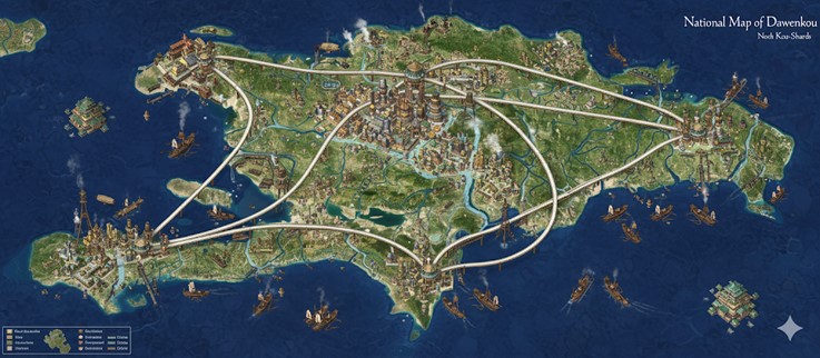
This national map of Dawenkou illustrates a large, verdant island nation characterized by its intricate network of rivers and advanced infrastructure. The island’s geography is dominated by a central mountain range, from which numerous rivers flow outwards towards the coast, creating fertile deltas and coastal plains. A sophisticated system of elevated roadways, seemingly constructed from a pale, smooth material, connects the major population centers. These roads are a testament to the nation’s engineering prowess, traversing varied terrains including rivers, forests, and mountainous regions. The architectural style of the cities is a blend of traditional, multi-tiered structures and advanced, almost futuristic designs, suggesting a society that honors its past while embracing technological and magical progress. The surrounding seas are bustling with maritime activity, featuring a variety of vessels from traditional sailing ships to more advanced, possibly steam-powered, craft. The presence of smaller, fortified islands and floating structures indicates a nation that has mastered both land and sea. The overall impression is one of a prosperous, organized, and technologically advanced civilization living in harmony with its natural environment.
Major Cities
- Huang-Kou (The Capital Megacity): Located near the center of the island, Huang-Kou is the heart of the nation. It is a sprawling metropolis of towering skyscrapers that seem to be built with a combination of metal and a ceramic-like material, reflecting the nation’s pottery-focused culture. The city is a hub of commerce and transportation, with the major elevated roadways converging here. Numerous rivers flow through and around the city, integrated into its urban landscape with canals and bridges. The architecture is a grand display of the nation’s wealth and power, with monumental buildings that likely serve as governmental and guild headquarters. The sheer scale and density of Huang-Kou suggest a population in the millions, making it the political, economic, and cultural center of Dawenkou.
- Biyu (The Western Port City): Situated on the western coast, Biyu is a major port city and a critical node in Dawenkou’s maritime trade network. Its extensive harbor is filled with ships of all sizes, and large cranes and warehouse complexes line the waterfront, indicating a high volume of commercial activity. The city is connected to the capital by a major elevated roadway, facilitating the efficient transport of goods to and from the interior. Biyu’s architecture is more utilitarian than the capital’s, with a focus on functionality and defense. The city is protected by sturdy sea walls and fortified islands, highlighting its strategic importance.
- Tao-Du (The Southern Coastal City): Located on the southern coast, Tao-Du is another significant coastal city, strategically positioned at the mouth of a major river. It appears to be a center for both trade and industry, with numerous workshops and foundries visible. The city’s layout is heavily influenced by the river, which serves as a primary artery for commerce and transportation. Like Biyu, Tao-Du is connected to the capital by an elevated roadway and boasts a bustling harbor. Its proximity to the southern seas makes it a gateway for trade with nations to the south.
- Jin-Hai (The Eastern Harbor City): On the eastern coast, Jin-Hai serves as the primary maritime gateway to the eastern seas. The city is built around a large natural harbor and is a hub for naval and commercial fleets. The presence of what appear to be naval shipyards and drydocks suggests that Jin-Hai is a center for shipbuilding and naval operations. The city is well-fortified, with coastal defenses and a strong naval presence to protect the nation’s eastern flank. A major roadway connects it to Huang-Kou, ensuring that the resources and goods from the east can be easily transported to the capital.
Points of Interest
- The Great Central Mountains: This formidable mountain range dominates the island’s interior. It is the source of the nation’s major rivers and is likely rich in mineral resources, as suggested by the presence of what appear to be mining operations and forges in the foothills. The mountains are also a place of great natural beauty, with mist-shrouded peaks and verdant valleys.
- The Elevated Roadways: These remarkable feats of engineering are a defining feature of the nation’s infrastructure. The roads are raised high above the ground on massive pillars, allowing for rapid and unimpeded travel between the major cities. Their smooth, seamless construction suggests the use of advanced materials and construction techniques, possibly involving magic. The roadways also serve as the boundaries for the nation’s internal states or provinces.
- The River Deltas: The areas where the major rivers meet the sea are characterized by fertile and heavily populated deltas. These regions are the breadbaskets of the nation, with extensive agriculture and aquaculture providing food for the large urban populations. The deltas are also centers of commerce, with numerous smaller towns and villages thriving on the river trade.
- Floating Fortresses and Cities: The seas around Dawenkou are dotted with massive floating structures. Some of these appear to be heavily armed fortresses, serving as mobile defense platforms to protect the nation’s shipping lanes. Others are larger and more complex, suggesting they are self-sufficient floating cities, complete with residential areas, workshops, and docks. These structures are a testament to the nation’s mastery of naval engineering and magic.
- The Airships: Soaring above the landscape are various types of airships. Some are sleek and fast, likely used for transportation and racing, while others are larger and more heavily built, possibly serving as cargo haulers or warships. The presence of these airships indicates that the people of Dawenkou have conquered the skies as well as the seas, further highlighting their advanced technological and magical capabilities.
Secondary Communities
Beyond the major metropolises, the island is dotted with numerous smaller settlements, each serving a vital role in the nation’s economy and society.
- River Towns: Along the banks of the major rivers, especially at the confluence of tributaries, are bustling river towns. These serve as local hubs for agricultural goods from the surrounding farmlands. Barges and smaller riverboats collect produce, rice, and other foodstuffs from these towns, transporting them to the larger coastal cities. A prime example is a significant town located at the first major fork of the river flowing south from the capital, likely a center for freshwater fishing and the collection of river-silt for pottery.
- Foothill Mining and Forge Villages: Nestled in the foothills of the great central mountains are smaller communities dedicated to resource extraction and preliminary processing. These villages are situated near visible cave entrances and what appear to be smoke-pluming forges. They are the source of the ores, clays, and obsidian that are fundamental to Dawenkou’s industry. The architecture here is more rustic and functional, built to withstand the rigors of mining and industrial work.
- Coastal Fishing Hamlets: The coastline is peppered with small fishing hamlets, particularly in sheltered coves and bays not occupied by the major port cities. These communities are essential for the nation’s food supply, providing a steady stream of seafood to the inland populations. They also likely serve as centers for pearl diving and the harvesting of other marine resources.
- Terrace Farming Communes: In the higher elevations, particularly on the slopes of the mountains, are communities built around extensive terrace farming. These communes specialize in crops that thrive at higher altitudes, such as the tea mentioned in Dawenkou’s lore. Their settlements are integrated into the terraced landscape itself, showcasing a deep connection to the land.
Trade Routes
Dawenkou’s prosperity is built on a complex and efficient network of trade routes that crisscross the land and surrounding seas.
- The Elevated “Sky-Roads”: These are the primary arteries for high-speed, bulk transport of valuable goods, raw materials, and personnel between the major cities. The traffic on these roads likely consists of large, steam-powered cargo haulers and faster, smaller vehicles for passengers and official business. The central ring road connecting the four major cities is the most critical, ensuring that resources from any port can reach the capital or another port with unparalleled efficiency.
- Riverine Commerce: The extensive river systems form a secondary, but no less important, trade network. Barges and shallow-draft boats ply these waters, moving agricultural goods from the interior to the coastal cities and distributing finished products back to the rural populations. The rivers are the lifeblood of the agricultural heartland, connecting countless small villages and towns to the broader national economy.
- Maritime Shipping Lanes: The seas are bustling with activity. Large, ocean-going vessels, likely a mix of advanced steamships and traditional sailing craft, connect Dawenkou to the wider world. These ships import exotic goods and raw materials not found on the island and export Dawenkou’s renowned ceramics, advanced steam-tech, and other manufactured products. The presence of naval escorts and fortified islands indicates that these shipping lanes are well-protected. Shorter-range coastal shipping connects the major ports with smaller coastal towns and offshore facilities.
Natural Resource Zones
The island’s diverse geography provides a wealth of natural resources that fuel its advanced civilization.
- The Central Highlands (Mining): The mountainous core of the island is the primary source of mineral wealth. Deposits of iron, copper, and other metals are mined here, along with the high-quality clays (kaolin) essential for the nation’s famous porcelain. The volcanic nature of the range, as mentioned in the lore, also provides obsidian and geothermal energy, which powers many of the forges and steam engines.
- The Great River Plains (Agriculture): The vast plains and deltas created by the rivers flowing from the central mountains are incredibly fertile. This is the agricultural heartland of Dawenkou, where rice paddies, fields of grain, and other crops are cultivated on a massive scale. The river-silt itself is a valuable resource, continuously enriching the soil and providing raw material for pottery.
- The Verdant Forests (Lumber and Foraging): Large swathes of the island, particularly the slopes of the mountains and the less populated areas between river valleys, are covered in dense forests. These provide timber for construction, shipbuilding, and fuel. They are also home to a variety of unique flora and fauna, which are likely foraged for food, medicine, and alchemical ingredients.
- Coastal and Marine Resources: The surrounding seas provide an abundance of fish and other seafood. The presence of what look like specialized barges and platforms in certain coastal areas, especially near the western port of Biyu, suggests large-scale aquaculture operations. The southern littorals are likely home to mangrove forests, providing unique timber and a rich ecosystem for harvesting marine life.
Terrain Information
The island of Dawenkou is a land of dramatic contrasts. The central mountain range is rugged and imposing, with sharp peaks and deep valleys. As one moves away from the center, the terrain softens into rolling foothills and then flattens out into broad, open plains and coastal lowlands. The coastline is a mix of sandy beaches, rocky cliffs, and marshy deltas. The archipelago of smaller islands to the west and the floating fortresses create a complex and defensible maritime environment. The entire landscape is dominated by the presence of water, with the intricate network of rivers and lakes defining not only the geography but also the very way of life for the people of Dawenkou.