
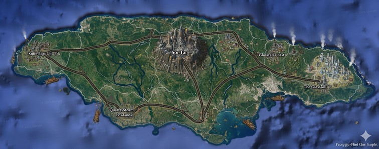
The national map of Clactonian reveals a rugged, oblong island continent defined by a dramatic central highland that gives way to varied and industrious coastal regions. The landmass is characterized by its dark, flint-rich geology, with a jagged coastline marked by black sand beaches and steep cliffs. The island’s geography is dominated by a single, massive volcanic mountain peak at its core, from which the nation’s capital is built. A network of major, heavily constructed roads, appearing as robust railway lines, radiates from this central hub, carving the nation into distinct territories and connecting the interior to the vital coastal ports. Rivers flow from the central elevations, serving as crucial arteries for trade and transport in a land shaped by quarrying and steam power. The surrounding ocean is not empty, but rather dotted with formidable stone-hulled vessels, their smokestacks indicative of the steam-driven engines that power the nation’s commerce and naval might.
Major Cities & Regions
Sor-Tar, The Crownstone Capital: Located near the geographic center of the island, Sor-Tar is a megacity built upon and around the slopes of a great basalt mesa. It is the political, economic, and spiritual heart of Clactonian. The cityscape is a dense vertical fortress of dark stone and metal, with towers and structures climbing the mountain itself. The architecture is severe and angular, reflecting the culture’s focus on fracture and utility. At the pinnacle of the mesa sits the palace of the Crownstone Matriarch, a structure whose facade is ceremonially cracked away and redressed each decade. From this central nexus, all major roads and trade routes originate, carrying the edicts of the Matriarch and the products of the mountain’s forges to the rest of the nation. The city is a hub of constant activity, its air thick with the dust of quarries and the steam from its many forges and engines.
The Glassfall: On the far eastern coast lies the major port city known simply as The Glassfall. It is the nation’s primary gateway to maritime trade. The city is built against a backdrop of unique coastal cataracts where ancient molten silica cooled into towering, translucent cliffs. This sprawling urban center is a contrast to the dark stone of Sor-Tar, with many of its buildings incorporating panes of sharpened glass harvested from the cliffs during annual festivals. It is a bustling metropolis, its harbors filled with stone-hulled trade ships and its streets ringing with the percussive sounds of the Brak-Sor language spoken by sailors, merchants, and the artisans who work the glass. The great eastern road from Sor-Tar terminates here, bringing raw materials from the interior to be shipped across the world of Saṃsāra.
Knife-Edge Uplands: The western portion of the island is dominated by the Knife-Edge Uplands. This is not a single city but a vast, wind-scoured state characterized by high plateaus and treacherous mountain paths. The ground is littered with flint flakes like a form of black snow. The population here is sparse, living in fortified settlements carved directly into the rock faces, often situated near rich flint quarries. The main road through this region connects Sor-Tar to a series of smaller coastal towns that serve as fishing villages and secondary ports. Life in the Uplands is harsh and focuses on the extraction of flint, obsidian, and other valuable stones, which are then transported back to the capital for processing.
Quarry-Steam Lowlands: To the south lies the industrial heartland of the nation, the Quarry-Steam Lowlands. This region is a network of deep valleys perpetually filled with the fog and steam generated by the countless water-fire engines that power the nation’s industry. These engines drive massive sawmills, shard forges, and the machinery used in the extensive quarries that give the region its name. The settlements here are functional and soot-stained, built for efficiency around the engines and quarries. The rivers in this region are heavily trafficked by barges and small steam-craft, carrying quarried stone and forged goods toward the southern coast for trade.
Points of Interest
National Road System: The map clearly illustrates the primary arteries of Clactonian infrastructure. Three major roads, engineered for heavy transport and resembling fortified railways, extend from Sor-Tar to the coasts. One runs west through the Knife-Edge Uplands, another extends east to the port of The Glassfall, and a third pushes south through the Quarry-Steam Lowlands. These roads are more than just transport routes; they serve as the official boundaries for the nation’s primary states or territories, dividing the island into the western Uplands, the southern Lowlands, and the eastern Glassfall Coast.
River Commerce: Several major rivers are visible, originating in the central mesa around Sor-Tar and winding their way to the sea. The largest of these flows southeast, emptying into a large bay, while another significant river snakes through the Quarry-Steam Lowlands. These waterways are vital to the Clactonian economy. They are used to transport immense quantities of raw stone from inland quarries to coastal processing centers and ports. The presence of what appear to be barges and industrial traffic on these rivers highlights their importance as the lifeblood of the nation’s resource-based economy, supplementing the primary road network.
Secondary Communities
Beyond the major population centers, Clactonian is dotted with numerous secondary settlements, each adapted to its specific region. In the Knife-Edge Uplands, towns like Flake-Fall Hold and Akka’s Reach exist not as sprawling communities but as fortified enclaves built into cliff faces and mesas. These are primarily mining and quarrying outposts, home to hardy Fraxari who spend their lives extracting high-grade flint and obsidian. Life here is spartan, revolving around the quarry schedules and the ever-present wind that scours the plateaus.
The Quarry-Steam Lowlands are home to a series of soot-covered industrial towns known collectively as the “Engine-Towns.” Settlements such as Core-Exhaust and Breaker’s Anvil are built around massive steam-engine complexes that power the forges and stone-saws. These communities are functionally designed, with worker barracks and foundries interconnected by a web of pipes and smaller rail lines for ore carts. Near the southern coast, where the rivers form deltas, lie the marsh communities of the Fracture Marshes. Here, in villages like Reed-Crack, locals herd shelled beasts and harvest alchemical reagents from the brackish waters.
The Glassfall Coast, being more temperate, supports a greater variety of settlements. Small fishing villages like Shard-Tide dot the coastline, their inhabitants using sharpened glass tools for their trade. Further inland, in the fertile pockets of river valleys, agricultural communities such as Green-Fracture cultivate the hardy crops that can survive the mineral-rich soil, providing a crucial food source for the more industrial parts of the nation.
Trade Routes and Commerce
The three main roads radiating from Sor-Tar are the backbone of Clactonian commerce. The Western Flint Road is a heavily guarded corridor through the Uplands, primarily used for transporting raw flint and obsidian eastward to the capital’s workshops. The Eastern Glass Road is the most refined of the three, paved with a fused shard-glass composite. It carries finished goods—weapons, tools, and magical carvings—from Sor-Tar to the port of The Glassfall for export. The Southern Core Road is the most industrial, designed to bear the immense weight of quarried basalt and raw metals moving north from the Lowlands. These routes are not simple roads but massive engineering projects, featuring steam-powered waystations and toll-forts at regular intervals.
Riverine trade is essential for bulk transport. The rivers flowing from the central highlands are tamed by steam-powered locks and levies, allowing heavy, shallow-draft barges to haul uncut stone and ore downstream to the forges of the Lowlands and the southern ports.
Maritime trade is Clactonian’s link to the wider world of Saṃsāra. From The Glassfall, stone-hulled merchant vessels ply the eastern seas, trading high-value, expertly crafted goods. The southern ports are grittier, exporting bulk materials like raw basalt blocks and metal ingots. A constant coastal shipping trade connects the smaller villages, with smaller steam-craft ferrying fish, food, and people between the settlements, ensuring that even the most remote parts of the island are tied into the national economy.
Natural Resource Zones
Clactonian’s industry is fueled by its immense geological wealth. The Knife-Edge Uplands are the primary source for the nation’s legendary flint, with entire mountainsides being systematically fractured and harvested. Within the volcanic foothills of this region and near Sor-Tar lie the Ember-Hollow Caverns, subterranean magma-lit chambers that are the world’s richest known source of obsidian. These veins are mined by specialized, night-adapted breaker teams.
The Quarry-Steam Lowlands are a massive resource zone for industrial and construction-grade stone, particularly the dark basalt favored for building. The entire region is a patchwork of enormous, open-pit quarries. Metal deposits, primarily iron and copper, are also found here and in the central mountain range, mined and smelted on-site in the great forges.
The eastern coast holds the unique resource of the Glassfall itself. The translucent silica cliffs are not mined in a traditional sense but are “harvested” annually, providing the raw material for the region’s famed glass-crafting industry. The southern Fracture Marshes are a biological resource zone, valued for their unique fauna and the alchemical herbs that grow in the brackish, mineral-rich environment.
Terrain and Geography
The island’s terrain is a direct product of its violent geological history. The central landmass is the remnant of a massive shield volcano, with Sor-Tar built upon its caldera rim. The surrounding mountain is a labyrinth of old lava tubes, steam vents, and geothermal springs, some of which are harnessed to power parts of the capital. The land slopes away from this central peak, creating the high plateaus of the west and the lower valleys of the south.
The coastline is varied and dangerous. The western and northern shores are battered by open-ocean storms, resulting in sheer cliffs and jagged, shard-like sea stacks. These areas are sparsely inhabited and difficult to approach by sea. In contrast, the southern and eastern coasts lie in the island’s lee, allowing for the formation of deep bays and calmer inlets that are ideal for harbors. The rivers carve deep, sharp canyons through the Uplands, but as they reach the flatter coastal plains of the east and south, they slow and widen, creating fertile deltas and the sprawling, brackish wetlands of the Fracture Marshes.