
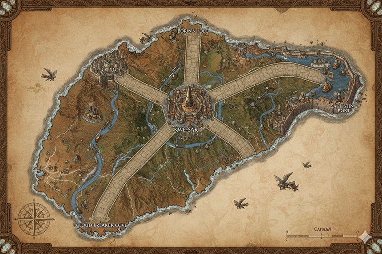
The map depicts the island nation of Capsian as a land of rugged beauty and pragmatic design, rendered in an antique cartographic style on what appears to be aged parchment. The nation’s structure is immediately apparent, dominated by a massive, central megacity, Kwe-Sar, which acts as the hub from which five colossal, master-crafted stone roads radiate outwards to the coasts like the spokes of a great wheel. These roads not only serve as the primary arteries for travel and trade but also act as the formal boundaries for the nation’s internal states.
The island’s geography is a dramatic tapestry of contrasts. Several major river systems snake their way from the interior highlands down to the sea, their banks dotted with smaller settlements and their waters plied by barges, indicating they are vital for internal commerce. The western region is marked by mountains and industry, while the eastern coast is defined by a large, protected bay. The interior is a vast expanse of semi-arid plains and canyons, the domain of the nomadic clans. The presence of Griffons in the skies over the island suggests that flight is a common method for swift travel between key locations.
Major Cities
Kwe-Sar (The Central Hub) Located near the geographic center of the island, Kwe-Sar is the capital and heart of the Capsian nation. It is a sprawling, multi-tiered megacity built with breathtaking verticality, a testament to the climbing prowess of the Sal-Vyr. Instead of stairs, the city is connected by a complex network of steep, textured ramps and grand lifts. As the seat of the matrilineal monarchy, Kwe-Sar is the center of governance, high culture, and master craftsmanship. The central spire, visible from miles away, houses the royal palace and the primary guilds. All five of the Great Roads converge here, solidifying its status as the nexus of all national trade and travel.
Borin’s Hold (The Northern Bastion) Situated on the rugged northern coast, Borin’s Hold is a fortress-city built for resilience. Named after a legendary Sal-Vyr engineer, the city is famed for its massive quarries and its defensive architecture, carved directly into the seaside cliffs. It serves as Capsian’s primary military stronghold and the headquarters of the national navy. The people of Borin’s Hold are known for their stern pragmatism and are considered the finest stone masons and armorers in the nation, providing the raw materials and finished goods that protect and build the country.
Saltesting Port (The Eastern Gateway) Nestled within the calm, deep waters of the great eastern bay, Saltesting Port is Capsian’s largest and most cosmopolitan maritime hub. Its extensive docks and protected anchorages can accommodate hundreds of vessels, from local fishing skiffs to the great merchant galleons of other island nations. This is the primary center for international trade, where raw materials from Capsian’s interior are exchanged for exotic goods from across Saṃsāra. The city is a bustling, vibrant metropolis characterized by its massive warehouses, sprawling markets, and a diverse population of Sal-Vyr merchants and foreign traders.
Cloud-breaker Cove (The Southern Reach) Perched on the windswept southwestern coast, Cloud-breaker Cove is a city defined by its relationship with the often-turbulent open ocean. The Sal-Vyr here are renowned as the most daring sailors and skilled fishers in Capsian. The city is built on and around a series of tall sea stacks and jagged cliffs, connected by rope bridges and carved ledges. It is the main hub for the nation’s fishing fleets and serves as the primary trade link for the agricultural communities and nomadic clans of the southern plains.
Tiloc (The Industrial Heart) In the mountainous west lies Tiloc, the industrial engine of Capsian. The smokestacks rising from the city’s districts indicate the presence of great forges, geothermal-powered workshops, and alchemical manufactories. This is where the ore and minerals quarried from the Western Highlands are smelted, refined, and crafted into the tools, enchanted plates, and mechanical components used throughout the nation. Tiloc is a city of artisans and engineers who work with fire and metal, creating works of function and durability that are the pride of the Sal-Vyr people.
Points of Interest
The Great Roads The five roads radiating from Kwe-Sar are monumental feats of Sal-Vyr engineering. Far more than simple trade routes, they are wide, raised causeways built of precisely cut and magically reinforced stone, smoothed by ages of traffic. Each road is named for the region it leads to (e.g., the Northern Road, the Western Road). They are so significant that they serve as the official borders for the nation’s internal territories, making them fixtures of both geography and politics.
The River Arteries The map shows several vital river systems that act as the lifeblood of the island’s interior. These rivers, such as the major artery flowing from the northern mountains through the plains to Saltesting Port, are crucial for transporting goods like timber, grain, and quarried stone from inland production sites to the coastal cities for trade. Small river towns and trading posts are visible all along their lengths.
The Western Highlands The mountain range dominating the western third of the island is known as the Western Highlands. This rugged and imposing landscape is rich in iron, copper, and precious minerals. It is a land of miners, smiths, and nomadic clans who are uniquely adapted to the high altitudes. The area is dotted with mines, watchtowers, and small, fortified settlements built to withstand harsh weather and protect valuable resources.
The Interior Plains (The Great Etch) The vast, semi-arid grasslands and canyonlands that lie between the Great Roads are known collectively as the Great Etch. This is the traditional territory of the semi-nomadic Sal-Vyr clans who follow the Path of the Etched World. While sparsely populated compared to the coasts, this region is the spiritual heartland of the nation. Hidden deep within its canyons are the sacred “Galleries of Memory,” where millennia of Sal-Vyr history are recorded in breathtaking rock art.
Terrain and Natural Resource Zones
The geography of Capsian is a direct reflection of its culture: stark, practical, and possessing a deep, rugged beauty. The island can be broadly divided into four primary ecological and resource zones.
- The Dragon’s Spine (Western Highlands): The western third of the island is dominated by a formidable, jagged mountain range known as the Dragon’s Spine. These peaks are geologically active, with steam-belching fissures and hot springs that are harnessed by the industrial city of Tiloc. This region is the nation’s primary source of metals and minerals. Rich veins of iron, copper, and tin are carved from deep within the mountains, alongside rarer finds like silver, obsidian, and magically-attuned crystals. The harsh, vertical terrain is treacherous, but the Sal-Vyr’s natural climbing ability makes them uniquely suited to mining its riches.
- The Great Etch (Interior Plains): Sprawling between the great roads is the vast, semi-arid interior known as the Great Etch. This is a massive plateau of sprawling grasslands, punctuated by towering, wind-hollowed mesas and cut by deep, labyrinthine canyons. This zone is the domain of the nomadic clans and the island’s primary source of hides, bone, and spiritual resources. Great herds of hardy, bison-like beasts and large, flightless birds roam these plains, providing sustenance and materials. The canyons are rich with deposits of ochre, charcoal, and other natural pigments considered sacred to the Path of the Etched World, and it is here that the most sacred Galleries of Memory are hidden. Water is the most precious resource, found only in scarce oases and seasonal rivers.
- The Verdant Belt (River Valleys): Carving through the interior plains and flowing from the highlands are several major river systems. The land flanking these rivers forms the Verdant Belt, a relatively lush and fertile region that stands in contrast to the arid plains. These valleys are the breadbasket of Capsian, where hardy grains, tough-skinned gourds, and root vegetables are cultivated. The riverbanks are lined with dense forests, providing a sustainable source of timber for shipbuilding and construction. The rivers themselves yield freshwater fish and clay from their banks, used in pottery and brick-making.
- The Jagged Coast (Coastal Regions): Capsian’s coastline is a long and varied tapestry of sheer cliffs, deep fjords, and windswept beaches littered with massive, water-smoothed stones. This zone is a treasure trove of maritime and trade resources. The ocean is teeming with fish, giant crabs, and deep-water mollusks, whose iridescent shells are highly prized. The shallow bays of the east are home to vast salt pans, providing a crucial preservative. In the turbulent waters of the south and north, magical coral reefs grow, harvested for their potent alchemical properties, while the beaches are a reliable source of flint for tool-making.
Secondary Communities and Trade Routes
While the five major cities are the centers of power and population, the lifeblood of the nation flows from its smaller communities through a network of vital trade routes.
Secondary Communities
- Forge-Villages: Clustered in the foothills of the Dragon’s Spine, villages like Cinder-Fell and Iron-Heft are dedicated to the initial processing of raw ore. These communities are filled with smelters and smiths who turn the rock brought down from the mountain mines into ingots and basic goods, which are then transported to the industrial heart of Tiloc.
- River Towns: Along the fertile banks of the Verdant Belt, towns such as Oakhaven and Claybrook serve as agricultural centers and logging hubs. They are built at key confluences or fords in the rivers, using water-powered mills to process grain and timber before loading the goods onto barges for shipment to the coast.
- Coastal Fishing Villages: All along the coastline, nestled in protected coves or carved directly into the cliff faces, are dozens of smaller fishing villages. Places like Shell-Cling and Tide-Carve are home to hardy Sal-Vyr who live by the rhythm of the sea, harvesting its bounty and mastering the treacherous coastal waters in their small, resilient vessels.
- Nomadic Clan Encampments: The interior plains are not empty but are home to the ever-moving encampments of the Capsian Confederacy clans. These are not permanent settlements but are a crucial part of the social landscape. They move seasonally, following the great herds and making pilgrimages to the sacred Galleries. Their trade is in expertly cured hides, carved bone, and the sacred pigments they gather.
Trade Routes
- River Commerce: The most critical internal trade routes are the rivers. A constant flow of heavy barges moves downstream, carrying metal ingots, timber, grain, and stone from the interior to the coastal cities. Lighter, magically-assisted skiffs carry finished goods and supplies back upstream.
- Caravan Trails: The Great Etch is crisscrossed by a network of ancient, unpaved caravan trails that connect oases, sacred canyons, and trading posts. The nomadic clans use these trails to trade their hides and pigments with the settled Sal-Vyr for metal tools, salt, and grain.
- Coastal Sea-Lanes: A well-established maritime route hugs the coastline, connecting the major port cities. Hardy merchant cogs sail from Cloud-breaker Cove, around the industrial west to Borin’s Hold, and finally to the great harbor at Saltesting Port, trading fish, metal goods, and quarried stone. This route is safer than crossing the open ocean but requires skilled navigation to avoid reefs and treacherous currents.
- International Sea-Lanes: Saltesting Port is the terminus for all international trade. Great ships arrive from other island nations across Saṃsāra, bringing exotic textiles, spices, and magical components, and leaving with holds full of Capsian’s masterfully crafted tools, enchanted stone, and precious metals.