
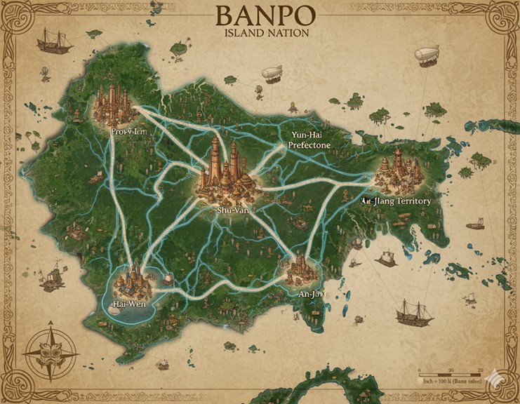
This map depicts the Banpo Island Nation, a large, verdant landmass surrounded by a vast ocean dotted with smaller islands and rock formations. The art style evokes an antique, hand-drawn feel, with a parchment-like background and ornate border details, including a compass rose in the lower-left corner. The island itself is lush with forests and what appear to be mountainous or hilly regions, particularly in its interior. The coastline is irregular, featuring numerous bays, inlets, and estuaries. A massive river system flows from the interior highlands, branching out to meet the sea at various points, creating fertile floodplains and deltas.
The map is dominated by a network of glowing blue lines representing major roads or magical conduits, all of which converge on the centrally located capital city. These routes connect the capital to several other large coastal cities, effectively dividing the main island into distinct territories or states. Evidence of a thriving and technologically unique society is scattered across the map: sailing ships of a somewhat archaic design navigate the coastal waters, while steampunk-esque airships and zeppelins float in the skies, indicating advanced forms of trade and travel that blend magic and mechanical ingenuity. Smaller settlements and structures are visible along the rivers and coastlines, suggesting a dense and well-distributed population.
Major Cities
Shu-Van: Located near the geographic heart of the island nation, Shu-Van is the capital and largest city. The map depicts it as a sprawling megacity with towering structures that rise like mountains of fired clay and woven spires, consistent with its description as a metropolis of over nine million souls. Its central position underscores its role as the hub of governance, trade, and culture. All major enchanted road networks emanate from Shu-Van, connecting it to the vital coastal ports and solidifying its control over the nation. The city is situated at the confluence of several major tributaries of the Great River, granting it unparalleled access to the island’s primary arteries of commerce and communication.
An-Jiang Territory: This city is a major hub located in the southeastern region of the main island. The name suggests it is the capital of the “An-Jiang Territory.” It is strategically positioned on the coast, with a large port that likely handles significant trade from across the Endless Ocean. The architecture appears similar to Shu-Van but on a smaller scale, indicating its importance as a regional center of power and a key node in the nation’s pottery and textile trade. Its location makes it a gateway for resources and goods flowing into the southeastern quadrant of the island.
Hai-Wen: Situated on the southwestern coast, Hai-Wen is another major port city. Its position suggests it is a center for fishing and maritime trade, likely overseeing the massive communal fishing expeditions like the “Great Haul.” The city appears to be built around a large natural harbor, making it an ideal location for the nation’s fleet of sailing ships. The road connecting it to Shu-Van suggests a constant flow of goods, particularly the river’s bounty, from the coast to the capital.
Prov-Y-Iem: Located on the northwestern coast, this city’s name is stylized differently, perhaps indicating a region with a unique history or cultural blend resulting from the integration of various isekai souls. Like the other coastal cities, it is a significant port connected directly to Shu-Van. Given its coastal location, it likely plays a crucial role in the defense of the nation’s western shores and serves as a major hub for trade routes heading north and west across the ocean.
Yun-Hai Prefectone: This settlement in the northeastern part of the island is identified as a “Prefectone,” suggesting it is the administrative seat of the Yun-Hai prefecture or state. It is nestled slightly inland compared to the other major cities but appears to be connected to the coast via a significant river. This location might make it a center for agriculture and the harvesting of inland resources, which are then transported downriver to the sea. The presence of a major road linking it to Shu-Van highlights its importance in the nation’s overall structure.
Points of Interest
- The Great River and its Tributaries: The extensive river system is the lifeblood of Banpo. The map shows significant river traffic, including smaller boats and barges, indicating these waterways are primary routes for internal commerce, transporting clay, agricultural goods, and other resources between the interior and the coastal cities.
- Floating Islands: Numerous small, levitating landmasses are visible in the skies, particularly around the periphery of the main island. These are consistent with the lore of floating cities that utilize wind and levitation magic, serving as unique settlements, trade outposts, or perhaps defensive platforms.
- Airships and Zeppelins: Several airships are depicted traversing the skies above the island nation. These represent a key mode of transport for goods and people, showcasing the blend of magic and steam-powered technology that defines Banpo’s Industrial Age. They facilitate rapid travel between major cities and across the ocean.
- Coastal Shipping Routes: The presence of numerous large sailing vessels off the coast implies a well-established network of maritime trade routes connecting Banpo to the other 72 island countries of Saṃsāra. These ships are vital for the import and export of goods.
- Smaller Settlements: Dotted along the rivers and coastlines are numerous smaller towns and villages. These are likely the centers of local craftsmanship, agriculture, and fishing, forming the foundational knots in the nation’s societal “net.” They feed the larger cities and contribute to the overall economic and cultural strength of Banpo.
- Uncharted Islands: The ocean surrounding the main island is scattered with smaller, unnamed islands. These represent the uncharted frontiers mentioned in the lore, potentially holding forgotten ruins, bubbling magic springs, or the lairs of unique monsters, offering opportunities for adventure and exploration.
- Scale and Legend: In the lower-right corner, a scale indicates that one inch on the map is equivalent to 100 li (a traditional unit of distance), providing a sense of the nation’s immense size.
Terrain and Geographical Features
The island nation of Banpo presents a diverse and dynamic landscape, shaped by the powerful flow of its central river system and the magical energies that bubble forth from the land.
- The Great River Delta: The most prominent feature is the massive, slow-moving Great River that originates in the central highlands and fractures into a sprawling delta as it approaches the eastern and southern coasts. This delta region is a vast network of fertile floodplains, mangrove swamps, and silt-rich estuaries. The terrain here is low-lying and perpetually humid, ideal for the cultivation of millet and other grains that thrive in wet soil. The abundance of fine, pliable clay in these areas makes it the heartland of Banpo’s renowned pottery industry.
- Central Highlands and Jungles: The interior of the main island rises into a series of rolling hills and rugged, mist-shrouded highlands. This region is blanketed in dense, ancient jungles, teeming with both mundane and magical flora and fauna. These highlands are the source of the Great River and are dotted with the ruins of pre-Placement civilizations and the cave systems inhabited by various beast societies. The terrain is challenging to traverse, making air travel via hot air balloons and airships the preferred method for crossing the interior.
- Coastal Lowlands and Bluffs: The western coastline is characterized by a mix of sandy beaches and rocky bluffs, offering natural defenses and deep-water harbors for cities like Hai-Wen and Prov-Y-Iem. The lowlands here are fertile but less expansive than the eastern delta, supporting a mix of agriculture and aquaculture in coastal ponds.
- Archipelagos and Reefs: The surrounding ocean is scattered with archipelagos of smaller islands. Some are lush and volcanic, while others are barren rock formations. These islands are often wreathed in magical mists and are known to appear and disappear, making navigation treacherous. The waters around these islands are rich with labyrinthine coral reefs, which serve as both vital fishing grounds and challenging courses for the popular griffon racing events.
Trade Routes and Commerce
The lifeblood of Banpo flows along its well-established trade routes, which are a mix of enchanted roads, riverways, and aerial paths.
- Primary Trade Routes (The Luminous Threads): The glowing blue lines on the map represent the primary, magically-infused road network. These are not simple paved roads but are constructed with stabilizing enchantments that allow for the smooth, rapid transit of heavy, steam-powered carts and caravans. They connect the capital, Shu-Van, directly to the four major coastal cities, forming the main arteries for high-volume trade in finished goods like pottery, textiles, and alchemical firearms. These routes are heavily patrolled by the monarchy’s sentinels.
- Secondary Trade Routes (Riverine Paths): The Great River and its many tributaries serve as the nation’s secondary trade network. A constant flow of barges, rafts, and smaller vessels transport raw materials from the interior to the coastal cities for processing and export. Clay is barged downriver from the floodplains, timber is floated from the highland jungles, and fish are transported from remote fishing villages. These routes are slower but essential for the movement of bulk goods.
- Maritime Routes: The sailing ships depicted on the map are engaged in long-distance trade with other island nations across Saṃsāra. They export Banpo’s masterfully crafted goods and import resources and technologies not available locally. The major port cities serve as the hubs for this international commerce.
- Aerial Routes: Airships, zeppelins, and trained griffon riders create a third layer of trade and transport. These routes are used for high-value, low-weight goods and for the swift transport of officials, messengers, and wealthy individuals. They provide direct, point-to-point travel that bypasses the winding roads and rivers, connecting the capital and major cities with remote highland settlements.
Secondary Communities and Settlements
Beyond the major cities, the map is dotted with numerous smaller communities, each with a specific role in the nation’s economy.
- Riverine Villages: Clustered along the banks of the Great River and its tributaries are hundreds of stilted villages. These communities are the backbone of Banpo’s agriculture and fishing industries. They are characterized by their communal longhouses, woven reed walls, and ubiquitous pottery-adorned homes. Each village typically has its own small Loom-House for local worship and crafting.
- Kiln-Towns: Located in the heart of the clay-rich delta are specialized settlements known as Kiln-Towns. These communities are built around massive, community-operated kilns, some the size of small hills. Their entire economy is dedicated to the mass production of pottery, from simple household vessels to the sacred, patterned jars used in rituals. The air in these towns is perpetually hazy with smoke and shimmering with the heat of the kilns.
- Highland Outposts: Nestled in the jungles of the central highlands are fortified outposts. These serve as bases for logging operations, hunting expeditions, and for scholars and adventurers studying the ancient ruins. They are often accessible only by airship or well-defended mountain passes.
- Floating Market-Cities: Some of the larger floating islands depicted are not just settlements but vibrant, mobile markets. These levitating bazaars travel on predictable routes around the island, allowing for trade between coastal and inland communities that might not be directly connected by road or river.
Natural Resource Zones
The strategic location of Banpo’s settlements is dictated by the distribution of its key natural resources.
- The Terracotta Plains: The vast floodplain east of Shu-Van and surrounding the An-Jiang Territory is known as the Terracotta Plains. This region contains the purest and most abundant deposits of the iron-rich red clay that is the hallmark of Banpo pottery.
- The Jade Jungles: The dense jungles in the northern highlands are referred to as the Jade Jungles. They are the primary source of the nation’s timber, rare medicinal plants, and the silk-producing creatures whose threads are used in the finest textiles. It is also here that adventurers seek out the ruins of ancient civilizations for forgotten lore and magical relics.
- The Sunken Groves: The mangrove swamps along the southwestern coast, near Hai-Wen, are known as the Sunken Groves. This area is an incredibly rich ecosystem, serving as the primary breeding ground for the myriad species of fish and crustaceans that are a staple of the Banpo diet.
- The Whispering Reefs: The coral reefs scattered among the southeastern archipelago are known as the Whispering Reefs. They are not only a source of fish but also of rare pearls, magical corals, and alchemical ingredients derived from unique marine life. Their labyrinthine passages also make them a popular, if dangerous, location for griffon races.