
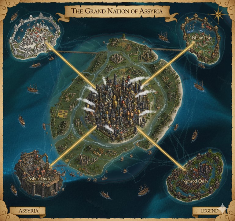
The Grand Nation of Assyria is an island nation dominated by a massive, central island with four smaller, significant islands positioned off its coasts to the northeast, northwest, southeast, and southwest. The nation is a hub of immense commerce and industry. A sprawling, golden-hued megacity sits at the heart of the main island, serving as the nation’s capital. From this central nexus, four radiant, golden roads extend outwards like the points of a compass, connecting the capital to the major coastal and island cities. These roads also serve as the demarcating boundaries for the nation’s internal states. The landscape is laced with a network of rivers, all flowing from the interior highlands outwards to the sea, facilitating trade and travel to the smaller settlements that dot the countryside between the major arteries. The surrounding ocean is teeming with vessels of all sizes, from large, multi-masted sailing ships and steam-powered merchant vessels to smaller coastal traders and barges, all indicative of a thriving and powerful maritime economy.
Major Cities
Assur, The Central Spire Located at the absolute center of the main island, Assur is the capital of Assyria and its undisputed heart of governance, industry, and culture. It is a true megacity, a dense urban landscape of towering skyscrapers that pierce the clouds, their architecture a blend of intricate masonry and metallic frameworks. Plumes of white steam constantly rise from countless stacks and vents throughout the city, a testament to the magic-driven steam technology that powers the nation’s industry and infrastructure. The city is built on a raised plateau, giving it a commanding view of the surrounding lands. It is encircled by multiple layers of thick, formidable walls, between which lie districts dedicated to manufacturing, commerce, and residences. The golden roads originate from four massive, heavily guarded gates in the city’s outer wall, channeling the lifeblood of the nation to and from its core. Within the city’s highest spires reside the ruling bodies, centers of magical research, and the headquarters of the most powerful merchant guilds.
The Twin Ports of Ishtar Positioned on two separate islands off the northeastern and northwestern coasts, the Twin Ports of Ishtar are the primary gateways for northern trade. Each port is a marvel of defensive and commercial architecture, encased in high, white-stone walls that bristle with watchtowers and defensive emplacements. Long causeways and massive bridges connect these fortress-cities to the mainland, allowing the Golden Highways to terminate directly within their gates. The harbors are vast and deep, capable of accommodating the largest sea-faring vessels. The northeastern port appears to handle the bulk of raw materials and industrial goods, with extensive warehouse districts visible, while the northwestern port seems to cater more to finished products, passenger liners, and naval fleets, featuring more ornate structures and grand plazas. Together, they form a pincer of economic and military power over the northern sea lanes.
Ashur Dock Built upon and into the rugged, rocky cliffs of the southwestern island, Ashur Dock is the most heavily fortified of Assyria’s port cities. Its construction is stern and practical, prioritizing defense and industrial might over aesthetics. The city is a fortress, with walls that appear to be an extension of the island’s natural stone. It serves as a major naval base and the primary port for the nation’s resource extraction industries, such as mining and quarrying from the mainland’s southern highlands. The harbor is protected by immense sea gates and coastal batteries. Large cranes and mechanical loading systems line the docks, constantly loading and unloading heavy cargo from specialized, steam-powered barges and freighters. The city has a gritty, industrious atmosphere, home to skilled shipwrights, armorers, and siege engineers.
Nimrod Quay Located on the southeastern island, Nimrod Quay is the commercial and leisure hub of the south. In contrast to Ashur Dock’s martial appearance, Nimrod Quay is more open and inviting, though still well-defended by elegant, bastioned walls. The architecture here is more refined, with red-tiled roofs, open-air markets, and grand estates. This city is the center for luxury goods, exotic imports, and the arts. It is the preferred port for wealthy merchants, diplomats, and travelers seeking passage on the most opulent airships and sea vessels. The surrounding waters are filled with sleek yachts and swift trading ships. Nimrod Quay also serves as the headquarters for the nation’s powerful trade consortiums and financial institutions, its quays lined with the grand facades of banks and guildhalls.
Points of Interest
The Golden Highways The four major roads that connect the capital of Assur to the coastal cities are known as the Golden Highways. They are not mere roads of packed earth or cobblestone; they are massive feats of magical engineering. They glow with a soft, golden light, providing safe passage day and night. Raised above the surrounding land and perfectly straight, they allow for the rapid transit of goods, troops, and information across the nation. These highways are the primary arteries of Assyrian commerce, constantly traversed by steam-powered wagons, merchant caravans, and patrols of the state guard.
The Riverlands The main island is divided into three distinct states or provinces by the Golden Highways. The lands between the highways are fertile plains and rolling hills, crisscrossed by an extensive network of rivers. These rivers, such as the northern Dianu, the southeastern Urartu, and the southwestern Zab, are vital for internal commerce and agriculture. They are navigated by shallow-draft barges and riverboats, transporting agricultural products from the numerous farming villages and towns to the major cities. The riverbanks are lined with lush fields, orchards, and pastures, forming the breadbasket of the nation. Smaller bridges and ferries provide passage where the rivers intersect with local roads. The confluence of the rivers near the central plateau creates a marshy, yet rich, landscape that provides resources for alchemical and magical components.
The Grand Nation of Assyria is a realm of stark contrasts and bustling life, where the gleaming superstructure of the central megacity of Assur presides over a landscape rich with resources and dotted with vibrant secondary communities. The terrain of the main island is dominated by a large, central plateau upon which Assur is built. This plateau gradually slopes downwards in all directions, giving way to rolling hills and fertile plains that are crisscrossed by a network of rivers. The land is most fertile in the river valleys, which are densely populated with farming hamlets and agricultural towns. As one moves further from the central plateau and towards the coasts, the terrain flattens into wide coastal plains, which are home to larger fishing villages and market towns that feed into the major port cities. The four smaller islands each have their own unique topography: the northern islands of the Twin Ports of Ishtar are relatively flat, allowing for the sprawling urban development of the ports; the southwestern island of Ashur Dock is mountainous and rugged, with sheer cliffs that drop into the sea; and the southeastern island of Nimrod Quay is characterized by gentle slopes and sandy beaches, making it an ideal location for leisure and commerce.
Secondary Communities and Terrain
- The Northern Plains (State of Ninua): The region defined by the land north of the southeastern and southwestern Golden Highways is known as the State of Ninua. This expansive, fertile plain is the breadbasket of Assyria. The land here is a patchwork of vast, golden wheat fields, sprawling vineyards, and lush orchards. The Dianu River and its many tributaries meander through this landscape, their banks lined with small farming villages and hampty-towns. A significant secondary community in this region is the town of Khorsabad, located at a major confluence of the Dianu River. Khorsabad is a bustling agricultural hub, with a large, open-air market where farmers from the surrounding plains sell their produce. The town is also known for its skilled artisans who craft fine ceramics and textiles. Further north, nestled in the foothills that rise before the coastal plains, are numerous mining settlements that extract iron and copper from the earth, supplying the forges of Assur and the shipyards of Ishtar Port.
- The Southern Highlands (State of Kalhu): South of the northeastern and northwestern Golden Highways lies the State of Kalhu, a region of rugged hills and dense forests that gradually rise into a small mountain range at the island’s southern tip. This area is rich in timber, stone, and precious metals. The Zab River cuts through this territory, its fast-flowing waters powering numerous sawmills and stone quarries. The largest secondary community here is the town of Balawat, a fortified settlement built into the mountainside. Balawat is a mining town through and through, its population consisting mainly of miners, stonemasons, and engineers. The town is a vital source of granite and marble for the grand construction projects in Assur and Ashur Dock. The deep forests of Kalhu are also home to reclusive communities of hunters and trappers who supply rare woods, medicinal herbs, and exotic beast hides to the markets of Nimrod Quay.
- The Eastern Wetlands (State of Arbela): The land to the east of the central capital, between the northeastern and southeastern Golden Highways, forms the State of Arbela. This low-lying region is characterized by extensive marshes and wetlands, fed by the slow-moving Urartu River. The area is a mosaic of rice paddies, aquaculture farms, and peat bogs. The largest settlement in this state is the stilt-city of Til Barsip, built directly over the marshes. The inhabitants of Til Barsip are master fishermen and alchemists, renowned for their ability to harvest rare alchemical reagents from the unique flora and fauna of the wetlands. The city is a labyrinth of wooden walkways and platforms, connected by a network of canals plied by flat-bottomed boats. The peat harvested from the bogs is a primary fuel source for many of the smaller communities and is also used in the alchemical processes that are central to the region’s economy.
Trade Routes and Natural Resource Zones
- The Golden Highways: These magically-infused superhighways remain the primary arteries of land-based trade, facilitating the rapid movement of goods between the capital and the major ports. Heavily armored steam-wagons transport high-value cargo such as processed metals, advanced magical components, and luxury goods, while larger, slower-moving caravans handle bulk shipments of grain, timber, and stone. The highways are patrolled by the elite Assyrian Guard, ensuring their safety from bandits and monstrous creatures.
- The Riverine Trade Network: The rivers of Assyria form a secondary, yet vital, trade network. Barges and riverboats, powered by a combination of steam and elemental magic, ply these waterways, transporting agricultural goods from the rural heartlands to the urban centers. The Dianu River is the primary route for grain and produce from the Northern Plains to the Ishtar Ports. The Zab River is used to float massive rafts of timber from the Southern Highlands to Ashur Dock. The Urartu River, with its network of canals, facilitates the trade of fish, rice, and alchemical supplies from the Eastern Wetlands to Nimrod Quay and Assur.
- Maritime Trade Routes: The sea lanes connecting the major ports are the lifelines of Assyria’s international trade. The Twin Ports of Ishtar are the hub for trade with the northern continents, importing raw materials like exotic woods and rare minerals, and exporting finished goods such as steam-powered machinery and magical artifacts. Ashur Dock handles the bulk of the nation’s resource exports, primarily timber and quarried stone, to the southern lands. Nimrod Quay is the center for luxury trade with the eastern nations, importing silks, spices, and exotic creatures, while exporting fine wines, intricate jewelry, and potent magical potions.
Natural Resource Zones
- The Iron Hills: Located in the northern foothills of the main island, between the two Ishtar Ports, lies a region rich in iron and copper ore. This area is dotted with numerous open-pit mines and smelters, the smoke from their chimneys a constant fixture on the horizon. The proximity of these resources to the industrial forges of the Ishtar Ports is a major contributor to Assyria’s naval and military might.
- The Sunstone Quarries: In the rugged mountains of the southwestern island, near Ashur Dock, are the famed Sunstone Quarries. This unique, golden-hued crystalline stone is not only a beautiful building material but also possesses inherent magical properties, making it a key component in the construction of the Golden Highways and other major magical infrastructure projects. The quarrying of Sunstone is a difficult and dangerous process, overseen by the most skilled engineers and earth-mages in the nation.
- The Whispering Woods: A vast, ancient forest in the heart of the Southern Highlands, the Whispering Woods is a source of both valuable timber and mystical resources. The towering, dark-barked trees of this forest are prized for their strength and resilience, making them ideal for shipbuilding. The forest is also home to a variety of magical flora and fauna, including the elusive Glimmerwood trees, whose sap is a powerful ingredient in potions of illusion and invisibility. The woods are rumored to be inhabited by ancient spirits and fey creatures, making them a place of both great opportunity and great peril.