
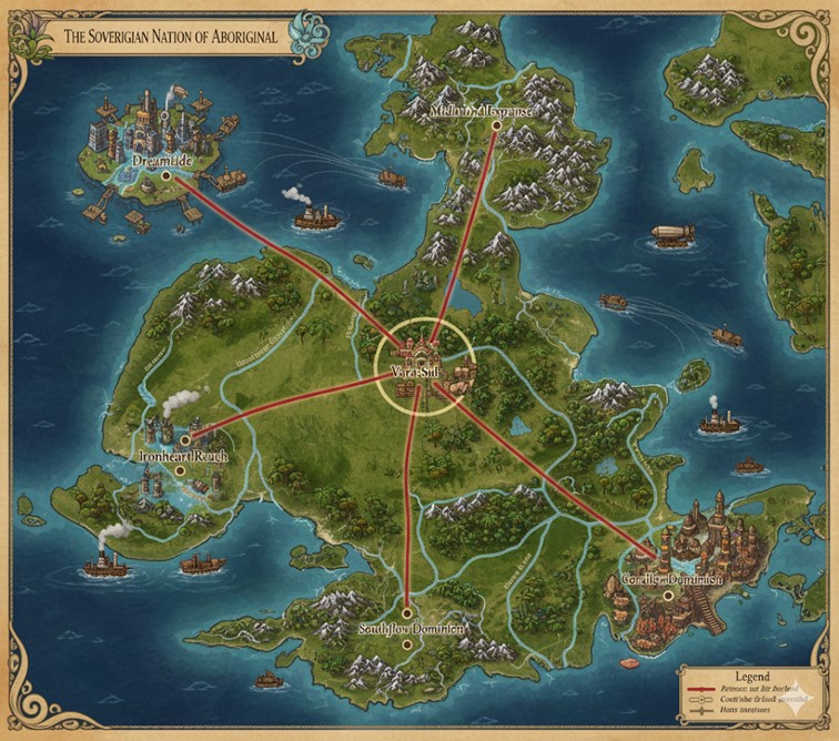
This map depicts The Sovereign Nation of Aboriginal, rendered in a classic, antique style with an ornate, flowing border. The geography is dominated by a large central landmass surrounded by a smaller archipelago, showcasing a diverse landscape of lush green jungles, plains, formidable mountain ranges, and an intricate network of rivers.
A key feature is the nation’s infrastructure, which is organized in a clear hub-and-spoke model. Major arterial roads, known as Petrasectus roads, radiate from the centrally located capital, connecting it to prominent coastal cities. A secondary network of Coastal and Intercostal roads links these major hubs and smaller settlements. The map is alive with activity, illustrating a thriving economy with steamships navigating the rivers and coastal waters, and airships traversing the skies, all indicative of the nation’s blend of magic and steam-powered industry.
Major Cities
Vara-Sul (The Capital)
Located at the geographic and political heart of the nation, Vara-Sul is the nexus from which all major roads originate. As the seat of the matriarchal monarchy, it is the undisputed administrative, cultural, and economic center of Aboriginal. The city is strategically positioned inland but maintains control over the nation’s commerce through its command of the transportation network. Its architecture is likely a grand fusion of magically-treated stone skyscrapers and industrial steamworks, housing the majority of the nation’s leadership and a dense, bustling population.
Dreamtide
Situated in the northwest, Dreamtide is depicted as a massive industrial port city, built upon or alongside the water on a series of interconnected platforms and docks. As a major hub for both naval and aerial trade, its skyline is marked by the smokestacks of steam-powered factories and the docking towers for airships. Given its name and connection to the faith of Aboriginalism, it is likely the home of the Grand Dreampool, making it not only an industrial powerhouse but also a major spiritual center for the followers of Yirra.
Ironheart Reach
To the west, nestled at the mouth of the Ironflow River, lies Ironheart Reach. Its proximity to the mountains and its functional, fortified appearance suggest it is the industrial heartland for mining and metallurgy. This city likely processes raw materials extracted from the nearby peaks, using the river to ship refined metals and heavy machinery to the rest of the nation. It is a city built on strength, industry, and the practical application of steam power.
Southflow Dominion
Located on the southern coast at the end of the Shimmering River, Southflow Dominion appears to be the agricultural center of Aboriginal. Surrounded by vast plains and fertile riverlands, this city serves as the nation’s breadbasket, managing the cultivation and distribution of food and other natural resources. Its economy is likely focused on agriculture, textiles, and trade in raw organic goods, making it a prosperous but more serene hub compared to the industrial cities.
Coralis Dominion
In the southeast, Coralis Dominion is a unique coastal city whose architecture appears to be organically integrated with the surrounding marine environment, possibly built from magically shaped coral. This city is a center for aquatic trade, fishing, and diplomacy with the sentient marine life mentioned in Aboriginal’s lore. Its culture is deeply connected to the ocean, and it serves as a vital link to the resources and mysteries of the sea.
Melodious Expanse
In the mountainous north, Melodious Expanse is a more isolated city. Its name and location suggest it is a center for the arts, culture, and scholarship. Tucked away among the high peaks, it may be a place of retreat for artisans and thinkers, known for unique crafts, music, and knowledge that are inspired by its majestic and secluded surroundings.
Points of Interest
States and Boundaries
The five major Petrasectus roads radiating from Vara-Sul serve a dual purpose. In addition to being primary transportation arteries, they also function as the official boundaries for the nation’s major states or provinces. Each of these five regions is anchored by one of the major coastal cities, which acts as its regional capital and economic hub. This division creates a clear and organized administrative structure for the entire nation.
Rivers and Commerce
The map details several major rivers that are the lifelines of the nation’s internal commerce.
- The Ironflow River in the west is a key route for transporting ore and metal goods from Ironheart Reach.
- The Shimmering River in the south irrigates the fertile plains and carries agricultural goods from the Southflow Dominion.
- Other named rivers like the Whisperwind River, Glimmerstream, and Sunstone River connect the interior to the coast, allowing steamships to move resources and people throughout the nation efficiently.
Transportation Network
The infrastructure of Aboriginal is robust and multifaceted.
- Petrasectus Roads: These are the primary, heavily trafficked highways connecting the capital directly to the main coastal hubs, ensuring the swift movement of armies, official decrees, and high-priority trade.
- Coastal/Intercostal Roads: This secondary network connects the major cities to each other along the coast and links smaller towns and villages, facilitating regional trade and travel.
- Air Travel: Numerous airships and zeppelins are shown traversing the skies. This signifies that air travel is a common and vital mode of transport for passengers and high-value cargo, bypassing difficult terrain like mountains and dense jungles.
The national map of Aboriginal reveals a thriving island nation deeply integrated with its diverse, high-magic environment. The intricate detail showcases not only the primary settlements and infrastructure but also the underlying economic and ecological tapestry that sustains this steampunk-magic society.
Terrain and Environments
Aboriginal’s landmass is a mosaic of varied biomes, each influencing the local economy and settlement patterns:
- Lush Jungles: Dominating the central and western interior, these dense green areas are characterized by towering, ancient trees and are likely home to the bioluminescent flora and unique monsters previously mentioned. These jungles are interspersed with smaller rivers and hidden ruins of older civilizations, offering rich, untamed wilderness. Travel through these areas off the main roads is challenging, often relying on griffon couriers or specialized jungle-adapted steam vehicles.
- Mountain Ranges: Formidable peaks, notably in the north (near Melodious Expanse) and west (flanking Ironheart Reach), define significant portions of the landscape. These mountains are not just geographical barriers but also critical resource zones. Their rugged terrain also influences the path of rivers, creating cascading waterfalls which are often harnessed for magic and steam power.
- Fertile Plains: South of Vara-Sul, extending towards Southflow Dominion, are expansive green plains. These flatlands are ideal for agriculture, making them the breadbasket of the nation. They are well-watered by the Shimmering River and its tributaries.
- Coastal Cliffs and Beaches: The coastline is highly varied, from the coral-encrusted cliffs near Coralis Dominion to sandy stretches and natural harbors. These coastal areas are vital for maritime trade and host numerous fishing villages and smaller port towns.
- Inland Lakes: Several large, clear lakes are visible in the northern interior, particularly southwest of Melodious Expanse. These likely serve as freshwater sources, fishing grounds, and potential sites for smaller, more secluded communities or ritualistic Dreampools.
- Archipelago and Smaller Islands: Beyond the main landmass, numerous smaller islands are scattered in the surrounding seas. Some are sizable enough to host secondary cities or outposts, while many others are uncharted, potentially appearing and disappearing, adding an element of mystery and adventure to the maritime routes. These often serve as secluded havens, minor trade stops, or monster lairs.
Secondary Cities and Settlements
Beyond the six major hubs, several secondary cities and smaller settlements dot the landscape, each playing a role in Aboriginal’s economy and defense:
- Coastal Towns/Ports: Numerous small towns are visible along the coastline, particularly near natural harbors or river mouths. These settlements act as fishing villages, minor trade posts, and waystations for steamships and smaller vessels. They are critical for local resource extraction (e.g., seafood, coastal flora) and for connecting rural areas to the larger economic network.
- Jungle Outposts/Villages: Deep within the jungles, smaller clearings and villages suggest hidden communities. These might be subsistence-focused, relying on jungle resources, or specialized in unique magical flora/fauna. They would primarily connect to the main network via rough tracks, riverboats, or air travel.
- Mining Camps/Hamlets (near Ironheart Reach and Melodious Expanse): While not explicitly named, the mountainous regions undoubtedly contain smaller settlements dedicated to resource extraction. These would be rugged, functional communities focused on mining precious metals, rare minerals, or magical crystals, transporting their finds to Ironheart Reach or Melodious Expanse for processing.
- Riverine Communities: Along the banks of the major rivers, particularly the Ironflow, Shimmering, and Whisperwind, small towns would naturally form. These settlements would focus on river-based trade, fishing, and possibly the operation of steam-powered mills or water purification plants that supply larger cities.
Trade Routes
Aboriginal’s economy thrives on an extensive, multi-modal trade network:
- Major Road Network (Petrasectus & Coastal/Intercostal):
- From Vara-Sul: High-value manufactured goods, enchanted items, and administrative mandates flow outward.
- To Vara-Sul: Raw resources, agricultural products, and processed goods from the major coastal cities converge.
- Coastal Loops: Facilitate regional exchange, allowing cities like Dreamtide, Ironheart Reach, Southflow Dominion, and Coralis Dominion to trade with each other directly without always routing through the capital. This allows for the movement of specialized goods—e.g., textiles from Southflow to Coralis for aquatic-resistant clothing, or refined metals from Ironheart to Dreamtide for airship construction.
- River Trade (Steamships and Barges):
- Ironflow River: Carries mined resources (ores, metals, gems) from the western mountains down to Ironheart Reach and then further along the coast or inland.
- Shimmering River: Transports agricultural produce (grains, fruits, livestock) from the plains around Southflow Dominion to other regions, including the capital.
- Whisperwind River & Glimmerstream: These rivers would be crucial for transporting timber from the jungles, unique magical ingredients, and perhaps rare animal hides to urban markets.
- Inter-island Ferries: While not explicitly marked, numerous steamship routes would connect the smaller outlying islands to the main landmass, bringing unique local resources, fresh catches, and linking their communities to the national economy.
- Air Trade (Airships and Zeppelins):
- High-Value Goods: Airships depicted crisscrossing the map indicate rapid transport of valuable cargo, specialized magical components, urgent communications, and passengers between all major cities.
- Overcoming Terrain: Air routes bypass the slow and often dangerous terrestrial paths through jungles and mountains, providing efficient links between even the most isolated population centers like Melodious Expanse. These routes would also connect the floating cities to the rest of the nation.
- Luxury Travel: Zeppelins likely offer comfortable, long-distance journeys for the affluent, with their distinctive silhouettes a common sight in Aboriginal’s skies.
Natural Resource Zones
The map implies several key resource zones that fuel Aboriginal’s economy and magic:
- Mountainous Regions (near Ironheart Reach and Melodious Expanse): These areas are prime sources of precious metals (gold, silver, platinum), various ores (iron, copper), and potentially magical crystals or rare earth minerals essential for high-tier magical gear and steam engine components.
- Jungles (central and western interior): These dense forests provide timber for construction and fuel (though steam is derived magically, wood might still be used for certain processes), exotic flora and fauna for alchemical ingredients, and rare magical herbs. The “forgotten areas with ruins” within the jungles also hint at archaeological resources and ancient magical artifacts.
- Rivers and Lakes: Critical for water-based magic (hydromancy), steam generation, freshwater, and fishing. The magical currents within them are also sources of ley line energy for Dreampools and industrial power.
- Coastal and Marine Areas (near Coralis Dominion and Dreamtide): Abundant seafood, unique marine flora, coral (used as a building material or magical component), and sea salt. Underwater population centers would likely harvest deep-sea resources.
- Fertile Plains (near Southflow Dominion): Rich agricultural land for crops (grains, fruits, vegetables) and livestock. These areas are vital for feeding Aboriginal’s large population.
Additional Information
- Megacities and Floating Cities: The depiction of Dreamtide clearly shows a sprawling floating city, reinforcing the lore of advanced architectural and magical engineering. Vara-Sul and Coralis Dominion also hint at dense urban development.
- Uncharted Islands: The presence of numerous smaller, often uncharted islands emphasizes the element of exploration and the potential for discovering new resources, forgotten ruins, or encountering unique monsters. The magical appearance and disappearance of some smaller islands add to the world’s mystique.
- Defense and Security: The clear road network and the presence of major cities imply the need for coordinated defense against the myriad monsters inhabiting Aboriginal. Military outposts (not explicitly marked but implied by strategic locations) would safeguard key routes and resource zones. The cities themselves, particularly coastal ones like Dreamtide, would have robust defenses against both land and sea threats, utilizing water walls, steam blast waves, and airship patrols.